

Major Abraham Kirkpatrick was not one to mince words. “There is a few of them Damned Cherokees,” he reported in July 1784, “near 40 men, settled on Siota about the old Chillicoffee Towns . . . These is the Villains that killed the family at the blue licks,” he continued, “as is still doing mischeif on some parts of the settlements.”
Kirkpatrick was one of Lt. Col. Richard Clough Anderson’s deputy surveyors and had just returned home to Pittsburgh after more than three months in the wilderness. While surveys for Virginia veterans continued in Kentucky’s Green River District, Kirkpatrick had been tasked with assessing things in the still off-limits Ohio Military District on his way home. “Tis absolutely necessary that they should quit that country before we attempt to Survey,” the one-eyed soldier insisted. “Them and us can’t both reside there at the same time. We came near them (perhaps within 10 miles) but avoided going to the old Towns for fear of them and was verry carefull that they would not even hear of us.”[1]
Near Philadelphia, Gen. Peter Muhlenberg, also just back from Kentucky, worried about bigger threats than the forty Cherokee camped near old Chillicothe (Westfall, Ohio). He advised Congress: “This is the critical time . . . to establish peace or to prevent them from forming a combination against us.”
The Six Nations Confederacy had shown a century before what Native unity could achieve, and Ottawa war chief Pontiac helped form a powerful multi-tribe offensive in the 1760s. But in 1784, Muhlenberg feared war might simply be a consequence of Congressional inaction. An Indian confederacy was on hold, he said, only because the Shawnee refused to join “until they should be fully apprised of our intentions” and due to “a quarrel which arose between the Kickapoos and Chickasaws.” The lack of diplomacy made the Shawnee suspicious. Those he met with at Fort Nelson “gave us repeated hints, that if we meant to take any of their lands on the West side of the Ohio, it would not be given up without a contest.” The Shawnee were key. “If a general Treaty cannot be held at this time,” Muhlenberg advised, “a partial treaty with them would keep the other Nations quiet and give us so much time at least as will be necessary to provide against the worst. If this is not done before the Fall,” he warned, “I am convinced from the present situation of affairs that a War is unavoidable.”[2]

Thomas Jefferson’s Vision
Crafting a policy for the Northwest Territory’s administration was the most consequential matter considered by the post-war Congress of the Confederation.[3] Many Americans believed they had a natural right to take unsettled land. Defending poor North Carolinians before the war, Herman Husband argued, “it has been the Opinion of all the Several Legislative Bodies, both of Great Britain and her Colonies, that peaceable Possession, especially of the back waste vacant Lands, is a Kind of Right, always looked upon quite sufficient to entitle them to the Preference of Refusal of a farther Title.”[4] Thomas Jefferson wrote in 1774 that where no civil institution was established to assign rights to vacant land, “each individual of the society may appropriate to himself such lands as he finds vacant, and occupancy will give him title.”[5] Virginia’s preemption law upheld these views, though the size and availability of preemption claims was limited. It was not hard for Virginians to think of Kentucky as “vacant” even of Native settlement. Seasonal hunting camps had been the extent of Native residence in the region for decades. The same could not be said for Ohio or Tennessee, where several tribes had permanent communities large enough to be called “towns.”
Though his own colony held most of the territory in question, Jefferson proposed in 1776 that the west be divided into new states that would be “free and independent of this colony and all the world.”[6] Jefferson’s ideas were represented in Virginia’s October 20, 1783, statute ceding the Northwest Territory. The land was to be “formed into . . . distinct republican states” that would be “admitted members of the federal union; having the same rights of sovereignty, freedom, and independence, as the other states.”[7]
Jefferson returned to Congress for the first time since 1776 and joined Samuel Hardy, Arthur Lee, and James Monroe in signing the Deed of Cession.[8] He also took over an existing project to “prepare a plan for the temporary government of the Western territory.” The Sage of Monticello was a proponent of agrarian democracy and sought to ensure the land was distributed in modest quantities to actual settlers, rather than in large amounts to wealthy speculators.[9] He drafted plans for new states, giving them names like “Saratoga” and “Metropotamia.”[10] He believed the Old Dominion was too large to sustain Republican governance, and that the new states should be small for the same reason. Limited size, a historian has explained, would “preserve the homogeneity of the interests, opinions, and habits of the citizens.” The diversity that came with larger states would require a dangerously strong central government to maintain order.[11]
“The Western world opens an amazing prospect as a national fund,” wrote Rhode Island delegate and Jefferson ally David Howell, believing the territory sufficient to pay off the nation’s debts. “As a source of future population and strength,” he added, “it is a guaranty to our independence. As its inhabitants will be mostly cultivators of the soil, republicanism looks to them as its guardians.” With a nod to Sallust and the Old Testament, he predicted, “When the states on the eastern shores, or Atlantic, shall have become populous, rich and luxurious, and ready to yield their liberties into the hands of a tyrant, the gods of the mountains will save us, for they will be stronger than the gods of the valleys.”[12]

Jefferson’s report was submitted on the same day the deed of cession was signed. Congress approved it with some revisions on April 23, 1784, the day the Virginia State Line conducted its bounty land lottery at Fort Nelson. Though it has long been called “the Ordinance of 1784,” it seems to have been viewed only as a plan. The Land Ordinances of 1785 and 1787 were the ones that carried the force of law. Still, Jefferson established the principle that western lands would be governed first as “territories” and permitted, when sufficiently populated, to form themselves into states.
George Washington’s Advice
George Washington had spent many years scheming to acquire western land, but told Congress in September 1783 that it was imperative the Northwest Territory not be “over run with Land Jobbers, Speculators, and Monopolisers or even with scatter’d settlers.”[13] As early as 1775, John Floyd had complained about “land jobbers” who would “go about in companies and build 40 or 50 cabins” on vacant tracts.[14] “This business has been attended with much villainy in other parts,” wrote a Kentucky friend of James Madison’s, “Here it is reduced to a system, and to take advantage of the Ignorance or the Poverty of a neighbor is almost grown into reputation.”[15]
Orderly settlement was essential, and some system of government was crucial to achieving it. “It may seem a little extraneous, when I am called upon to give an opinion upon the terms of a Peace proper to be made with the Indians, that I should go into the formation of New States,” Washington admitted, “but the Settlemt. of the Western Country and making a Peace with the Indians are so analogous that there can be no definition of the one without involving considerations of the other.”[16]
A British officer reported from Detroit at this time that the Indians “begin to fear they are to be the dupes of war.”[17] Washington explained that “maugre all the advice and admonition which could be given them at the commencement; and during the prosecution of the War,” most of the tribes “could not be restrained from acts of Hostility, but were determined to join their Arms to those of G Britain and to share their fortune.” The future president asserted in the language of Indian diplomacy that “with a less generous People than Americans they would be made to share the same fate; and be compelld to retire along with [the British] beyond the Lakes.”[18] The precedents were unarguable. The British had expelled the Acadians from Canada’s maritime provinces during the French and Indian War, and the Six Nations, Creeks, and other tribes had similarly expelled weaker peoples from their homes after victories in war.[19]

Yet Washington strongly advised that Congress not take full advantage. Prioritizing peace, he believed the tribes were now convinced “of their error in taking up the Hatchet” against the United States. “As the Country, is large enough to contain us all,” he reasoned, “and as we are disposed to be kind to them and to partake of their Trade, we will from these considerations and from motives of Comp[assio]n, draw a veil over what is past and establish a boundary line between them and us beyond which we will endeavor to restrain our People.”
“In establishing this line,” Washington advised, “care should be taken neither to yield nor to grasp at too much.” He believed it was important for Congress’s treaty negotiators “to impress the Indians with an idea of the generosity of our disposition to accommodate them, and with the necessity we are under, of providing for our Warriors, our Young People who are growing up, and strangers who are coming from other Countries to live among us.” Should the Indians be dissatisfied with the line, “compensation should be made them for their claims within it.”
The general was adamant that Americans not overreach. If, for example, “the Legislature of the State of New York should insist upon expelling the Six Nations from all the Country they Inhabited previous to the War . . . it will end in another Indian War.” Moreover, he asserted, “a Proclamation in my opinion, should issue, making it Felony . . . for any person to Survey or Settle beyond the Line; and the Officers Commanding the Frontier Garrison should have pointed and peremptory orders to see that the Proclamation is carried into effect.”[20]
The First American Regiment
The Treaty of Paris was ratified by Congress in Annapolis, Maryland, on January 14, 1784. British troops had left New York and Charleston, and it was taken for granted that they would soon vacate the six forts they occupied on the Great Lakes, the St. Lawrence River, and Lake Champlain.[21] Congress was told it was “indispensibly necessary” to send troops to occupy the forts “to give success to the negotiations with the Indians.”[22] They had to show there was a new sheriff in town.
There were still a few hundred Continental troops at West Point and Fort Pitt. The fastest way to take possession of the forts was to send the soldiers who had the most time left in their enlistments while raising a new regiment to relieve them. But the notion of raising regular troops in peacetime raised immediate objections. Elbridge Gerry of Massachusetts argued that any interpretation of the Articles of Confederation that enabled Congress to make “requisitions for a small number of land forces for a short period” must also allow for large armies with long enlistments and put America on a path to despotism. After significant debate, all but eighty of the remaining veterans were discharged, and Congress “recommended” that Connecticut, New York, New Jersey, and Pennsylvania raise enough men out of their militias to form a 700-man regiment to take control of the forts.[23]
The lieutenant colonel commandant of this regiment was Philadelphian Josiah Harmar, a veteran of the Pennsylvania Continental Line.[24] He commanded with a Pennsylvania commission until 1786, and his men served as State troops “in Continental service” with one-year enlistments.[25] Harmar and his soldiers were completely unfamiliar with the frontier.[26]
Though Harmar’s regiment came nowhere close to full recruitment, protecting the treaty commissioners and expelling illegal settlers were quickly added to its mission.[27] Trespassing notices were posted at Wheeling and other places, and Harmar sent out a detachment “to dispossess sundry persons who had presumed to settle on . . . the western side of the Ohio river.”[28] Ensign John Armstrong returned to report that, despite his efforts, people were “moving to the unsettled countries by forties and fifties,” and many of them were people “flying from justice.” He estimated that there were more than 300 families at the falls of the Hockhocking and an equal number on the Muskingum. There were still more at the “old Moravian Town” (Gnadenhutten) and more than fifteen hundred on the rivers Miami and Scioto. There was at least one family settled on every bit of bottomland “from Wheeling to the Sciota.” Harmar ordered Captains John Doughty and Jonathan Heart to “take post at or near the mouth of Muskingum” with the job of “removing the intruders from the public lands should any hereafter presume to encroach on them.” Deciding that “lenity” was “out of the question,” he “directed Captain Doughty, on his way down” the river, “to burn and destroy any remaining cabins between [Fort] McIntosh and Muskingum.”[29]
Some settlers voiced legal objections. John Emerson argued that “all mankind, agreeable to every constitution formed in America, have an undoubted right to pass into every vacant country, and there to form their constitution.” Congress, under the Articles of Confederation, was “not empowered to forbid them, neither is Congress empowered from that confederation to make any sale of the uninhabited lands to pay the public debts, which is to be by tax levied and lifted by authority of the legislature of each state.”[30]
Indian Treaties
America’s Indian treaties are held up for scorn today, but it is clear that thought and effort went into the earliest of them. They channeled Washington’s desire to be firm, fair, and measured. The first was signed on October 22, 1784, at Fort Stanwix (Rome), New York, with the six nations of the Haudenosaunee. Representing Congress were Connecticut’s Oliver Wolcott, a veteran of the Revolution and two earlier Indian Wars; Pennsylvania’s Richard Butler, a veteran with substantial experience in Indian diplomacy; and Virginia’s Arthur Lee, a senior diplomat who had spent a decade representing America in London and Paris. Land was taken from the Seneca, Mohawk, Onondaga, and Cayuga. The Oneida and Tuscarora, both wartime American allies, were “secured in the possession of the lands on which they are settled.”[31]
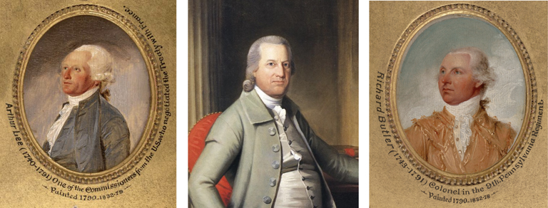
George Rogers Clark took Wolcott’s place when the treaty commissioners traveled west to meet with the Wyandots and Delaware at Fort McIntosh (Beaver, Pennsylvania). Lee reported that these tribes “held out an idea to the Continental Commissioners that they still looked upon the lands which the United States held by the treaty with Great Britain as their own.” The commissioners answered “in a high tone,” explaining that as the tribes “had adhered during the war to the king of Great Britain, they were considered by us as a conquered people and had therefore nothing to expect from the United States, but must depend altogether upon their lenity and generosity.”[32] A significant portion of trans-Ohio land was taken for settlement. Still, the treaty declared that anyone attempting “to settle on any of the lands allotted to the Wyandot and Delaware nations . . . shall forfeit the protection of the United States, and the Indians may punish him as they please.”[33]
The militant Shawnee refused to join the proceedings at Fort McIntosh. It was not until the Treaty of Fort Finney, in January 1786, that Shawnee names were put to parchment. One of the signing witnesses was a Wyandot Indian named Isaac Zane, who had been abducted in 1754 from his white family on the South Branch of the Potomac River. Fort Finney stood at the mouth of the Great Miami River (west of North Bend, Ohio), and the treaty permitted the Indians to live and hunt to the west of that waterway in modern Indiana.[34]
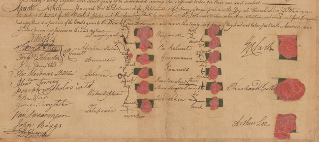
The Treaty of Fort Finney was agreed to shortly after the Treaties of Hopewell were signed with the Cherokee, Choctaw, and Chickasaw. Hopewell was the South Carolina home of militia general Andrew Pickens, who was joined in the negotiations by Benjamin Hawkins, Joseph Martin, and, for a time, Gen. Lachlan McIntosh, who built the Ohio River fort that carried his name in 1778. Like the others, these treaties provided that any white encroacher would “forfeit the protection of the United States, and the Indians may punish him or not as they please.” The Chickasaw treaty, signed on January 10, 1786, reserved land west of the Tennessee River for that tribe.[35] The treaty was signed one year and four days after Gov. Patrick Henry suspended Virginia State Line surveys there, and made the suspension permanent.[36]
As the new proprietor of the Northwest Territory, Congress used its authority to bolster the treaties. On September 22, 1785, it became official policy that it was “essential to the welfare and interest of the United States” and “necessary for the maintenance of harmony and friendship with the Indians” that “all cause of quarrel and complaint between them and the United States . . . should be removed and prevented.” Congress acted to “prohibit and forbid all persons from making settlements on lands inhabited or claimed by Indians without the limits or jurisdiction of any particular state, and from purchasing or receiving any gift or cession of such lands or claims, without the express authority and directions of the United States.” Going forward, any such purchase would be “null and void.”[37]
The Wyandots and the Delaware initially complied with the terms of the Treaty of Fort McIntosh, returning their prisoners by June 1785. However, it was evident as early as December 1784 that the British garrisons would not evacuate the northern forts. The small army Congress had sent provided little incentive for them to leave. Harmar clearly stated what was becoming obvious: the Indian treaties were meaningless without control of Detroit. He reported that British emissaries were working to make the Indians “entertain a bad opinion of the Americans.” One such emissary was the notorious turncoat Simon Girty, a former lieutenant in the Virginia Line. A few weeks later, Harmar reported that the “Indians down the River,” including the Shawnee, Miami, Cherokee, and Kickapoo, had “killed and scalped several adventurers—settlers on their lands.” In October, Captain Doughty observed, “If a confederacy of the Indian tribes to the westward should take place, of which there is a prospect, they will become very formidable from their numbers.”[38]
The Northwest Territory
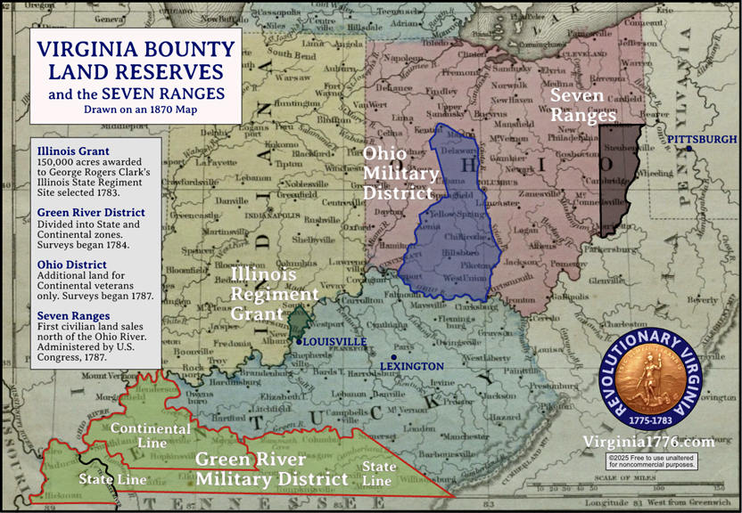
The Indian treaties were completed nonetheless, and Gov. Edmund Randolph opened the Illinois Grant and the Ohio Military District on January 25, 1787.[39] Clark’s soldiers took possession of their land, and surveyors got to work between the Scioto and Little Miami. Croghan reported that by September 1788, 724,045¾ acres had been surveyed there for the Continentals and 867,672¾ acres had been surveyed for the State Line. He estimated there were no more than two million good acres in the Ohio Military District and was aware of 3,675,355⅔ acres in issued warrants between the State and Continental lines. He anticipated a deficiency of 1,675,355⅔ acres.[40]
Croghan’s State Line number seems to include the land west of the Tennessee, which remained off limits to any white settlement until Andrew Jackson pressured the Chickasaw to sell it in 1818. Even then, more than three decades and another war distant from the Revolution, the Commonwealth of Kentucky threw up hurdles that blocked veterans from executing their warrants there.[41]
The Northwest Ordinance of 1787 organized the first incorporated territory of the United States and set the foundation for westward expansion. It provided a framework for territorial governance, the creation of new states, and guaranteed fundamental rights such as religious freedom and trial by jury. It prohibited slavery above the Ohio River, making the waterway a dividing line between free and slave regions years before the Mason-Dixon Line acquired that status (slavery was then still legal in New York and New Jersey, and in the earliest stages of being phased out in Pennsylvania, Connecticut, and Rhode Island).

The ordinance still further affirmed Native American rights in strong terms:
The utmost good faith shall always be observed towards the Indians; their lands and property shall never be taken from them without their consent; and, in their property, rights, and liberty, they shall never be invaded or disturbed, unless in just and lawful wars authorized by Congress; but laws founded in justice and humanity, shall from time to time be made for preventing wrongs being done to them, and for preserving peace and friendship with them.[42]
The decentralized nature of Indian politics, the refusal of many settlers to comply with the law, and continued British occupation of the northern forts made war inevitable. Josiah Harmer was defeated by an Indian army in 1790, and a larger army sent under Arthur St. Clair was hacked to pieces in 1791. Anthony Wayne prevailed in a third campaign in 1794, but it was not until the War of 1812 and the Battle of the Thames that American control was firmly established. Today, the territory is organized as the states of Ohio, Indiana, Illinois, Michigan, Wisconsin, and the eastern third of Minnesota. All those states were once part of Virginia.
Congress’s Debts
The work of distributing land to Virginia’s veterans, their assignees, and descendants continued for decades. As memories faded, confusion about who was entitled to what crept into the process. In 1833, Gov. John Floyd, son of the since-murdered Fincastle surveyor, appointed John H. Smith to conduct a thorough review of all relevant laws by digging through a trove of documents found stored in the Richmond capitol attic. Of particular concern was the Revolutionary legislature’s intentions for the Illinois Regiment.[43] The limited range of the Illinois Grant had apparently robbed those men of their due.
Smith found that the Illinois Regiment’s 150,000-acre grant “is nowhere said to be, and therefore it may be presumed was not intended to be, in lieu of all former provisions, made by law in their favour.” The old legislature understood, he determined, that “service in the Illinois country was one of privation, hardship, toil and danger; and therefore deserved extraordinary compensation.” Illinois regiment veterans were, therefore, entitled to their portion of that land and the usual share given to State Line veterans.[44] Of all Virginia’s veterans, an initial review identified 50 officers still entitled to land, mainly from the State Line.[45] An 1834 audit found that of an estimated 11,000 total potential claims from State and Continental service, only 6,136 veterans (or their heirs or assignees) had claimed their land. The primary reason, Smith assessed, was that “it appears that the officers, &c. of the state line, who had not surrendered their warrants prior to the 6th of January, 1785, (and they are many,) have been utterly precluded from the satisfaction of their claims.”[46] Chickasaw occupation of the land beyond the Tennessee River, the Treaty of Hopewell, and Kentucky law had prevented them from getting what had been promised to them four decades prior.[47]
There was no way of fixing that now, but Smith discovered another unpaid debt. “After having acquired and held this [Northwest] territory, at an expense of blood and treasure, of which few now make a proper estimate, she generously gave it to the United States, ‘as a common fund, for the use and benefit’ of the United States.” In ceding the land, Virginia had not only held back land for its veterans, it had also stipulated that “the necessary and reasonable expenses incurred” by the Commonwealth “in subduing any British posts, or in maintaining forts or garrisons within, and for the defence, or in acquiring any part of the territory so ceded or relinquished, shall be fully reimbursed by the United States.” [48]
Moreover, Smith discovered:
As early as the year 1776, congress promised to the troops of the various continental establishments, donations in land. At that time congress had no lands wherewith to fulfil their engagements, and would necessarily have been compelled to purchase lands for that purpose, had not the states, Virginia in particular, by a generous surrender of their waste lands, furnished them the means of complying with their engagements. Virginia, therefore, may be said with justice, chiefly to have paid the bounty claim: of all the continental officers and soldiers of all the old states.[49]
“The United States,” Smith concluded, “have not paid to Virginia the full amount of her western expenditures, for which they have thus made themselves responsible.” It was reasonable to insist that Congress use some of the land ceded in 1784 to make the Old Dominion’s veterans whole, and it did.[50] Congress authorized the exchange of Virginia bounty warrants for land scrip, a form of currency redeemable for public land. Under this arrangement, the federal government eventually issued scrip good for 1,041,976 acres.[51]
Conclusion
On April 30, 1847, the commissioners of the Illinois Grant met to approve 100 acres for the heirs of Christopher Hatton and then voted to adjourn, “until convened at some future day.”[52] They never met again. In 1852, Virginia turned the remaining land in the Ohio Military District over to Congress. The land was given to what is now Ohio State University.[53] The Kentucky Land Office, first opened in 1784 by Richard Clough Anderson and William Croghan, closed in 1879.[54]
Back in 1784, and a few months after the Fort Nelson land lotteries, General Muhlenberg wrote a letter to Thomas Nelson, the former governor and the fort’s namesake. “I wrote you a letter from Louisville in April last, in which I expressed my fears relative to our treatment of the Indians, & the consequences that treatment would produce. I unfortunately guessed too well . . . I have been all this Summer preparing to remove my family to that Quarter this fall and after all the Expences I have been at I now find that I can not carry my plan into execution, without running a great risque of having my family destroyed by the Savages.”[55]
Muhlenberg’s Ohio land was not settled until 1820, when his youngest son, Francis Swaine Muhlenberg, traveled west to take possession of it. Francis lived there for eleven years and represented his neighbors in the Ohio legislature and (briefly) Congress. He died two years after his marriage and left no heirs, but his name lives on in Muhlenberg Township, Pickaway County.[56]
John H. Smith told the Virginia legislature in 1834: “The soldiers were generally ignorant of the mode of obtaining their dues. Their claims were small in amount, but little valued, and not so inviting to speculators as those of officers . . . the soldiers themselves were scattered over our own extensive territory, and over the vast western and southern country, beyond our borders. Hence, a very great number of their just claims remains unsatisfied.”[57] According to one calculation, only 35 percent of qualified Virginia veterans had surveys conducted, and just 15 percent saw the process through to receive actual land patents (deeds).[58]
Early in the Yorktown Campaign, Capt. Abraham Kirkpatrick convinced a teenager named James Loden to sign on as a fifer by promising him forty dollars. The money never came, and when Loden was discharged by General Muhlenberg at Winchester, Virginia, in 1783, the only compensation the Fighting Parson could give him was “a little money of very inconsiderable sum.” Muhlenberg said it would “befriend him on the road.” The fifer remembered, “The officers told the soldiers they had not money to pay them for their services, but that they expected to get it & would contrive some way to call them together and pay them.” Disappointed, Loden “turned off rather abruptly.” Muhlenburg called after him, ‘stop fifer I give all my regulars a piece of land on Cumberland river.” The general wrote out a certificate.
Loden told a judge in 1833 that he “kept his certificate for the land in his pocket until he wore it out, pasted it together on another piece of paper and lost it. . . . He never received any more money for his services, nor did he ever get his land.”[59]
[1] Abraham Kirkpatrick to Richard Clough Anderson, August 5, 1784, Anderson-Latham Collection, folder 2, p. 36-39, Library of Virginia, Richmond.
[2] William L. Saunders, ed., Colonial Records of North Carolina, 24 vols. (various publishers, 1886-1890), 17:159-161.
[3] David Howell to Jonathan Arnold, February 21, 1784, in William R. Staples, ed., Rhode Island in the Continental Congress (Providence Press Company, 1870), 478-482.
[4] Anon. (Herman Husband), An Impartial Relation of the First Rise and Cause of the Recent Differences, in Public Affairs, in the Province of North-Carolina (New Bern: H. Husband, 1770), 74.
[5] Thomas Jefferson, A Summary View of the Rights of British America (Philadelphia: John Dunlap, 1774), 20.
[6] Julian P. Boyd et al., ed., The Papers of Thomas Jefferson, (Princeton University Press, 1943-), 1:347-355.
[7] Hening, Statutes, 11:572-573.
[8] Ibid., 11:574-574.
[9] Boyd et al., eds., Papers of Jefferson, 6:581-600; Robert F, Berkhofer, Jr., “Jefferson, the Ordinance of 1784, and the Origins of the American Territorial System,” William and Mary Quarterly 29, no. 2 (1972), 231-262, 232.
[10] Boyd et al., eds., Papers of Jefferson, 6:581-600.
[11] Berkhofer, “Jefferson and the American Territorial System,” 244.
[12] William R. Staples, ed., Rhode Island in the Continental Congress (Providence Press Company,1870), 479; Gaius Sallustius Crispus, The Conspiracy of Cataline and the Jugurthine War, John Selby Watson, trans. (D. McKay, 1896), 30-36; 1 Kings 20:22-30. Educated 18th century men read Sallust in Latin.
[13] John C. Fitzpatrick, ed., The Writings of George Washington, 39 vols. (Washington: United States Printing Office, 1931-1944), 27:133-140.
[14] Neal Hammon and James Russell Harris, “‘In a dangerous situation’: Letters of Col. John Floyd, 1774-1783,” Register of the Kentucky Historical Society 83, no. 3 (1985), 212.
[15] William T. Hutchinson et al., eds., The papers of James Madison, Congressional Series (University of Chicago Press, 1973), 8:320-324. Wallace blamed Virginia’s laws for opening “a Door for this kind of speculation which cannot now be effectually shut.”
[16] John C. Fitzpatrick, The Writings of George Washington, 39 vols. (United States Printing Office, 1931-1944), 27:133-140.
[17] Arent S. de Peyster to Allan MacLean, Jan. 7, 1783, Haldimand Papers, “Collection and Researches Made by the Michigan Pioneer and Historical Society, 20 (1892), 87.
[18] Fitzpatrick, ed., The Writings of Washington, 27:133-140.
[19] Brady J. Crytzer, Guyasuta and the Fall of Indian America (Westholme, 2013), xiii-xviii; “Westo Indians,” Peach State Archeological Society, peachstatearchaeologicalsociety.org/cultural-histories/historic-european-contact-period/westo-indians/. Absorption of conquered tribes was more common.
[20] Fitzpatrick, ed., The Writings of Washington, 27:133-140.
[21] Worthington Chauncey Ford, ed., Journals of the Continental Congress, 34 vols. (Government Printing Office, 1904-1937), 27:376, 380, 420
[22] Ford, ed., Journals of Congress, 27:389.
[23] Ibid., 27: 433-434, 524, 530-531.
[24] Thomas H.S. Hamersly, ed., Complete Regular Army Register of the United States for One Hundred Years (1779-1879), 2nd ed. (T.H.S. Hamersly, 1881), 43.
[25] William H. Guthman, March to Massacre: A History of the First Seven Years of the United States Army (McGraw-Hill, 1975), 19.
[26] Gayle Thornbrough, ed., Outpost on the Wabash, 787-1791: Letters of Brigadier General Josiah Harmar and Major John Francis Hamtramck and other letters and documents from the Harmar Papers in the William Clements Library (Indianapolis: Indiana Historical Society, 1957), 13; Anon., “An account of general Harmar’s expedition, together with the adventures of Jackson Johonnet,” in Samuel Cumings, The Western Pilot (George Conclin, 1838), 140-144, 141; Alan S. Brown, The Role of the Army in Western Settlement: Josiah Harmar’s Command, 1785-1790,” Pennsylvania Magazine of History and Biography 93, no. 2 (1969), 161-178, 164.
[27] Consul Willshire Butterfield, ed., Journal of Capt. Jonathan Heart . . . To Which is Added the Dickinson-Harmar Correspondence of 1784-1785 (Joel Munsell’s Sons, 1885), 59
[28] “Colonel Harmar to the President of Congress,” May 1, 1785, in William Henry Smith, The St. Clair Papers: The Life and Public Services of Arthur St. Clair, 2 vols. (Robert Clark & Co., 1882), 2:3.
[29] Butterfield, ed., Journal of Heart and Dickins-Harmar Correspondence 64, 93-94.
[30] Ibid., 66
[31] Charles Joseph Kappler, ed., Indian Treaties, 1778-1883 (New York: Interland Publishing,1972), 5-6.
[32] Butterfield, ed., Journal of Heart and Dickins-Harmar Correspondence, 53.
[33] Kappler, ed., Indian Treaties, 5-6.
[34] Brown, “Western Settlement: Harmar’s Command,” 166-167.
[35] Kappler, ed., Indian Treaties, 14-18.
[36] Journal of the House of Delegates of the Commonwealth of Virginia, December 1834 session (Richmond: Thomas Ritchie, 1834 [sic.]), 94.
[37] Butterfield, ed., Journal of Heart and Dickins-Harmar Correspondence, 63.
[38] Ibid., 90-91
[39] Hening, Statutes, 11:447-448; William Pitt Palmer et al., eds., Calendar of Virginia State Papers and Other Manuscripts, 11 vols. (James E. Goode, 1875-1893), 4:231.
[40] Palmer et al., eds., Calendar of Virginia State Papers, 4:475-477.
[41] Journal of the House of Delegates of the Commonwealth of Virginia, December 1821 session (Richmond: Thomas Richie, 1821 [sic.]), 222-223.
[42] “Northwest Ordinance,” National Archives, www.archives.gov/milestone-documents/northwest-ordinance.
[43] “Governor’s Message and Accompanying Documents” (doc. 1), Journal of the House of Delegates of the Commonwealth of Virginia, December 1833 session (Richmond: Thomas Richie, 1833 [sic.]), 122.
[44] “A List of Officers of the Illinois Regiment, and of Crockett’s Regiment” (doc. 32), Journal of the House of Delegates, December 1833 session, 6.
[45] “A List of Officers of Virginia Continental and State Lines, and State Navy, Whose Names Appear on the Army Register” (doc. 31), Journal of the House of Delegates, December 1833 session, 16-17.
[46] Journal of the House of Delegates, 1834-1835, 93-94.
[47] Some veterans who squatted on Chickasaw land were later allowed to receive title. See www.sos.ky.gov/land/military/wtrpatents/Pages/default.aspx.
[48] “Governor’s Message and Accompanying Documents” (doc. 1), Journal of the House of Delegates, December 1833 session, 124.
[49] Journal of the House of Delegates, December 1834 session, 96.
[50] “Governor’s Message and Accompanying Documents” (doc. 1), Journal of the House of Delegates, December 1833 session, 124; Paul W. Gates, History of Public Land Law Development (Washington: Public Land Law Review Commission, 1968), 56-57.
[51] George W. Knepper, The Official Ohio Lands Book (Ohio Auditor of State, 2002), 22. This number is 633,379⅔ acres below William Croghan’s calculated deficiency.
[52] Clark Grant Board of Commissioners proceedings, 1783-1846, BV2557, Historical Society of Indiana, 129-130.
[53] Knepper, The Official Ohio Lands Book, 22-23.
[54] “Military Registers & Land Records,” Secretary of State of the Commonwealth of Kentucky, www.sos.ky.gov/land/military/Pages/default.aspx; Potts, Clark and Croghan, 275n11.
[55] Peter Muhlenberg to Thomas Nelson, November 10, 1784, Theodorus Bailey Myers Collection, New York Public Library.
[56] Anon., ed., History of Franklin & Pickaway Counties, Ohio (Williams Bros., 1880), 333.
[57] “Governor’s Message and Accompanying Documents” (doc. 1), Journal of the House of Delegates, December 1833 session, 124.
[58] “Virginia Military District – Ohio” Virginia Places, s1030794421.onlinehome.us/index.html.
[59] James Loden pension application, R6406, C. Leon Harris, transc., Southern Campaigns American Revolution Pension Statements and Rosters, revwarapps.org/r6406.pdf.

Recent Articles
“To sport with Long’s carcass”: An Instance of Terror, Revenge, and Retribution
The Ordeal of the Annapolis, September 1775
A Perfect Coincidence
Recent Comments
"The Final Cruise of..."
Built in France in 1777, frigate Deane sailed for America in early...
"Attack in Westchester: Emmerich..."
Ms. West, Please let me know when you write your new article....
"Counterfeiting with Thomas Davis..."
Very interesting piece! Curious as to what extent counterfeiters benefitted from a...