

The British Library in London, England, houses an internationally significant and relatively understudied copy of Dr. John Mitchell’s renowned 1755 map, renamed and reprinted circa 1775 A Map of the British Colonies in North America. . .[1] This map garnered particular attention due to its use in the 1782 boundary negotiations conducted by the British and American peace commissioners in Paris. It is commonly referred to as “King George III’s red-lined map” or hereafter appropriately as “Oswald’s map.”
Records of the proceedings that ended America’s War of Independence provide the necessary background for most of the map’s manuscript lines, handwritten notations, and erasures. The manuscript inclusions found in the northwest quarter of this map are significant and played a potential role in shaping the future boundaries of the United States and the Hudson’s Bay Company (HBC) headquartered in London.[2]

In April 1782 newly appointed British Prime Minister Charles Watson-Wentworth, 2nd Marquess of Rockingham, initiated the peace process that eventually ended the war with America. His cabinet dispatched the highly respected senior government advisor, Richard Oswald, to Paris to open a conversation with American patriot Benjamin Franklin.[3] After meeting with Franklin, Oswald informed William Petty, 2nd Earl of Shelburne, Secretary of State for the Home Department (hereafter Shelburne), about America’s interest in including Canada and the loyal Atlantic provinces in any peace settlement.
Following Rockingham’s unexpected death in July 1782, King George III swiftly appointed Shelburne as his successor, assuming the position of prime minister. In this capacity Shelburne had responsibilities for overseeing the birth of peace treaties with the Americans and their closest ally, France. Given Shelburne’s previous government roles, he was most aware of his country’s non-support of the war, the Americans’ desire to acquire Canada, and the charter land-based angst of the HBC.[4]

Britain claimed all lands with waterways draining into Hudson Bay, Hudson Strait and James Bay, and her maritime colonies (St. John’s Island, Nova Scotia, and Newfoundland) were never part of Canada. In contrast, France claimed that New France (Canada) encompassed a vast territory extending inland from the Gulf of St. Lawrence, northward to the shores of Hudson Bay, and westward to the northern Great Plains. Immediately following the French and Indian war a map prepared in 1763 for King George III by his Majesty’s geographer, Emanuel Bowen, clearly showed Canada (New France) and HBC land as British territory.[5] The Americans, however, possibly considered a portion of disputed HBC chartered land to be part of Canada. It is unlikely both countries considered Canada was limited to the St. Lawrence River valley and the northern Great Lakes basin.

In late July 1782 peace negotiations gained momentum. Franklin officially reiterated America’s interest in acquiring Canada, viewing it as an “advisable” part of the peace.[8] Clearly demarcated HBC territory (light salmon color) on Oswald’s map demonstrate that the British government at no time viewed the company’s land as part of Canada.[9] Some manuscript additions and annotations in the northwest quarter of his map were likely added at Whitehall in London before it was taken to Paris in summer 1782.
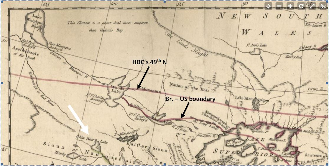
Oswald’s map displays three distinct manuscript additions related to HBC territory. Firstly, there’s a manuscriptblue and red line that runs bold and straight, originating near Lake Abitibis (sic) and extending westward along the 49 degrees North parallel (see Reference Points map MS – 1) traversing the southern tip of Lake of the Woods and continuing due west beyond.[10] Secondly, there’s a handwritten notation in red ink just above the 49th stating “Boundary between the Lands granted to the Hudson’s Bay Company and the Province of Quebec” (see MS – 4). Any claim the Quebec Act of 1774 designated the 49th N as the HBC’s southern limit is unfounded. The act briefly mentions the HBC in relation to the expanded province of Quebec, which was described in part as extending “Southward to the Banks of the Mississippi and Northward to the Southern Boundary of the Territory granted to the Merchants Adventurers of England, trading to Hudson’s Bay [HBC].”[11] The bi-colored line boldly partitions some of the HBC’s southern territory near the 49th from the recently expanded authority of Quebec province. Lastly, there’s a red ink annotation that reads “An Erroneous Line” placed beneath Mitchell’s 1755 height of land, broken black line (highlighted in red and yellow) boundary (see MS – 2 and 3). It historically identified the HBC’s guesstimated charter boundary. Collectively these manuscript alterations highlight Whitehall’s intent to ensure Commissioner Oswald understood that Mitchell’s fragmented black line was no longer considered the southern boundary of the HBC.

The HBC had long term concerns about the loss of parts of its southern and western frontier lands. In 1719 the British unsuccessfully negotiated with France to have the 49th N recognized as the HBC’s definitive southern boundary. If its request had been granted, the company hoped it would reduce French raids from New France.[12] Later as the fate of New France was being negotiated in 1762, a second but failed company request for the 49th boundary was made to the British government.[13] Keeping the history and interests of the HBC in mind, it is probable that in summer 1782 Shelburne encouraged Oswald to avoid, if possible, involving any HBC land in a settlement with the Americans or France.
In August 1782 Franklin was incapacitated by a severe bout of gout. During Franklin’s illness, John Jay, the sole American negotiator, stressed the immediate need for accurate and high-quality maps of America. In response to Jay’s urgency, Oswald forwarded a request to London for “a complete set of the last and most extensive edition of maps depicting North America.”[14] It is likely Jay was particularly interested in obtaining recent maps like William Faden’s 1777 publication The British Colonies in North America.[15] Prior to arrival of the requested charts, Oswald and Franklin probably already had frequently consulted and drawn upon the former’s Mitchell map.[16]
By early October Jay, Franklin and Oswald successfully negotiated a northwestern boundary for the new republic, described in part as running: “due West in the Latitude forty-five Degrees North from the equator, to the Northwesternmost Side of the River St. Lawrence, or Cadaraquii, thence Straight to the South End of the Lake Nipissing, and thence Straight to the Source of the River Mississippi.”[17]Jay’s handwritten copy was the first draft of the articles of peace sent off to London.
![]()
Negotiators on all sides had earlier agreed to use the Mitchell map as their official reference plan.[21] Once the paper copy of the October preliminary was en route to England, the commissioners plotted interpretations of the new republic’s boundary on their respective copies of Mitchell’s map. A complication arose with the map due to the presence of a small overlay chart in its northwestern corner titled A New Map of Hudson’s Bay . . . . The presence of the insert made it impossible to draw that part of the line.
While attempting to approximate the source of the Mississippi, the commissioners’ resulting Nipissing lines were quite different. Jay’s representation on his Mitchell map shows a faint, wavy red northward extension of the river to his conjectured source, stopping just short of HBC territory, extrapolated latitude 49° N (see Jay’s source).[22] It seems that Jay’s estimate for the source was heavily influenced by Mitchell’s map note and probably by earlier discussions about the HBC’s southern limit.
For the British, Oswald had a plotting advantage as he was privy to Franklin’s personal acquaintance with Capt. Jonathan Carver, his northern Mississippi reconnaissance, maps, journals and recently published Travels book.[23] Carver had indicated the source of the Mississippi was significantly south of Lake of the Woods. Thus Oswald or Franklin added to Oswald’s map a short stout red line through the Strait of Belle Isle at the extreme right edge of the inset map to correspond with Carver’s source, extrapolated 47.6° N (see MS – 5).[24] Despite later being mostly erased, Oswald’s Nipissing line provides evidence that Franklin had probably earlier influenced him to use Carver’s source of the Mississippi.
Nevertheless the overall terms outlined in the initial preliminary peace agreement were met with rejection by Shelburne and his cabinet, and Oswald faced criticism for making what was perceived as overly generous concessions. To address this situation, Henry Strachey, a top cabinet official’s secretary, was promptly sent to Paris to assist Oswald in negotiating a more restrictive agreement with the Americans.[25]
Finally on November 30, 1782, the expanded joint commission reached a conclusive peace agreement. Richard Oswald, John Adams, John Jay, Henry Laurens, and with Benjamin Franklin’s reserved approval, jointly signed the Preliminary Articles of Peace.[26] The Americans had only partially incorporated their Second Continental Congress’s 1779 wishes for the northwestern boundary.[27] Congress had specified the line should start, in part from the intersection of the 45th N parallel and the St. Lawrence River and proceed directly to the southern end of Lake Nipissing and further to the source of the River Mississippi. Instead, the finalized northwest line, after reaching the St. Lawrence, continued westward through the center of the Great Lakes (excluding Michigan) and from the northwest shore of Lake Superior headed inland along a water and land trade route to the most northwestern part of Lake of the Woods. It was then to proceed due west until it intersected the conjectured Mississippi at a likely point south of 50° N.[28] The start of the due west line is shown on Oswald’s map (see MS – 9).
Reaching a consensus on the extreme northwest corner of the boundary posed difficulties for Franklin, since he had earlier maintained the river’s source was located south of Lake of the Woods.[29] However, to conclude the signing of the Preliminary Articles of Peace, Oswald and Franklin must have remained mute about Carver’s source of the Mississippi and acquiesced to the stance of their fellow commissioners and others who wished not to deviate from Mitchell’s authoritative, yet outdated and inaccurate river details. Ten months later the boundary as delineated in the Preliminary Articles of Peace was, word for word, ratified in the 1783 Definitive Treaty of Paris, Article Two.[30]
As shown on Oswald’s map, the extreme northwest boundary extending beyond Lake of the Woods (see MS – 9) granted the United States a narrow slice of the southern chartered wilderness claimed by the Hudson’s Bay Company. This strip of new American territory spanned roughly 0.5 degrees of latitude (see Reference Points map white bracket west of Lake of the Woods).[31]
British commissioner Richard Oswald concluded his duties in Paris and made his final return to London within two months of the peace agreement.[32] By early February 1783, he probably had submitted his working papers and map to the British government and held discussions with key cabinet members to review the terms of the peace. Prime Minister Shelburne and Secretary of State Thomas Townshend later visited George III to present the preliminary peace articles. Oswald’s annotated copy of the Mitchell map would have served as a valuable aid for understanding the borders of the newly established American republic. One notable feature on the map was the thin red line that mostly encircled the new nation and was clearly labeled as “The boundary as described by Mr. Oswald” (see MS – 7).[33] This annotation was added adjacent to the red line in twelve different locations on Oswald’s map. The incomplete extreme northwestern portion of the red boundary line would have raised concerns for the king and his cabinet.
George III would have ruminated over Oswald’s map, possibly spending days pondering its implications. The starting point of the extreme northwest boundary line extending due west from Lake of the Woods was unavoidably cut short due to the inset overlay, and the northernmost parts of the Mississippi River were unknown according to Mitchell’s map note. These uncertainties would undoubtedly have been matters of continuing concern for the king, his advisors, and Geographer to the King, William Faden. Oswald’s map remained part of the king’s extensive map collection in the West Library adjacent to his bedchamber in Buckingham Palace.[34]
A brief aside: Plans were devised in America and France to seize the HBC’s North American assets. In 1779 the American Naval Board approved an attack on the HBC’s Arctic forts.[35] However, due to more urgent defensive needs along their Atlantic coastline, no American naval action was undertaken in Hudson Bay. Meanwhile in France, Commodore Jean-Francois de Galaup, comte de La Perouse outlined in 1780 a comprehensive naval plan to the French royal court to expel the English from Hudson and James Bay.[36] His proposed strategy aimed to establish robust trading posts in the bay area, staffed by resilient French servants who would benefit from the earlier successes of the British company. Despite receiving royal endorsement, La Perouse’s plan remained dormant until August 1782. Then soldiers from his three armed warships, present in the bay, executed a surprise bloodless total destruction of two of the HBC’s largest and most profitable heavily armed bayside forts.[37] News of the complete obliteration of the forts reached Paris and London a few days before the closing negotiations and signing of the Preliminary Articles of Peace.[38]
Another key figure, Lt. William McMurray, who had served as the late Assistant Geographer to the United States, offered a meticulously researched map to subscribers in the summer of 1783 and publicly released it in December 1784. McMurray’s mapping of the northwest region also heavily relied on Captain Carver’s work. He depicted the “proposed limits of Hudson’s Bay” line converging in “L of y Woods” with the northwestern boundary of the United States. Interestingly, McMurray did not label British North America, the HBC’s limits west of Lake of the Woods, or the Mississippi as the republic’s western boundary.


Within a decade, John Jay’s 1794 treaty included recognition of the charter rights and lands of the HBC.[46] In the course of incomplete negotiations related to the international boundary in 1807, the HBC was asked by British Lords Auckland and Holland to substantiate its claim to the 49th N parallel boundary. After a careful search of the company’s extensive archives, HBC Deputy Governor William Mainwaring reported his staff could not find any government or royal document altering the company’s southern limits as established by its 1670 charter.[47] The U.S.–British Convention of 1818 established the 49th North parallel as the official international boundary from Lake of the Woods to the Rocky Mountains.[48]
Finally, the Hudson’s Bay Company was able to rightfully claim that portion of the 49o N parallel between Lake of the Woods and the Rockies as its southern limit.[49]
[1]British Library topographical catalog (Maps K.Top 118.49b). Complete title A Map of the British Colonies in North America, with the Roads, Distances, Limits, and Extent of the Settlements, Humbly Inscribed to the Right Honourable the Earl of Halifax and the other Right Honourables, the Lords Commissioners for Trade & Plantations. Also at Boston Public Library, Leventhal Digital Collection, A MAP of the BRITISH COLONIES in North America, collections.leventhalmap.org/search/commonwealth:hx11z549x. For a detailed review of the production history of Mitchell’s map see Matthew H. Edney, “A Publishing History of John Mitchell’s 1755 Map of North America,” Cartographic Perspectives, no. 58 (2007): 4-27 and 71-75.
[2]The HBC’s North American royal charter was granted by Charles II of England in 1670. It gave a small group of stock-holding merchants, traders, sea captains and a few Royals total control over a vast unknown wilderness drained by rivers flowing into Hudson Bay and Strait and James Bay. The HBC’s first royal governor was the king’s nephew, Prince Rupert. In 1782 George III held significant dividend-paying stock in the company. The company conducted its business in a very private and highly secretive manner. Often major HBC stockholders had powerful political connections. For example, Sir William Baker was a very successful British-American merchant and a highly regarded government advisor on North American affairs. He was a major stockholder and governor of the company from 1750 to 1770. His eldest, William Baker, Jr., 1743-1824, was a HBC committee man and a map savvy parliamentarian.
[3]Benjamin Franklin to the Comte de Vergennes, April 15, 1782, founders.archives.gov/documents/Franklin/01-37-02-0113. Oswald first met Franklin in Paris on April 15, 1782.
[4]Up to 1763 the HBC’s chartered territory and fur monopoly were continuously challenged by French soldiers and roving fur traders from Canada. After the fall of New France, swarms of mainly aggressive English and Scottish traders from Montreal totally ignored the company’s charter and penetrated deep into HBC territory.
[5]An accurate map of North America: describing and distinguishing the British, Spanish and French dominions, www.loc.gov/resource/g3300.ar002100/?r=0.174,0,0.274,0.109. Bowen was not the first British cartographer to incorrectly state the 1713 Treaty of Utrecht established the HBC’s southern limit.
[6]The 1713 Treaty of Utrecht, Article 10, required British and French commissioners to negotiate a boundary between HBC lands and New France. In 1719 the talks totally collapsed and no agreement was ever concluded about which nation controlled the vast territory south of Hudson and James Bay. In 1755 Mitchell identified New France (Canada) on his map as the territory (partly shaded pale yellow on Oswald’s copy) south of the HBC’s wavering height of land boundary. In 1756 German cartographer Le Rouge’s French reproduction of Mitchell’s map Amérique septentrionale avec les routes, distances en miles, villages et etablissements françois et anglois showed a contested boundary of Canada (see legend and bi-colored yellow and green line) extending along the 50th N parallel. www.loc.gov/resource/g3300.ar004700/?r=0.202,0.076,0.327,0.113,0. During the 1782 Paris negotiations, John Adams had his personal copy of Le Rouge’s atlas (purchased in Paris in 1780) featuring a full-size, French version of Mitchell’s map. Adams might have advantageously concluded that Le Rouge’s yellow and green line along the 50oN parallel was the southern limit of the HBC. Adams’s fully restored 1778 atlas Atlas Ameriquain Septentrional is archived in the John Adams Library, Boston Public Library.
[7]For the Patriots’ 1775-1776 attempts see G. Kotlik, “Phraseology and the Fourteenth State,” Journal of the American Revolution, August 4, 2021, allthingsliberty.com/2021/08/phraseology-and-the-fourteenth-colony/.For Franklin’s failed diplomatic mission see G. Procknow, “Franklin’s Failed Diplomatic Mission, Journal of the American Revolution, January 27, 2015, allthingsliberty.com/2015/01/franklins-failed-diplomatic-mission/.
[8]Franklin to Lafayette, July 9,1782, list (fourth item) of “advisable” parts of any peace agreement, https://founders.archives.gov/documents/Franklin/01-37-02-0387.
[9]After Mitchell’s map was reprinted circa 1775, two colors (pale yellow and light salmon) were used to distinguish lands purportedly controlled by the HBC from those governed by the province of Quebec.
[10]The red and blue bi-colored line along the 49oN and its handwritten identifier were added before the map went to Paris. Map specialists in Whitehall would have known the commonly accepted HBC boundary details, earlier treaty lines, etc., (see MS – 1 & 4). In the early 1700s a HBC survey determined the 49th N parallel crossed near the height of land on the commonly used water and land route between New France and the HBC’s bayside trading factories.
[11]Great Britain: Parliament – The Quebec Act: October 7, 1774, Part I, avalon.law.yale.edu/18th_century/quebec_act_1774.asp.
[12]Labrador Boundary Dispute Documentation, Privy Council Notes – Dominion of Canada – Boundary of Labrador,Instructions to Commissary Bladen, November 1719, No. 1538, (PDF page 5208), www.heritage.nf.ca/articles/politics/privy-council-introduction.php.
[13]Ibid.For the HBC’s repeat boundary request and damage claim against the French for upwards of 100 000 pounds see Memorial of the Hudson’s Bay Company to Lords Commissioners of Trade, October 3, 1750, No. 4095, page 5229. Also see Extracts from Minutes of the Committee of the Hudson’s Bay Company, September 6, 1762, No. 1556 (PDF page 5245). See also Secretary Hudson’s Bay Company to Earl of Egremont, Secretary of State, March 23, 1763, No. 1557 (PDF page 5246). Shelburne served as President of the Board of Trade from April to September 1763. This board advised the king and his secretaries of state. Shelburne was chosen to replace Egremont who died unexpectedly on August 21, 1763.
[14]Edney, Matthew, Essay IV, Mitchell’s maps used in Paris, 1782, oshermaps.org/special-map-exhibits/the-mitchell-map-1755-1782-an-irony-of-empire/iv-the-mitchell-map-in-paris.
[15]William Faden’s 1777 parent map The British Colonies in North America, collections.library.yale.edu/catalog/15604260.
[16]Merv O. Ahrens, “The Impact of Jonathan Carver’s Journal and Maps,” Journal of the American Revolution, March 23, 2015, allthingsliberty.com/2015/03/the-impact-of-jonathan-carvers-journal-and-maps. The manuscript dark red enhancement (see MS – 8) was added to the northern Mississippi River to possibly mark a second source of the river.
[17]Preliminary Articles – First draft, October 5-8, 1782, Part 1, 2nd paragraph, founders.archives.gov/documents/Jay/01-03-02-0059.
[18]Mathematician Samuel Dunn in 1776 and cartographer William Faden in 1777 published maps showing Captain Carver’s White Bear Lake as the source of the Mississippi. Library of Congress,The British Colonies in North America,www.loc.gov/resource/g3300m.gar00002/?sp=3&st=image.
[19]For an enlargeable copy of George III’s red-lined map (Oswald’s map) see Boston Public Library, Leventhal digital map collection, A MAP of the BRITISH COLONIES in North America, collections.leventhalmap.org/search/commonwealth:hx11z549x. Using high magnification, traces of Oswald’s (Franklin’s) Nipissing line can be seen running between Strait of Belle Isle (see inset map) and Lake Nipissing. See (MS – 5& 6) showing Oswald’s mostly erased Mississippi source and northwest part of his Nipissing line.See Note 16 for an enhancement of Oswald’s mostly erased Nipissing line.
[20]Preliminary Articles of Peace: First Draft Treaty, (October 5-7, 1782), founders.archives.gov/documents/Franklin/01-38-02-0143.
[21]John Adams, Deposition regarding Mitchell’s Map, 1796,founders.archives.gov/documents/Adams/99-02-02-1816. No map was attached to the final peace treaty.
[22]See also Mr. Mitchell’s Muscular Map,www.nyhistory.org/blogs/mr-mitchells-muscular-map.
[23]John Parker, ed., The Journals of Jonathan Carver and Related Documents 1766-1770 (St. Paul: Minnesota Historical Society Press, 1976). Carver’s manuscript maps and journals are in the British Library, London.
[24]Carver identified White Bear Lake, latitude 47.6o N, as the source of the Mississippi River. Nearby Lake Itasca, latitude 47.2oN, is now considered the river’s source.
[25]John Jay’s Diary of the Peacemaking, October 12 – 29, 1782,founders.archives.gov/documents/Jay/01-03-02-0062.
[26]Henry Laurens, the 4th American peace commissioner, arrived in Paris on November 28, 1782. See Preliminary Articles of Peace, (Nov. 30, 1782), founders.archives.gov/documents/Franklin/01-38-02-0286.
[27]Autobiography of John Adams, September and October 1779, founders.archives.gov/documents/Adams/01-04-02-0002-0001.
[28]Preliminary Article of Peace (November 30, 1782), Article 2, founders.archives.gov/documents/Franklin/01-38-02-02867.
[29]Captain Carver had impressed Franklin when they met in London in 1769. Franklin later viewed Carver’s manuscript map, journal, and his book Travels through the Interior Parts of North-America in the Years 1766, 1767 and 1768 (3rd edition, London, 1781) for details on the source of the Mississippi. Carver’s book repeated the geography of this route and illustrated it on an accompanying map, A Plan of Captain Carver’s Travels in the interior Parts of North America in 1766 and 1767. Franklin was likely the “detail person” for the Lake Superior to Lake of the Woods boundary. Both Mitchell’s and Carver’s maps show Lake of the Woods as a simple “roundish” lake with a few islands. In reality its shoreline length is about 65,000 miles with over 14,000 islands. It took over sixty years for British and American surveyors to agree upon the most northwestern point of the lake located at the extreme northwest end of Angle Inlet, Lake of the Woods.
[30]Treaty of Paris, Sept. 3, 1783, Part of Article 2: “thence through Lake Superior . . . to the Long Lake (now identified as the mouth of Pigeon River, MN); Thence through the middle of said Long Lake and the Water Communication between it & the Lake of the Woods, to the said Lake of the Woods; Thence through the said Lake to the most Northwestern Point thereof, and from thence on a due West Course to the river Mississippi.”www.archives.gov/milestone-documents/treaty-of-paris.
[31]The 0.5o and white bracket on the Reference Points map identifies the Americans’ portion of HBC chartered land south of the boundary line claimed by the United States.
[32]Franklin to John Adams, January 19, 1783, founders.archives.gov/documents/Franklin/01-38-02-0454. Oswald returned to London about the end of January 1783. His health was beginning to fail.
[33]This red ink notation (seeMS – 7) plus eleven more were authored by one of three individuals: Thomas Townshend (most likely), Shelburne or Oswald. A handwriting comparison eliminates George III as the writer. Presumably this set of notations was completed soon after Oswald and his map returned to London in early 1783. Immediately after the manuscriptred ink boundary line enters Lake of the Woods(overlaying a black pencil line) it crosses the bi-colored 49th N and penetrates HBC territory. Thisline continues north through Lake of the Woodsand then west through company territory until it intersects the conjectured Mississippi near the 50th N parallel (according to Mitchell’s map note).
[34]Mapping the Georgian world: global power and maps in the reign of George III by retired British Library map curator Peter Barber.www.youtube.com/watch?v=5BYTOHxr_80.
[35]George Washington to Bartholomew Dandridge, December 18, 1782, founders.archives.gov/documents/Washington/99-01-02-10234.
[36]“Plan for the Expedition to Hudson Bay” by Jean-Francois Galaup, Comte de Lapérouse: A Newly Discovered Manuscript, Manitoba Historical Society,www.mhs.mb.ca/docs/mb_history/52/laperousemanuscript.shtml.
[37]Merv O. Ahrens, “Revolutionary Revenge on the Bay,” Journal of the American Revolution, May 7, 2020, allthingsliberty.com/2020/05/revolutionary-revenge-on-hudson-bay-1782/.
[38]Ibid. La Perouse’s warship put into port at Cadiz, Spain on October 10, 1782. News of the French navy’s success in Hudson Bay would have reached London and Paris shortly thereafter.
[39]The United States of North America, with the British & Spanish territories according to the treaty, www.loc.gov/item/2002621132.
[40]Ibid. Faden’s explanatory note is midway down the right side of his map.
[41]A new and correct map of the United States of North America: layd down from the latest observations and best authorities agreeable to the Peace of 1783: humbly inscribed to his excellency the Governor and Company of the state of Connecticut / by their most obedient and very humble servant Abel Buell, www.loc.gov/rr/geogmap/buellmap.html.
[42]The northwest portion of McMurray’s inset map is a small part of The United States according to the definitive treaty of peace signed at Paris Sept. 3d. 1783, www.loc.gov/item/gm71005423.
[43]Faden’s 1785 map The United States of North America, with the British & Spanish territories according to the treaty of 1784,www.loc.gov/item/73691860/.
[45]See Reference Points (MS – 1 to MS – 9)map. The white bracket identifies 0.5oof latitude encroachment on the HBC’s limits.
[46]Jay’s Treaty, Article 3 “(the Country within the Limits of the Hudson’s Bay Company only excepted),” avalon.law.yale.edu/18th_century/jay.asp.
[47]Mainwaring to Lords Auckland and Holland, March 24, 1807, Hudson’s Bay Company Archives, Winnipeg, MB, Canada.
[48]Avalon Law, Convention of 1818, Article 2, avalon.law.yale.edu/19th_century/conv1818.asp
[49]British Lord Selkirk, a North American colonizer, lost his claim to the upper Red River (of the North) basin south of the 49th parallel. President Thomas Jefferson’s purchase of the Louisiana Territory in 1803 made Selkirk’s ownership invalid.

Recent Articles
Two Short Notes on The Federalist no. 9 and no. 62
Timothy Matlack, Scribe of the Declaration of Independence
Declarations Before THE Declaration of Independence
Recent Comments
"Admiral Rodney Ousts the..."
I wrote extensively on this episode in Guido Abbattista (University of Trieste,...
"Black Soldiers of Liberty"
Somehow I missed Paul's List of Free African Americans in the American...
"The 25 Deadliest Battles..."
The ranking is based entirely on America casualties, the numbers in bold.