

The Frenchman’s map of Williamsburg, Virginia served as a significant source for the restoration of Colonial Williamsburg. It indicated potential archaeological sites and served as a base for Dr. William Archer Rutherfoord Goodwin’s survey in 1927. The final draft of the map seems to be lost forever but a fine copy (see fig. 1) measuring 55 cm. x 68 cm. is housed in the Special Collections Research Center of the Swem Library at the College of William & Mary.[1] There is no indication as to who the cartographer might have been.

The map is unsigned but the legend in the lower left is written in French. Hence, it has been called “the Frenchman’s Map.” It is dated May 11, 1782. So what brought the French to Williamsburg? And what occurred at that time that necessitated such a detailed map?
Lt. Gen. Jean Baptiste Donatien de Vimeur Comte de Rochambeau came to America with an army of about 6,100 men on July 11, 1780. He and Gen. George Washington learned that British troops withdrew to Yorktown in August 1781, and that Admiral François Joseph Paul Comte de Grasse would sail no farther north than the Chesapeake Bay. De Grasse planned to return to the West Indies by mid-October to avoid being caught in possible hurricanes. So Washington and Rochambeau decided to march south.
Washington’s army arrived at Williamsburg, the rendezvous point, and camped on September 23, 1781. The French troops arrived and camped on the 26th. The allied army composed of 5,000 Americans of the Continental Army, 1,200 Virginia militiamen and 8,000 French then marched for the siege of York at dawn on the 28th.
The Map’s Purpose
After the British surrendered at Yorktown, the French army returned to Williamsburg where they remained until July 1, 1782. One assumption about the Frenchman’s Map is that it was made for the billeting of French troops during the winter following the surrender of Yorktown. That is not likely. The map is dated May 11, 1782. Plans for billeting the troops would have been made in the autumn, before the cold weather, not in May, two months before their departure and when the weather becomes warm.[2] The map must have been created for another reason. Maybe it was meant as a souvenir of Rochambeau’s sojourn in Williamsburg. We may never know.
The Cartographer
As for the cartographer, mapmaking was one of the tasks of the corps of enginneers which included Col. Jean Nicolas Desandrouins, Rochambeau’s chief of artillery. He, however, did not participate in the Yorktown campaign due to illness and his papers were lost at sea in a shipwreck. Chevalier Thomas Antoine de Mauduit du Plessis, captain of artillery and regimental adjutant of artillery, does not seem to have left any papers, nor did Charles Joseph Antoine Soalhat (or Soualhat) de Fontalard, Baron de Turpin or any of the other artillerists.[3] None of the two hundred French volunteers who were commissioned by Congress as engineers in the Continental Army would have drawn the map, as they all marched north with the army in 1781.[4]
Most of Rochambeau’s aides-de-camp were graduates of L’École du Génie (School of Engineering) at Mézières. One of these aides was Louis Alexandre Berthier, who was also Rochambeau’s cartographer. Many of his maps are included in The American Campaigns of Rochambeau’s Army 1780, 1781, 1782, 1783 along with his diary.[5] Pierre-François de Béville was Rochambeau’s maréchal général de logis (quartermaster general) and maréchal de camp (camp marshal), but we have no extant documents of him. Of all his assistants, only three kept journals: Louis Alexandre Berthier, Mathieu Dumas and Louis François Bertrand Dupont d’Aubevoye, comte de Lauberdière.[6]
Quartermasters in the eighteenth century did not only administer food, clothing and equipment. They also took care of laying out a camp, planning routes of travel and making sure roads were in good condition. On the march to Yorktown, each regiment had an assistant quartermaster. Donatien-Marie-Joseph de Vimeur, vicomte de Rochambeau accompanied the Bourbonnais regiment; Alexandre-Théodore-Victor, comte de Lameth marched with the Royal Royal Deux Ponts regiment; Georges Henri Victor Collot went with the Soissonnais regiment; Louis Alexandre Berthier assisted the Saintonge regiment; Mathieu Dumas travelled with Lauzun’s Legion; Hans Axel, comte de Fersen attended the Royal Deux Ponts dragoons while Jacques Anne Joseph le Prestre, comte de Vauban went with the Chartres dragoons and Louis François Bertrand Dupont d’Aubevoye, comte de Lauberdière supported the Royal Normandie cavalerie.

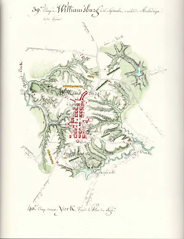
We know that Louis Alexandre Berthier mapped the camps and the route of march. His map of camp number 39 at Williamsburg (see fig. 2) shows where the troops camped on September 26 and 27, 1781. It is very different from the Frenchman’s map (fig. 1) which was drawn eight months later.
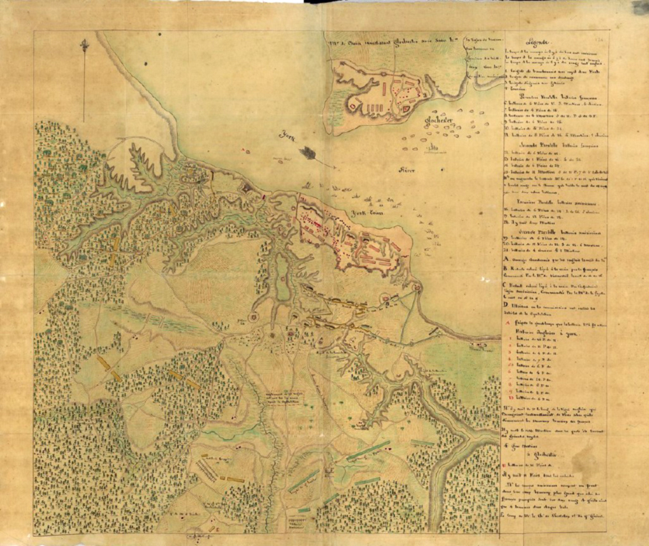
Louis François Bertrand Dupont d’Aubevoye, comte de Lauberdière, besides being one of Rochambeau’s aides and quartermasters, was also the general’s nephew. His Journal de l’armée aux ordres de Monsieur le Comte de Rochambeau pendant les Campagnes de 1780, 1781, 1782, 1783, dans l’amérique septentrionale includes several maps of the route of march.[7] While it does not include a map of Williamsburg, it does include one of Yorktown and Gloucester (see fig. 3). Comparing the features of this map with those of the Frenchman’s map reveals many similarities in style, particularly the buildings and river banks. These similarities suggest that the Count de Lauberdière may have been the cartographer of the Frenchman’s map. The script in the map’s legend does not match the script in Lauberdière’s diary, but the person who wrote the legend was probably not the one who drew the map. Historian Michael Lombardi notes that there is evidence of three different people who wrote on the Frenchman’s map.[8]
While the Count de Lauberdière may have been the cartographer of the Frenchman’s map, the true identity of the author and the purpose of the map may may never be known. We hope that this article lends some important detail to this discussion.

[1] Collection identifier Mss. Acc. 2009.002-Mss. Acc. 2011.536-Mss. Acc. 2013.184
[2] The British Parliament voted that there be no further offensive operations in Norh America in February of 1782. This would not have been known in America until April at the earliest. Such an action by the Parliament may have been the sign Washington was looking for before determining the disposition of Rochambeau’s army.
[3] The officers of the Second Battalion of the Auxonne Artillery Regiment included: Lieutenant-Colonels Jean-Pierre Goulet de la Tour, Antoine-Xavier de Nadal, Guillaume Cuirol de Laziers, Chevalier Jacques-Nicolas Catherine de Buzelet, Jean-Marie-André De Capriol de Saint-Hilaire; Captains Henry-Emery Chevalier de Boisloge, Jean-Baptiste De Morcourt de Foy, Bernard de Neurisse, Philippe de Rumigny, François Olivier d’Hemery, François-Justin Josserand, Chevalier Etienne Dupuy, Pierre Garret de Maisonneuve, Jean-Baptiste Bonnay de la Rouvrelle, Paul Alexandre-François-Xavier de Monginot, Floxel-Henry du Saussay de Greville, Nicolas Barthelemy, Guillaume Boivin de la Martiniere, Charles-Arnould-Ignace de Jumecourt, Claude-Hubert de Rouyer, Jean-Charles-François-Gabriel Daubert, Jacques François-Alphonse Pilotte de la Barolliere, Denis de Cremilles; Lieutenants Jean-Philippe Tardy de la Brossy, Philippe de Fouchet la Garrigue, Louis-Georges Mollet de Bregeot, Jean François Louis Comte de Clermont Crevecoeur, Michel-Benoit Comte de Charbonnel, François-Joseph-Donatien Grivel de Viley, François-Augustin Chevalier de Berlier, Augustin-Jean-Jacques de Sance, Alexandre-César De Genevy de Pusignan, Philippe François-Roch de Vasservas, Chevalier Louis De Ruffet de Saint-Martin, Joseph François Dalmas de Pracontal, Chevalier Jean Borthon de la Motte, Chevalier Jean de Thiballier, Jacques-Philippe de Verton, Jean-Baptiste Eble, Louis-Emile, Jean-Baptiste Faguette, Jean-Pierre Boulogne, Jean- François Gillet, Charles Martraire, François Berthier, François Doue, Bernard Lefebvre de Vulmont, d’Altecau, Thomassin, Dervieux, De Meaux, La Romagere, Parison and Sicard.
The officers of the Second Battalion of the Metz Artillery Regiment included: Lieutenant-Colonel Pierre Chevalier De Gimel; Chefs De Brigade Jacques Chevalier Saint-Michel de Missolz, Charles Joseph Abel La Barre de Carroy; Captains Joseph Durand, Pierre-Alexis Rotalier, Jean-François Tardy de Montravel, Pierre-Henry Chevalier Lefebvre de Vulmont, Louis-François Pelletier de Glatigny, Etienne Chevalier Dupuy, Gabriel-Joseph-Augustin-Laurent Pelletier d’Argers, Chevalier Jean Baptiste Maugin Douence, Modeste-Joseph de Watry, Jean-Baptiste Ollivier, Albert-Louis de Douay, Claude-François Ignace Durand de Gevigney; Lieutenants Michel Benoit Comte de Charbonnel de Jussac, René Antoine Drozain, Jacques-Joachim-Louis Leblanc d’Ecquilley, Charles-Louis-Didier de Songis, Paul Guy de Gimel, François-Gilbert Chassain de Marsilly, Benoit-François de Vaurion, Honoré Caillere Duglacis, François Le Duchat Daubigny, Antoine-Jacques de Caussanel, René Marguerite-Henry de Neufvy, Jean-Louis-Alexandre de Ridonet de Sauce, Jean-Baptiste-Vincent Chevalier Durand, Joachim-Jacques-Philippe Chevalier De Faultrler, André de Mestre, François Aubert Chevalier de Peyrelongue, Jean Vernier, Jean-Paul Vernier, Jean-Claude Goffart, Jacques Pecqueux, Jean Gervais and Simon Duroz.
[4] Arthur S Lefkowitz and Norman Desmarais, George Washington’s Dilemma: Commanding an Army in the American Revolution that Included Hundreds of French Patriots, Adventurers, and Pretentious Imposters (Revolutionary Imprints, 2026).
[5] Howard C. Rice, Jr. and Anne S. K. Brown. The American Campaigns of Rochambeau’s Army 1780, 1781, 1782, 1783 (Princeton University Press, Brown University Press, 1972), vol. 2.
[6] Rice and Brown, The American Campaigns, vol. 1. Mathieu Dumas et al., Souvenirs Du Lieutenant Général Comte Matthieu Dumas, De 1770 a 1836 (Librairie De Charles Gosselin, 1839). Mathieu Dumas, Memoirs of his own Time; Including the Revolution, the Empire, and the Restoration (Richard Bentley, 1839). Journal of a French Quartermaster on the March to Yorktown June 16—October 6, 1781, translated and annotated by Norman Desmarais (Revolutionary Imprints, 2022). Louis François Bertrand Dupont d’Aubevoye Comte de Lauberdière, The Road to Yorktown: The French Campaigns in the American Revolution, 1780-1783 (Savas Beatie, 2020).
[7] Lauberdière, The Road to Yorktown.
[8] Michael J. Lombardi, “In Search of the Frenchman’s Map,” Colonial Williamsburg 29:4 (Autumn 2007), 20-25.

Recent Articles
Authorship of The Frenchman’s Map of Williamsburg
The Rise and Fall of Captain John Manley
Remembering the Revolution: Little Compton, Rhode Island
Recent Comments
"The Rise and Fall..."
It is great to have such a detailed account of John Manley's...
"Payback: Attack on the..."
Thank you all for your kind words. I was very lucky in...
"Payback: Attack on the..."
Joseph Orchard, how fun! Oliver DeLancey avoided having the property confiscated, and...