



The Battle of Cowpens, fought on January 17, 1781, in South Carolina, was one of the most significant American victories in the War for Independence. At a relatively low cost in casualties, the Americans destroyed the light troops of the British southern army, which not only weakened British control of South Carolina but more importantly, caused Lt. Gen. Charles, Earl Cornwallis, to set off in an unsuccessful pursuit of the retreating Americans that ultimately led to his surrender at Yorktown, Virginia, ten months later. For more than two centuries, the site of the battle has been referred to as “Hannah’s Cowpens” by nearly every historian who wrote about the battle, as well as by the National Park Service, which manages Cowpens National Battlefield Park. A careful examination of the original reference to “Hannah” and land records for northwestern South Carolina reveals that while there was indeed a “Hannah’s Cowpens,” it was located approximately eleven miles east-southeast of the cow pens where the battle was fought.
Since the name “Hannah’s Cowpens” was first applied to the Cowpens battlefield, few have questioned its accuracy. One of the first historians to examine the name, Lyman C. Draper, did not mention “Hannah” in his exhaustively researched 1881 account of the Battle of Kings Mountain; Draper mentioned the cowpens because Americans used the location as a staging point on their way to the 1780 battle. “For an hour or two on the evening of [October] the sixth, there was a stirring bivouac at the Cowpens,” Draper wrote. “A wealthy English Tory, named Saunders, resided there, who reared large numbers of cattle, and having many pens in which to herd his stock—hence the derivation of Cow-pens.” The Americans allegedly dragged Saunders from his bed, as he was sick or pretending to be, and demanded information about British movements, which Saunders would or could not provide. “Several of the old Tory’s cattle were quickly shot down and slaughtered for the supply of the hungry soldiers,” Draper stated. He listed the narratives of Capt. David Vance and McDowell, in the possession of the late Capt. Robert Henry, as his sources of information on Saunders, though he probably meant Vance’s and Henry’s accounts, as neither Charles nor Joseph McDowell composed a narrative on Kings Mountain.[1]
In fact, Vance did not mention Saunders in his account, but Silas McBee, who Draper listed as the source for the killing of the cattle, did. In an interview with Draper, McBee recalled that the Americans “late in the evening of the 6th of October reached the Cowpens, where lived a noted Tory, an Englishman of the name of Saunders, and his ungathered corn crop of perhaps 50 acres was harvested in about 10 minutes; and some of his beeves were killed and roasted. Here at the Cowpens, a fine range along a hill, the army lay an hour to refresh.”[2] The hill to which McBee referred was Thicketty Mountain.
In the official National Park Service handbook “Downright Fighting”: The Story of Cowpens, author Thomas J. Fleming speculated that the site “was probably squatters’ ground though one tradition says that it belonged to a person named Hannah, while another credits it to one Hiram Saunders, a wealthy loyalist who lived close by.”[3] Fleming did not cite a source for this statement. National Park Service Chief Historian Edwin C. Bearss investigated the name in his book on Cowpens and concluded that “Hannah’s Cowpens” was indeed the correct name, citing a 1954 article by Hugh F. Rankin, who described “Hannah’s Cowpens” as “a former trading post.” Rankin cited William Johnson’s 1822 biography of General Nathanael Greene as the source of the information.[4]

In an earlier work, a Historic Grounds and Resource Study of the battlefield, Bearss also attributed ownership of the cowpens to Hannah, though in this case he cited a volume by North Callahan as his source. Callahan wrote that the location was “called Hannah’s Cowpens from the name of the man who grazed his cattle there.” Like Rankin, Callahan found this information in Johnson’s work.[5] Later in his study, in a section entitled “The Origin of the Name,” Bearss noted that “no effort was made to trace the source of this name [Hannah’s Cowpens] until 1822,” and credited Johnson with the discovery. Bearss added,
a review of the South Carolina State Grant and Plat Books, and of the Tryon and Spartanburg Counties Plat and Deed Books failed to identify any legal instruments or documents indicating that a person named Hannah owned land in and about the Cowpens. If there was a Hannah in the area, he established himself as a squatter, a situation not infrequent in a frontier area such as this was in the 1770s.
Bearss concluded that “the battle . . . took its name from the locality, and all contemporary sources refer to the area as the Cowpens.”[6]
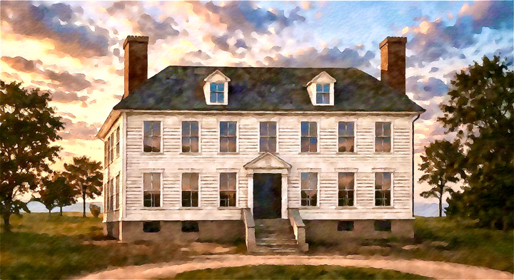
As Bearss indicated, the roots of the name “Hannah’s Cowpens” all trace back to William Johnson. Born in present-day Berkeley County, South Carolina, Johnson studied law after his graduation from Princeton University and worked as an attorney and judge before Thomas Jefferson appointed him to the United States Supreme Court in 1804. In 1808, Johnson built a house on Rutledge Street in Charleston. In his two-volume, 1822 biography of Nathanael Greene, Johnson observed in a footnote that

the place of this memorable event the Cowpens battle has now lost its name, but no American will reflect with indifference on the possibility of its identity ever becoming doubtful. The following remarks may direct the researches of some future traveller or historian. At the first settlement of that country, it was a place of considerable notoriety from a trading path with the Cherokees which passed by it.[7]
Johnson added,
in the early grants of land in that neighborhood it is distinguished by the epithet of Hannah’s Cowpens, being the grazing establishment of a man of the name of Hannah. In time it became known by the epithet of the Cowpens, and is now distinguished as attached to Nesbit’s iron works, the property of the honourable Wilson Nesbit.[8]
Johnson cited no sources for this conclusion and there is no evidence he ever traveled to the backcountry to obtain information. The most likely explanation for Johnson’s assertion is that he learned of it from fellow Charlestonian William Hort, the South Carolina state treasurer who along with his wife Alice Gibbs Hort, daughter of another prominent Charleston family, moved in the same social circle as Johnson.

Hort owned a 1,250-acre tract in the backcountry less than one-half mile from plats owned by Vardry McBee, father of Silas McBee who later provided information to Draper. Hort knew McBee, as he later sold him his acreage. Both Vardry and Silas McBee, as will be seen, were intimately acquainted with Hannah’s Cowpens, and knew it was not the location of the battle. Perhaps Johnson assumed that Hort’s (or someone else’s) mention of Hannah’s Cowpens referred to the battlefield, but no matter how he came to believe that, he was mistaken, and his error has been perpetuated for two centuries.
Tracing the History of the Battle Site
The first mention of a cowpens on the site of the battle dates to 1767 and can be found in North Carolina records. This was the result of an error in marking the boundary between the two Carolinas, which led to North Carolina colonial officials believing they controlled territory that actually belonged to South Carolina. On May 6, 1769, North Carolina granted two hundred acres of land to Daniel McDaniel. The parcel was described as “on Suck Creek of Broad river including his improvement,” indicating that McDaniel was already living there (occasionally the name is misread as “Lick Creek”).[9] The warrant for this tract was issued to McDaniel on October 20, the same day a separate warrant was issued for his four-hundred-acre tract nearby, and included additional details in the category “Situation of the land”: “On the w[es]t. side of Broad river, Includg. his own improvement an Cow pens on Suck Creek.”[10] McDaniel’s land was well-suited for cattle, as one of their preferred food sources was the tender peavine leaves that grew abundantly at the creek’s headwaters.
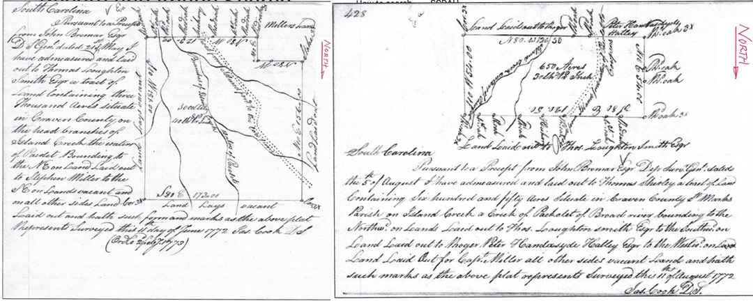
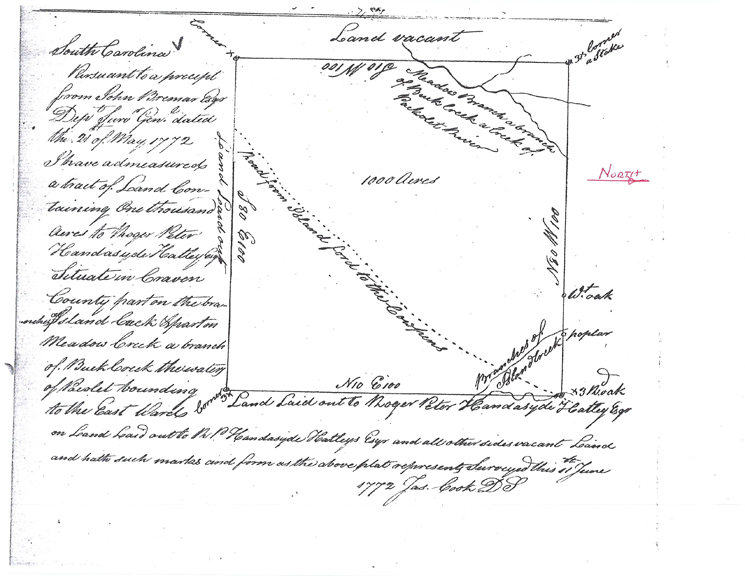
On June 4, 1772, a revised boundary between North and South Carolina was approved by the latter. James Cook, who had been South Carolina’s chief surveyor when the boundary was redrawn, then surveyed several plats south of McDaniels’s land. Among these were the adjoining parcels of Roger Peter Handyside Hatley, 1,000 acres, and Thomas Loughton Smith’s 3,000 acres, both surveyed on June 11, and Thomas Shirley’s 650 acres, surveyed on August 11. All three plats showed a road leading roughly northward from Island Ford on the Pacolet River. On each map, the route was labeled “road from Island Ford on the Pacolet to the Cowpens.” It led to the McDaniel tract. This was the route that Lt. Col. Banastre Tarleton’s British detachment followed on its march to battle at Cowpens.[11]
Two additional surveys of adjacent properties, one conducted in 1785 and the other in 1793, labeled the cowpens property as “Daniel McDaniel tract.”[12] There is no evidence that these cowpens were named after McDaniel; they were known simply as “the Cowpens.” The association of the Saunders name with them, in addition to the statement by Silas McBee, can be found in the pension application of Joseph James, a veteran of the Battle of Cowpens. James testified that “he was left for dead after a sword [wound] on his head, and broken ribs loose from his backbone, probably from the horse of the Dragoon. After the battle he was carried to a Mr. Saunder’s house. Other wounded persons were also left at the same house.”[13] So there very likely was a Saunders living at or near these cowpens, but he was almost certainly the pens keeper, not the owner of the property.
Daniel McDaniel (1723-1797), a native of Inverness, Scotland, had settled in South Carolina by 1745 when he married Rebecca Middleton. In 1752 he owned a five-hundred-acre grant on the Wateree River in Camden, then called Pine Tree Hill. He was a planter and a land speculator, and acquired a large plantation on the east bank of Fishing Creek, below the Catawba River in present-day Lancaster County. During the Revolution, his two sons fought for the Americans, and eventually he, too, took up arms despite being middle-aged.[14]
McDaniel’s original two-hundred-acre grant was sold at an unknown time to Shadrack Nolan, who in turn sold it to Edward Williams in December 1787. Nolan, of Fairfield County, was probably an acquaintance of John Woodward, Sr., who married McDaniel’s daughter Esther, also resided in Fairfield County, and may have hired Nolan as a pen-keeper. Woodward also came into possession of four hundred acres that had been granted to McDaniel on December 10, 1769. This tract was part of the extensive cowpens and Woodward possibly acted as a manager and perhaps co-owner of the cowpens.[15]
What of Hannah’s Cowpens?
Having established that the Battle of Cowpens was fought on the property owned by Daniel McDaniel, the question then arises: Was Hannah’s Cowpens a real place? And if so, where was it located? The trail leads back to none other than Silas McBee. The reason that he never referred to the battlefield as “Hannah’s Cowpens” was simple. His family owned that property, and Hannah was his mother.
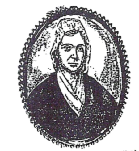
Silas’s father, Vardry McBee, owned several properties in the backcountry, three of them on Thicketty Creek. A deputy surveyor for the colonial government, McBee used his knowledge of the backcountry to speculate in land there. He was notorious for using the courts to protect and expand his holdings, repeatedly suing owners of adjacent properties for infringing on his land.[16] In addition to his surveying work, McBee operated a store on his three-hundred-acre property located at the headwaters of People’s and Limestone creeks on the site of present-day Limestone University. McBee and his wife Hannah acquired that property from Adlai Osborne, the clerk of court in Tryon County, and added another 140 acres by means of a successful lawsuit against his neighbor to the south, Robert Loony.[17] McBee also quarried limestone and built furnaces for an ironworks. Yet these were not his only business operations. Taking advantage of abundant water and the excellent grazing conditions at the headwaters of the creeks that flowed across his property, McBee raised cattle. Because he had so many enterprises to manage and had to leave for long periods to take cattle, ponies, and ironware to Charlestown or Augusta to be sold, returning with thoroughbred horses and goods such as ammunition, rice, salt, and sugar to sell at his store, McBee left the day-to-day management of the cowpens to his wife, Hannah Echols McBee. Hence, they became known as “Hannah’s Cowpens.”[18]
References to Hannah’s Cowpens were first made by another deputy surveyor for South Carolina’s colonial government, William Downes. He used it as a locator when surveying two plats for R. P. H. Hatley, recording on August 26, 1772 that the lots were “7 miles below George Blanton, on a ridge from Hannah’s Cowpens to Cherokee Ford.” The following month, Downes again used the McBee cowpens as a locator for two plats on Thicketty Creek owned by Thomas Elfe and William Burrows, describing them as “three miles below Hannah’s Cowpens and eight miles above Nathan Jefferies.”[19] After the Revolution, McBee fell upon hard times as paper currency had lost most of its value and the crops failed on several of his properties. Unable to repay debts to Francis Bremar, the new state government’s surveyor general and a fellow land speculator, McBee was forced to turn over several tracts to reduce the amount he owed Bremar. Finally, on November 8, 1788, McBee signed an indenture to Bremar using the cowpens property as security. The indenture specified the collateral was “that plantation or tract of three, 300 acres of Land Situate on the head of Millers Fork of Thicketty [Creek] including Hannah’s Cowpens, and the Lime Quar[r]y which was purchased of Col. Adley Osborn of North Carolina by the said Vardry McBee and which the said Vardry McBee now lives upon.” On October 22, 1802, the indenture was converted to a mortgage. Unfortunately for McBee, Bremar had exhausted his funds through speculation and became insolvent, so he could not provide money to McBee, who ultimately lost title to the property.[20]
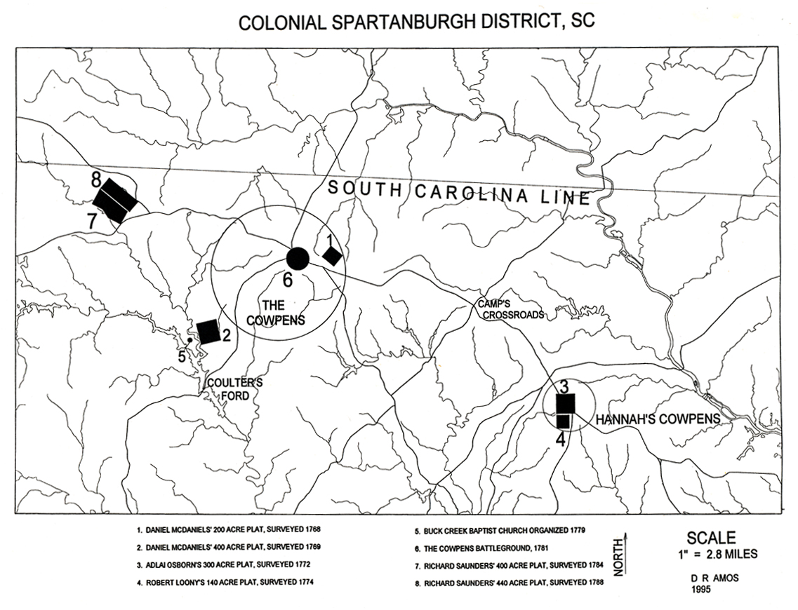
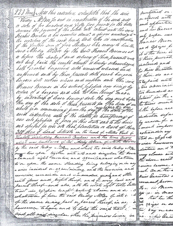
There were over twenty cowpens in South Carolina in the late colonial/Revolutionary era, and twenty of them were named, among them Howell’s Cowpens in present Fairfield County that was also managed by a woman. Evidence from eighteenth-century property transactions clearly demonstrates that there were two cowpens in the area of the Cowpens battlefield, one owned by Daniel McDaniel and known simply as “the Cowpens” (the only one found that went unnamed) and the other owned by Vardry McBee and tended by his wife Hannah, and known as “Hannah’s Cowpens.” Careful mapping of the plats and transferring their locations onto current topographic maps of upper South Carolina shows the locations of both cowpens, and provides incontrovertible proof that the cowpens on McDaniel’s land was the site of the battle (see the maps that accompany this article). One additional bit of evidence is that while there was no ironworks at the McDaniel Cowpens, there was one at Hannah’s Cowpens, and William Johnson noted that there was one associated with the latter location, thus indirectly undermining his claim that the battle was fought at Hannah’s Cowpens.
For more than two centuries, the application of the name Hannah’s Cowpens to the 1781 battlefield has been a misnomer. It is finally time—in fact, past time—to begin calling the site of the important Battle of Cowpens by its proper name.
[1] Lyman C. Draper, King’s Mountain and Its Heroes: History of the Battle of King’s Mountain, October 7th, 1780, and the Events Which Led to It (Peter G. Thomson, 1881), 223-224.
[2] Silas McBee, interview with Draper, Lyman C. Draper Manuscript Collection, Series S, Vol. 31, 361-370, State Historical Society of Wisconsin, Madison.
[3] Thomas J. Fleming, “Downright Fighting”: The Story of Cowpens, Handbook #135 (National Park Service, 1988), 6.
[4] Edwin C. Bearss, The Battle of the Cowpens: A Documented Narrative & Troop Movement Maps (Overmountain Press, 1996), 8. The article cited by Bearss was Hugh F. Rankin, “Cowpens: Prelude to Yorktown,” North Carolina Historical Review 31 (1954):353.
[5] Edwin C. Bearss, Historic Grounds and Resource Study, Cowpens National Battlefield, South Carolina (National Park Service, 1974), 88. The book cited was North Callahan, Daniel Morgan: Ranger of the Revolution (Holt, Rinehart, and Winston, 1961), 205.
[6] Bearss, Historic Grounds, 121.
[7] William Johnson, Sketches of the Life and Correspondence of Nathanael Greene: Major General of the Armies of the United States in the War of the Revolution, 2 vols. (A. E. Miller, 1822), 1:377n.
[8] Johnson, Sketches, 1:377n.
[9] North Carolina Land Patent Book 20, Tryon County Grant # 454, p. 487, nclandgrants.com/grant/?mars=12.14.116.160&qid=1303254&rn=12.
[10] Daniel McDaniel Land Warrant, Oct. 20, 1767, North Carolina Secretary of State, List of Land Warrants Granted by the Court of Claims, Book 1765-1768, #946, p. 273. “an” was used in place of the definite article “the” in both Scottish and Irish Gaelic. William Lamb, Scottish Gaelic (Lincom Europa, 2003).
[11] “A Plan: Boundary Line Between the Provinces of South & North Carolina,” South Carolina Department of Archives and History, Columbia; Colonial Plats, S213184, Vol. 15, 348; Vol. 19, 425, 560, South Carolina Department of Archives and History.
[12] Colonial Plats, S213190, Vol. 10, 151, 301.
[13] Joseph James, Pension Application S32340, Nov. 17, 1836, revwarapps.org/s32340.pdf.
[14] Beatrice Mackey Doughtie, McDonald, Kimball, Wade, Leak: Court, Bible, Church, Cemetery, Family Records (n.p., privately published, 1971), 7. After Daniel McDaniel’s death, his sons used the surname “McDonald”; Grants, Fredericksburg Township, May 15, 1752, Colonial Plats, Vol. 5, 175; South Carolina Indent No. AA 5000, August 29, 1785, South Carolina Department of Archives and History.
[15] Family Bible of Daniel McDonald (McDaniel), in Doughtie, McDonald, Kimball, Wade, Leak; Spartanburg Mesne Conveyance, Book B, 32-35, 274-277, Deed Office, Spartanburg County Courthouse.
[16] South Carolina Court of Caveat Claims, Loose Plats, Bundle 117, Plate 163, Book AA, 113, South Carolina Department of Archives and History.
[17] Spartanburgh Mesne Conveyance, Book H, 221; Court of Caveats, Sept. 7, 1785, Loose Plats, Bundle 117, South Carolina Department of Archives and History.
[18] Roy McBee Smith, Vardry McBee: Man of Reason in an Age of Extremes (Laurel Heritage Press, 1997), 27.
[19] Colonial Plats, S213184, VV15, 2, 344-345; V13, 447, South Carolina Department of Archives and History.
[20] Indenture, Nov. 8, 1788, Spartanburgh Mesne Conveyance, Deed Book H, 221-225, Deed Office, Spartanburg County Courthouse.


One thought on “The Battle of Cowpens: Correcting A Historical Error”
Kudos to you for a thoroughly researched article that corrects some of the well-intentioned but erroneous interpretations that too often get passed along as “fact” through the secondary-source game of telephone. Your solid, evidence-based research, backed by detailed citations, goes a long way toward replacing folklore and myth with actual historical facts. Bravo!