

It’s an understatement to say that the spring of 1776 had not gone well for the American army in Canada. After a campaign that had stalled at the walls of Quebec City the previous winter, May brought British and German reinforcements who thoroughly routed the remnants of the army camped outside the city and drove them back up Lake Champlain.[1] June found the depleted and dispirited American army at Ticonderoga trying desperately to construct defenses against a British army that would certainly be coming after them.
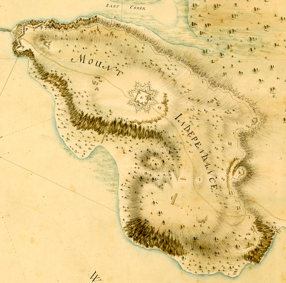
Realizing that the dilapidated fort had been built by the French to defend against an attack from the south, the American commanders looked to develop the north-facing promontory across the quarter-mile-wide southern extension of Lake Champlain. Called East Point or Rattlesnake Hill, the Americans renamed it Mount Independence after news of the Declaration of Independence arrived. The Mount became home for thousands of American soldiers until July 1777, when British Gen. John Burgoyne’s advance forced an evacuation. The British 62nd Regiment initially garrisoned the fort but was soon replaced by the 53rd, which along with the German Prinz Friedrich Regiment lived and worked there until they abandoned the post four months later. The Mount did not experience any long-term occupation or development for the rest of the war.
The site offered major advantages to anyone defending it. The lake safeguarded the west and north sides and a wide, muddy creek with drowned lands on both sides limited the eastern approach. Land access could be achieved only by crossing a mile-wide forested plain on the south end. More importantly, the Mount consisted of a block of bedrock with a relatively flat top of around 350 acres surrounded by cliffs and steep, rocky inclines up to 200 feet high. Even the few gentler inclines had challenges for an attacker. Over thousands of years, chunks of rock had broken off the edges of the upper layers of rock leaving the slopes below covered with rubble of all sizes.[2] Trying to advance up an incline like that while under fire would be costly.
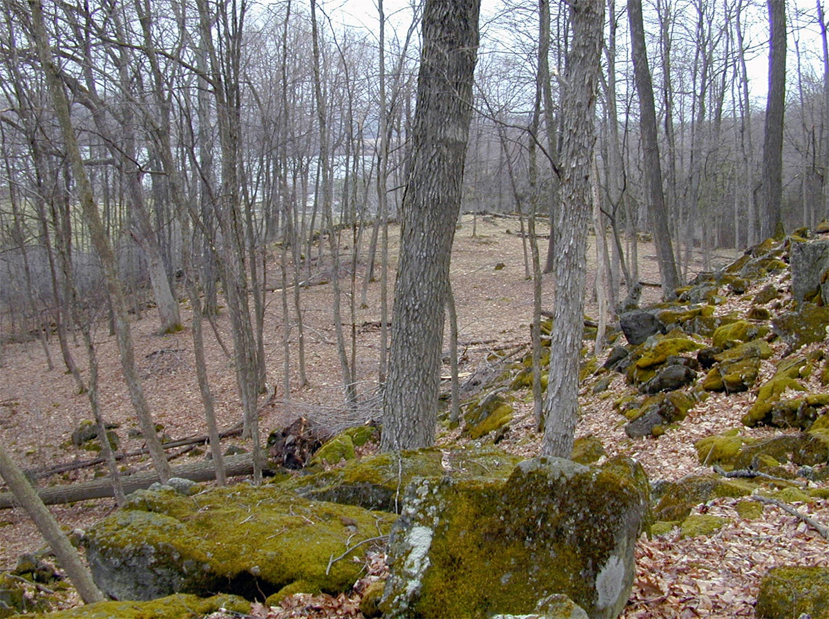
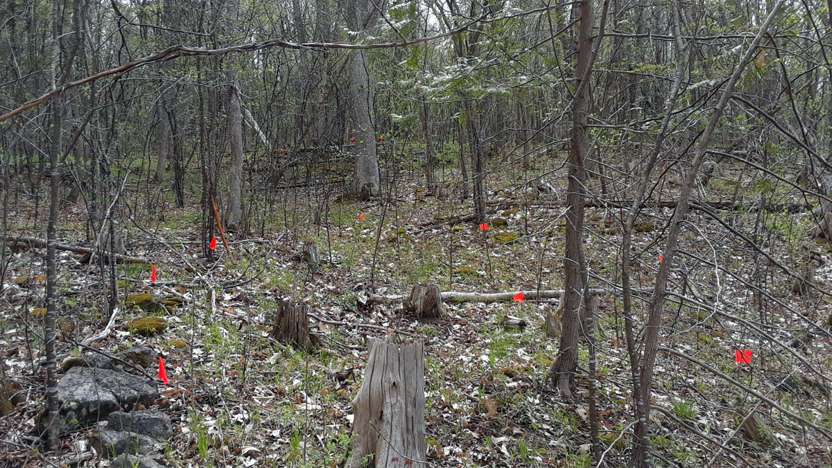
Mount Independence presented challenges to defenders as well. A handful of ravines cut by nature into the faces of the heights provided difficult but passable routes by which an attacking force could reach the top. Both armies expended considerable effort in building defenses for these passages. Little primary source information concerning these works has been found: a very limited number of defensive structures appear on period maps and hardly anybody wrote about them. The remnants of some of these works can still be seen and they give us clues as to what the builders had in mind to protect themselves.

The three LIDAR maps showing the following defensive positions are produced using the slope angle—the darker the color, the steeper the incline. These are details from a base map produced by Vermont Center for Geographic Information, with details inserted by the author.
Southern Battery
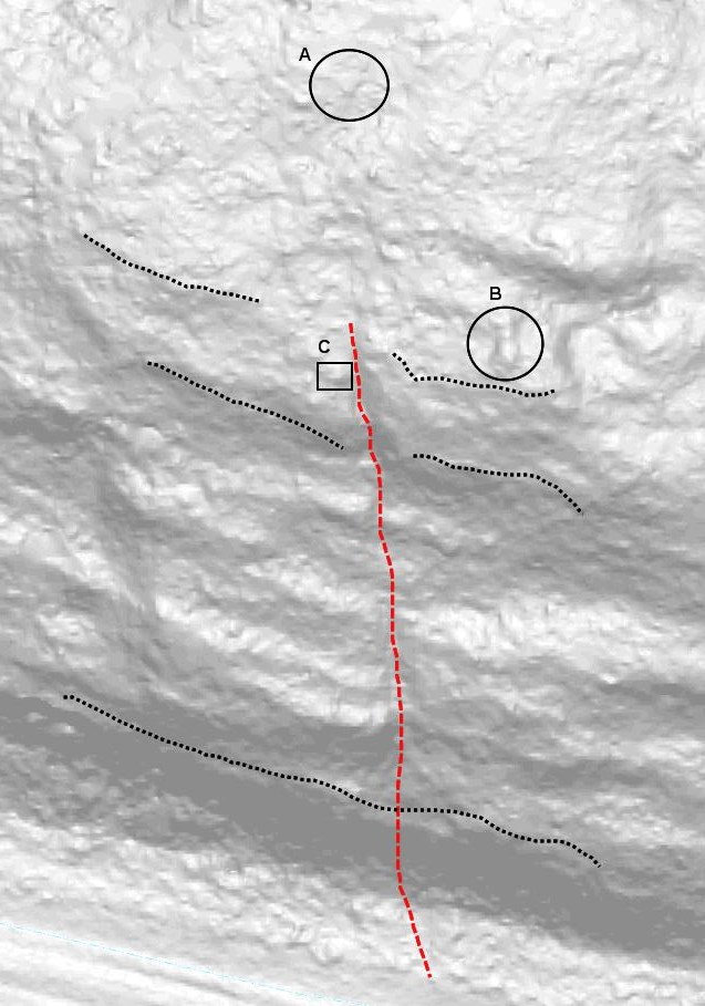
The southern heights of the Mount rise at a steep angle from the north end of the plain. In the middle of those heights, a large inverted-V ravine has its point at the edge of the natural barrier’s top. Two level areas—one half-way and the other about three-quarters of the way up—fill the middle of the V. The open end of the V allows at least two avenues for attackers to follow (Figure 2). On the left side of the ravine, one avenue leads straight up the heights over the rock rubble with the level areas on its right (A). The other route is a wide path leading diagonally to the right up the heights passing in front of the level areas (B). When it reaches the right wall of the ravine, the path turns sharply left and goes around to the back of the upper level area (because this path is relatively smooth, it may have been used as an access road).
With the exception of the northern point of the Mount, this ravine drew the most attention by the defenders. Begun by Jeduthan Baldwin and expanded by Thaddeus Kosciuszko, the fortifications consisted of three tiers. At the base of the Mount, soldiers laid down fraises, a thick tangle of felled trees and brush with sharpened branches pointing out. Attackers would have to thrash their way through this deep and dense obstruction as the branches caught on their clothing, equipment, and skin—all the while, defenders could lay down a continuous fire on them. This is precisely what Gen. James Abercromby’s men experienced in their attack on Ticonderoga’s French Lines in 1759.
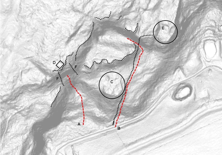
Built on the lower of the level areas, an artillery battery served as the heart of this set of works (C).[3] The middle of three such batteries built on the half-mile-wide southern heights (Fig. 1, “h”) and elevated ninety feet above the plain, the cannons could fire on any attackers long before they reached the base of the Mount. Stone and log walls on both levels and along the crest shielded infantry (dotted lines).

The third tier sat on the crest of the high ground. More fraises and stone and log walls ran along the full length of the crest (Fig. 1, “i”).[4]To reach this line from the second level, attackers had to climb an even steeper, rock-covered incline for some eighty feet. At the head of this approach a blockhouse built to accommodate several dozen men and two cannons had been constructed (D). A few yards to either side of the blockhouse sat log houses adding more fire support for the walls’defenders (Fig. 1, “k”).[5]
Movement up either access route could not have been easy. Attackers climbing straight up the ravine had to scramble some 200 feet over rocks and boulders just to reach the battery at the first level all the while enduring cannon and small arms fire from their front and flanks. Those following the path had a stone wall on their left along the full length of the trail that restricted any effort to turn straight up the incline. As they climbed, the attackers had to endure constant fire into their left flank for 250 feet just to reach the lower level. At that point, they would begin to receive fire in their front from another battery (E) and additional infantry positions behind walls on the second level and the crest of the heights. From there, they had to move another 150 feet and turn a sharp left to continue the climb to the second level where they found the continuation of the pathway’s stone wall blocking the route. Should these parties gain the level areas, they still had farther to go to gain the top.
To add to an attacker’s challenges as they ascended from the second level to the top via the left approach, stone walls (possibly surmounted with wooden works that have long since rotted away) had been constructed running up the incline that confined the attackers to a channel with the blockhouse at its summit (F). More rocks and boulders had been thrown into this channel making an already difficult climb considerably more challenging. It seems that the defenders took every possible measure to impede any attacking force.[6]
Waterfront Ravine
The positions discussed above appear on most period maps. The occupiers of the Mount built many more works than appear on any plans. An example is a collection of fortifications that included a road, artillery positions, walls, and support buildings situated at the head of another ravine.

The feature these constructs guarded does not have much in common with the one discussed above. An attacker approached the first via a broad plain with trees that would shield them from enemy view and fire until they reached the area near the base of the Mount that had been cleared. Anyone wishing to attack the second ravine had to approach it via the lake: men would be exposed to enemy view and fire for a much longer time. And, of course, they would be in boats with no shelter. On either side of the foot of the ravine, nearly vertical 200 foot cliffs limited landing choices. To further complicate an attack, the ravine had minimal area at its base on which to form, rising directly out of the water. Men had to begin their ascent immediately in order to make room for the next landing party (Figure 3).
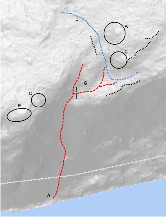
Other characteristics of the ravine created more problems. Rather than having a broad opening at the base with two avenues by which to advance, this ravine offered only one much narrower route (A) and, even though it ran at an angle up the incline, the climb would be rockier and steeper than that of the first ravine (about forty-five degrees for much of the way). Its only positive characteristic came from the fact that it quickly leveled out and opened up once near the top—but only after a climb of about 250 feet.
The defenders had their own problems. The entrance would certainly have been blocked by fraises and other obstructions but, because of the difficulty of retreating from there to the top, it is unlikely there would have been many, if any, men defending this area. Nor did this ravine have any large level area part way up for an intermediate defensive position. Here, defenders had to rely on the difficulty of the climb to tire the attackers and on fields of fire from the positions on top to stop an advance. A breakthrough at this point would give the enemy access to the entire Mount.
The center of the defense consisted of an artillery battery installed on a platform about fifty yards from the top of the ravine and firing directly into it (B). To the left and forward of this battery sat a smaller position that also fired directly into the ravine (C). On the high side of the ravine sat another platform (D) but it is questionable whether cannon here could be depressed enough to fire down into the ravine. The platform, rather than being flat, was angled downwards towards the front by a few degrees more than normal which would easily allow a cannon to fire into the flanks and rear of any enemy that reached the crest of the ravine.[7]
Defenders built works other than those for artillery to fire on the ravine. A bit farther along to top of the cliff to the right sat another position likely built for artillery (E). Most of the ravine cannot be seen from this point so any armament here had another target. It is safe to assume the target was enemy watercraft out on the lake. Given that the position sat 200 feet higher than the lake, the range of any weapons mounted here would have been increased considerably. Stone walls (dotted lines) served as infantry positions and there certainly were wooden works such as walls, fraises, gabions, and abbatis but these, of course, have long since rotted away.
The remnants of other features are scattered around the area of the ravine’s top. Indications of buildings used to support the defensive positions—possible magazine, barracks, blockhouse, etc.—have been located. A road passed along the top of the cliff and through the middle of the defenses (F). The banks to the front of the two batteries at the head of the ravine (B and C) have each been built up with rocks and may have served as ramps to move between the road and the platforms. An extension off a bend in the road overlooks much of the ravine and would have been a perfect position for infantry (G), but no indications of fortifications have been found (they may have been wooden). Clearly, defenders felt this area needed more than casual attentio
Small Ravine
Smaller ravines and those less exposed to direct attack still provided a source of concern. They did not have as much effort put into them as the above examples. One such ravine had the ubiquitous fraises backed by walls manned by infantry at its foot (Figure 3, dotted lines). Remnants of other stone walls can still be seen and it is likely wooden walls provided additional cover for infantry. Directly in front of the head of this ravine, defenders built an artillery platform (A) with another farther forward and to one side (B). The field of fire for both of these extended beyond the base of the Mount into the approach area. At the immediate top of the ravine is a small, three-sided stone structure that may have been used as an observation post (C).[8]Some period maps show a blockhouse sitting on the high ground in this area but its exact location has not been identified. As with other defensive positions, indications of structures built to support the works can be seen.
Conclusion
Both armies spent considerable energy in building defensive positions all across Mount Independence; this discussion has looked at just three. There are scores of other defensive works along with many more locations of magazines, hospitals, living quarters, latrines, and so on. Walking along the more than six miles of trails developed by the Division for Historic Preservation, visitors can get just a glimpse of the things the armies built nearly two-and-a-half centuries ago. If one pauses, closes their eyes, and lets their imagination take over for a moment, they can almost hear the thunk of axes, singing of saws, ringing of hammers, and the chatter, cursing, and laughter of the men who did the work.
[1]Lake Champlain flows north so going “up” the lake is heading south.
[2]For details on the site’s geology, see Helen Mango, “Geology of the Mount Independence State Historic Site,” ottohmuller.com/nysga2ge/Files/2002/NYSGA%202002%20C5-%20Geology%20of%20the%20Mt.%20Independence%20State%20Historic%20Site,%20Orwell%20Vt..pdf.
[3]The defenders built the two artillery batteries guarding this ravine “en barbette,” meaning that the walls did not have embrasures through which the cannons fired. Instead, the entire wall had a flat top allowing any number of guns to be placed anywhere along the wall. In both batteries, there is a ditch between the wall and the platform on which the guns sat. Why? This author has been unable to document a reason for the ditch but suspects the crews serviced the guns while standing in the ditch. With the wall being low, standing in the ditch afforded the men more protection. Similar construction can be seen in the Horseshoe Battery at the north end of the site.
[4]Ensign Julius Friedrich von Hille, The American Revolution, Garrison Life in French Canada and New York: Journal of an Officer in the Prinz Friedrich Regiment, 1776-1783, ed. and trans. Helga Doblin and Mary C. Linn (Westport, CT: Greenwood Press, 1993), 79.
[5]The exact locations of these houses have not been verified.
[6]The Mount Independence State Historic Site has installed handicap-accessible trails and a bridge across the ravine so that visitors can view the features described above. Vegetation around the battery and the blockhouse foundation has been cleared (thanks in large part to the ongoing efforts of staff member John Melanson) providing a view much like that seen by the Mount’s defenders.
[7]The front of artillery platforms usually sat a bit lower to help limit recoil and the effort needed to run the gun back forward. Captain George Smith, An Universal Military Dictionary (London, J. Millan: 1779), 22.
[8]Several of these features have been found along the crest of the Mount’s sides.


2 Comments
Mike – Very interesting article and use of LIDAR technology. You should give a seminar on 18th-century fortifications and military engineering! From your description, it’s easy to see why John Brown failed to re-capture Mt. Independence in 1777.
Do you believe that the British cannon on Mt. Defiance doomed the works at Mt. Independence? I believe it is a longer shot than Ft. TI but within cannon range. I have always wondered if the Americans should have used a different strategy to protect the Champlain/Hudson Valley corridor such as fortify Crown Point, focus on Mt. I, or defend further down the lake (especially after losing most of the warships in 1776).
Thanks for the positive comments, Gene. They are greatly appreciated.
Brown’s raid on Mt. I. and Ti is another of those actions generally lost to history. I’m doing a presentation on it in August–maybe I’ll form it into an article and submit it for JAR consideration.
Cannon on Mt. Defiance could reach nearly all of the works at Ti or on the Mount but that’s not really the problem for the Americans. Rather, it’s the fact that the Crown forces could sit up there and count every American soldier and report their movements to Burgoyne. I did an article for the Mount Independence Coalition on cannon ranges, distances from Defiance to various parts of the American works, Trumbull’s tests, etc.–maybe I should do the same with it as above.
The Americans abandoned Crown Point in 1776 for a couple of reasons. For one, it needed far more work than Ti (it had burned and partially blown up in 1773). For another, it did not have anything like Mt. Independence to protect the east side of the lake. The American defensive plans would have worked had the numbers present in the fall of 1776 (over 12,000 men) returned in ’77. The American powers-that-be did not believe the enemy would make a major move up the lake and, as a result, they chose to support Washington around New York instead of the Northern Dept. army.