


Continental Army general George Washington sat atop his horse ignoring the “smart skirmish” raging around him.[1] He could have joined his soldiers in attacking the Hessian troops “very much allarm’d” by the Americans’ “sudent appeerence before their works.” [2] Instead, Washington focused on the fortifications just beyond the Germans. The skirmish that occurred on July 3, 1781 was a rare opportunity to personally observe the Crown fortifications on northern Manhattan.[3] Washington took tremendous risk during this engagement. So much so that the Hessians wounded sixteen of the Commander in Chief’s Guard during the skirmish; one of the Americans even took a bayonet to the leg, but Washington wanted a good look at the enemy earthworks.[4]
If Washington was going to retake New York – his primary goal for the 1781 campaign season – he would need as much information as possible about the Crown’s defenses of the island. The July 3 action “afforded Genl DuPortail and myself the most favorable opportunity of perfectly reconnoitreing the works upon the north end of the Island and making observations which may be of very great advantage in future.”[5] However, after further consultation with his French allies led by Jean-Baptiste Donatien de Vimeur, comte de Rochambeau, Washington decided a more formal reconnaissance needed to take place.[6] This time, French military engineers would accompany Washington. Washington was a trained surveyor, but these officers had spent their entire careers preparing for just such an operation. While their soldiers demonstrated in front of the Crown defenses, Washington, Rochambeau, and their engineers would carefully record every redoubt, frise, and abatis they could find. The reconnaissance in force was the first joint action Washington and Rochambeau took part in together and the first real test of how good of a team the men would make.
Washington issued the initial orders for the reconnaissance on July 13, but “incessant rain” prevented the allies from leaving their camps near Dobbs Ferry.[7] Undeterred, Washington and Rochambeau decided to make the most of the delay. On July 18, the two commanders – along with 150 soldiers for protection – crossed into New Jersey to look down on the British position from the heights of the Palisades. Northern Manhattan “was totally stripped of Trees, & wood of every kind; but low bushes (apparently as high as a Mans waste) appear in places which were covered with Wood in the year 1776.” The larger Crown positions were all “well friezed, ditched & abattied—In a word to be strong and in good repair.” [8] Roughly six battalions’ worth of British and German soldiers garrisoned northern Manhattan’s defenses.
At 8 o’clock on the evening of July 21, “Retreat” sounded in the allied camp just as it had many other nights, but on this occasion, rather than signaling thousands of French and American soldiers to begin preparing to sleep, it ordered them to march. Roughly 4,000 men started south towards Manhattan encumbered by the “pitch dark night.”[9] “This march over execrable roads,” recalled Alexandre Berthier, the future chief of staff to Napoleon Bonaparte, meant his column “halted every few minutes.”[10]

The French and American forces divided into four major columns which allowed them to move towards the Crown positions as rapidly as possible.[11] Continental Army Col. Alexander Scammel commanded the detachment descending the road paralleling the Hudson River, consisting of his light infantry regiment and the troopers of Col. Elisha Sheldon’s legion. To their left, Maj. Gen. Benjamin Lincoln commanded the main Continental Army contingent of roughly 1,500 soldiers who took the Saw Mill River Road. Along the Sprain Road, under the supervision of Maj. Gen. François Jean de Beauvoir, chevalier de Chastellux, marched the Regiments Bourbonnais and Royal Deux-Ponts along with half of the French expedition’s grenadier and chasseur companies.[12] Finally, to the furthest east, the remainder of the French grenadiers and chasseurs, accompanied Armand Louis de Gontaut, duc de Lauzun and his legion which screened the movements of the main body to their west. Additional American forces patrolled the roads of Eastchester, monitored British activity on the Hudson River, and observed the enemy camps from the heights of the New Jersey palisades.[13] Their mission was to seal off the Crown forces on northern Manhattan from any support local Tories or the Royal Navy might try and provide.
“A number of mountains, narrow passes, woods, and bad roads made” the allied march an ordeal and “the artillery had the greatest difficulty in advancing.”[14] In the main French column, “a caisson fell down a precipice 40 feet deep,” and forced the artillerymen to light fires to see well enough remove their trapped comrades, horses, and equipment.[15] The Bourbonnais’s colonel, Anne-Alexandre-Marie-Sulpice de Montmorency, marquis de Laval, grew so tired of waiting on the artillery, he ordered the infantry to press on.[16] By one o’clock in the morning on the 22nd, the French infantry rendezvoused with the Americans at Valentine’s Hill only a few miles from the British positions near King’s Bridge. Rochambeau was “obviously annoyed” that the artillery had been left behind. He ordered Berthier to go back and “not to return until I had found [the artillery] and urged it forward with all speed to join the troops.”[17]
While Berthier returned to the rear, Lincoln and Chastellux began moving the two main allied bodies into their final positions. Now, for the first time, many of the allied soldiers had the chance to observe one another in action. The French were “astonished at the manner in which [the Americans] marched; a perfect silence and order reigned; to which they added the greatest possible celerity.”[18] “I admire the American troops tremendously,” wrote the Baron Ludwig von Closen, “it is incredible that soldiers composed of men of every age, even children of fifteen, of whites and blacks, almost naked, unpaid, rather poorly fed, can march so well and withstand fire so steadfastly.”[19]
That resoluteness under fire would prove useful shortly as they came within site of the enemy pickets. Col. Jean-Francois-Louis, comte de Clermont-Crevecoeur noted that “The English seemed amazed, not having the slightest suspicion of our march.”[20] Washington proudly boasted in his personal diary that, “The enemy did not appear to have had the least intelligence of our movement or to know we were upon the height opposite to them till the whole Army were ready to display.”[21]

The Franco-American forces extended out over a front nearly two and a half miles long. Scammel and Sheldon’s troops focused their attention on the Spuyten Duyvil creek and its junction with the Hudson river. Their responsibility was to look for possible crossing sites to Manhattan and watch for any Crown movement against Washington’s right flank.[22] The main line of battle, consisting of Lincoln and Chastellux’s commands, stretched from the site of the now defunct Fort Independence – only three quarters of a mile from King’s Bridge – southeast to the De Lancy Mill.[23] They halted roughly a mile and a half from the British-occupied Redoubt Number 8 and prepared to advance further or hold their ground against a Crown attack. Lauzun’s legion rode as fast as possible towards Morrisania to try and capture Tory partisans under the command of Oliver De Lancy. Lauzun was supported by the chasseur and grenadier companies that had accompanied his force from the French camp.

While the infantry and cavalry moved into position, Berthier was still franticly searching for the wayward allied artillery. 2,500 miles from home, the young French officer found himself “alone without knowing where I was going in a perfectly strange country full of enemy bands”[24] The darkness of course made his job even more difficult. To find out which path the artillery had taken, Berthier had to repeatedly “dismount and feel the road at every crossroads to see if there were any tracks imprinted by the wheels in the dirt.” After considerable searching, he “felt ruts where [the artillery] had taken the wrong turn.” Berthier rode as fast as he could, found the French cannon, and got them back on the route to Rochambeau and Washington. By five o’clock in the morning, just at daybreak, the artillery rejoined the allied force.
The sudden allied movement from their camp may have surprised the Crown soldiers near Manhattan, but they reacted quickly enough to avoid disaster. The Hessian jaegers on picket duty immediately began firing on the Franco-American skirmishers to their front. This fighting retreat towards King’s Bridge provided the time needed to evacuate cattle and horses grazing on the mainland back onto Manhattan. Within fifteen minutes of the first shots, British light dragoons were ferried across the Harlem River to further oppose the French and American forces. The troopers rode to the assistance Redoubt Number 8, an open-backed fortification the British feared the allies might try and take by a quick coup de main. American dragoons quickly scattered the British horsemen, but made no attempt to move on the redoubt.[25]
With the field clear of British cavalry, Washington ordered an attack on Redoubt Number 8. Two battalions – one French and one American – along with some accompanying artillery prepared to advance. The Americans took up a position behind the fallen-in walls of Fort Independence and deployed skirmishers forward. The French combined battalion of chasseurs and grenadiers – commanded by Rochambeau’s son – formed on the American left as a support. When all the arrangements were complete, the Americans “marched under the fire of No. 8 very valiantly and in very good order.”[26] Pummeled by the artillery emplaced in both the redoubt to their front and the larger British forts on the mainland, “the troops reached the position under fire from the enemy guns, which took off the leg of one of their officers.”[27] The attack faltered, and Washington ordered the battalion to pull back and simply try to keep the attention of the redoubt’s occupants as best they could.

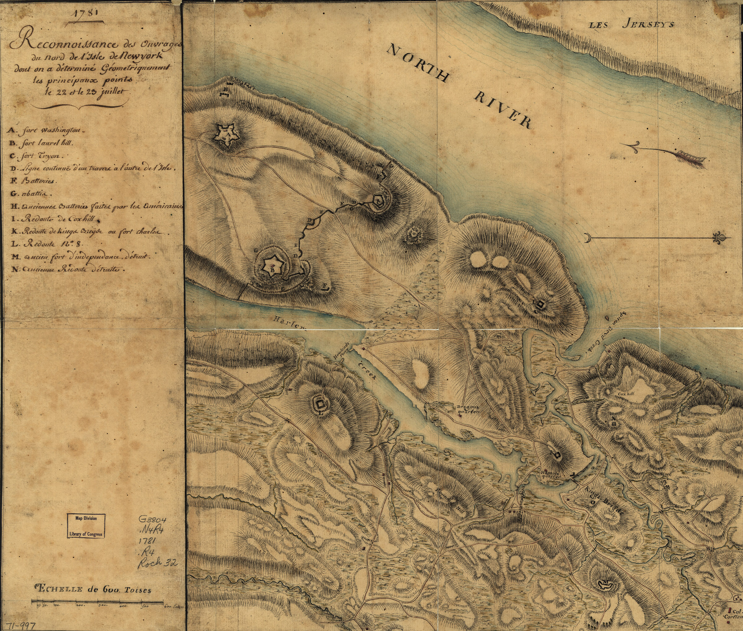
Washington then began “with General Rochambeau and the Engineers, to reconnoitre the enemy’s position and Works first from Tippets hill.”[28] The two senior generals noted numerous deficiencies in the Crown works along Spuyten Duyvil creek, but the larger forts farther down the island seemed to make up for their smaller cousins. Washington and Rochambeau needed a better look at those fortifications. They – and roughly forty accompanying staff officers – rode down from Tippet’s Hill and joined the advanced American battalion to the front of Redoubt Number 8.[29] “From this view, and every other” Washington “could get of Forts Tryon, Knyphausen & Laurel hill,” it was clear the British engineers had done valiant work since originally taking those positions in 1776.[30] Clearly any direct attack on the forts across the Harlem River would be costly, but perhaps a crossing to the island existed further south.
Washington and Rochambeau left Lincoln and Chastellux in command of the army and lead their staff towards Morrisania. Wanting to move as fast as possible, they even left behind the infantry portion of Washington’s Commander in Chief’s Guard. A handful of dragoons and the generals’ aides provided their only protection from capture.[31]
Near Montresor’s Island (modern day Randalls and Wards Island), the dragoons and aides spotted a party of roughly twenty Tories. They immediately informed Washington and Rochambeau of the danger. Undeterred, the generals gave their aides permission to charge the enemy troops. Drawing their sabers and saluting each other in grand style, the French and American horsemen galloped over the hill and surprised the Tories, who retreated towards a nearby home. The two sides exchanged fire for some time, “a great number of balls whistling around.” [32] A British battery on the far side of the Harlem surprised the allies. One of Rochambeau’s aides, Joseph-François-Louis-Charles-César, duc de Damas, lost his horse to the British artillery, but was not wounded himself. A Tory, believing they had killed Damas, ran from a house screaming “Die, you dog of a Frenchman” as drew he a pistol and charged Berthier. “I got ahead of him by putting a ball through his chest,” Berthier later recalled.[33]
Despite the seriousness of the situation, the allied officers found levity after the fact at the expense of von Closen, who almost lost his hat in the engagement. While charging the Tories, a tree branch snagged the young French nobleman’s headgear. Naively, he dismounted his horse to retrieve the wayward piece of uniform. Washington later ribbed Closen for his foolishness, and the baron’s son eventually commissioned a painting of the incident for posterity. Everyone could joke about the affair because the Tories had not managed to wound a single American or Frenchman.[34]
The rest of the day’s reconnaissance proceeded without interruption. By 9 o’clock that night, after almost twenty-four hours in the saddle, Washington, Rochambeau, and their staff finally sat down for a hearty supper of chicken fricassee. However, they were back to work seven hours later preparing to scout landing sites on Long Island at 4 o’clock on the morning of July 23.[35]
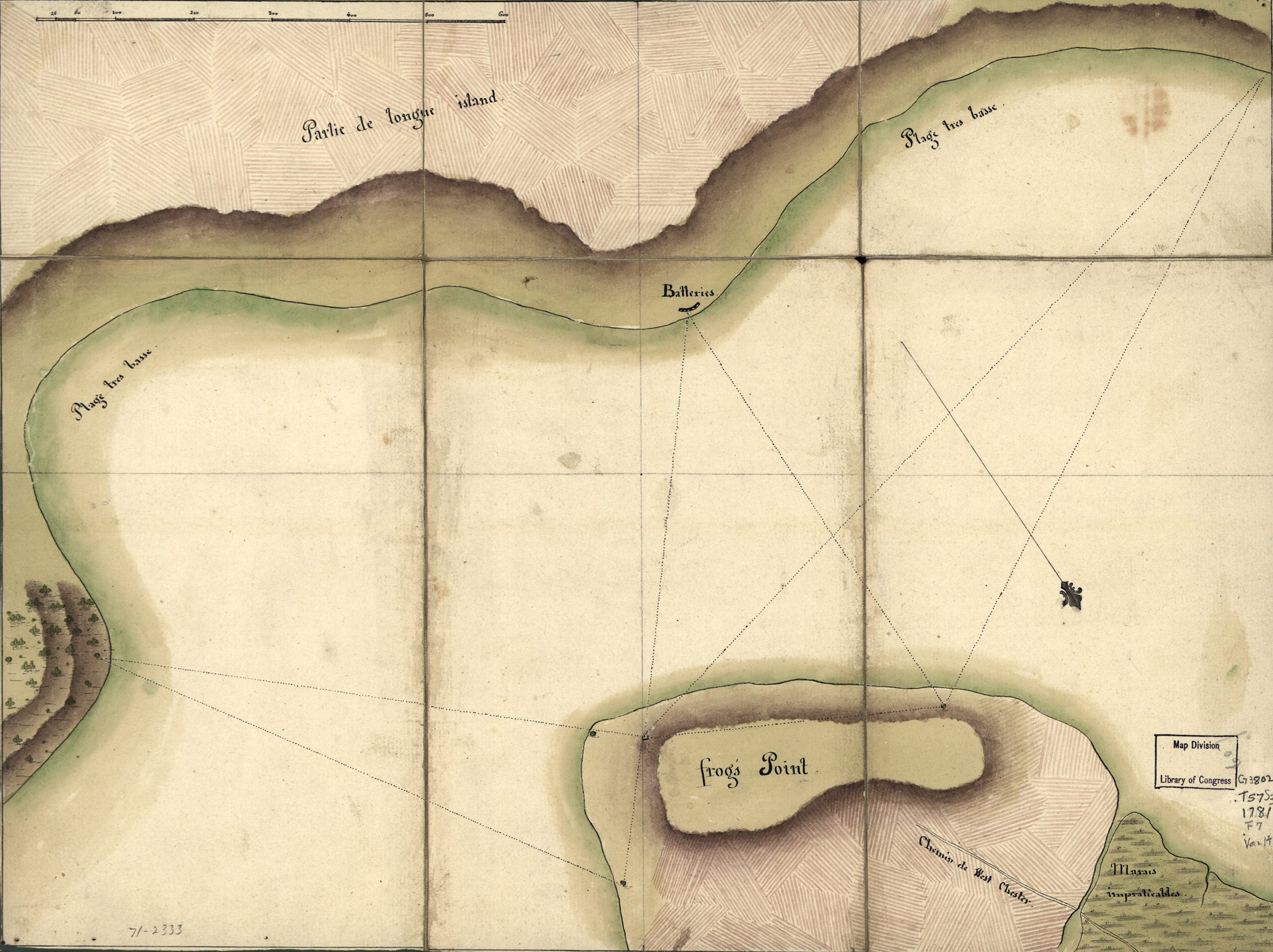
The generals and their staff officers rode to Throggs Neck, a peninsula jutting out into the Long Island Sound that would allow the French engineers a prime location for conducting their surveys. The reconnaissance took most of the day, and Washington and Rochambeau used the downtime to discuss the feasibility of attacking New York as well as to get to know each other a little better. Unlike their previous highly scripted conferences, here the two men could just sit together on a beach abutting the Long Island Sound while their engineers busily measured the far shore and Continental Army dragoons provided security. It seems their respective staffs kept their distance as well. So much so, that a small crisis occurred.
The two generals had gotten so comfortable on the peninsula that they fell asleep and did not notice the tide had come in and made Throggs Neck an island! Further, some British ships on the sound took advantage of the tide to get closer to the surveying party. Rochambeau was the first one to be awakened by the enemy cannonading.[36] He quickly roused Washington, and the two men ran to the far end of the island carrying their saddles. Their aides scrambled to place the generals into boats then made their own way off the island by laying planks down over some marshy terrain. The dragoons providing security unsaddled their horses and swam them across the rising waters of the inlet. Once back on the mainland, everyone proceeded north to rejoin the main force near King’s Bridge.[37]
With the reconnaissance now complete, Washington and Rochambeau issued orders for their troops to fall back to the French and American camps near Dobbs Ferry.[38] Along the way and in the days after, Washington and Rochambeau scoured over the notes they had taken and the maps the French engineers prepared. The results were conclusive: the British used their five years in Manhattan to tremendous effect.
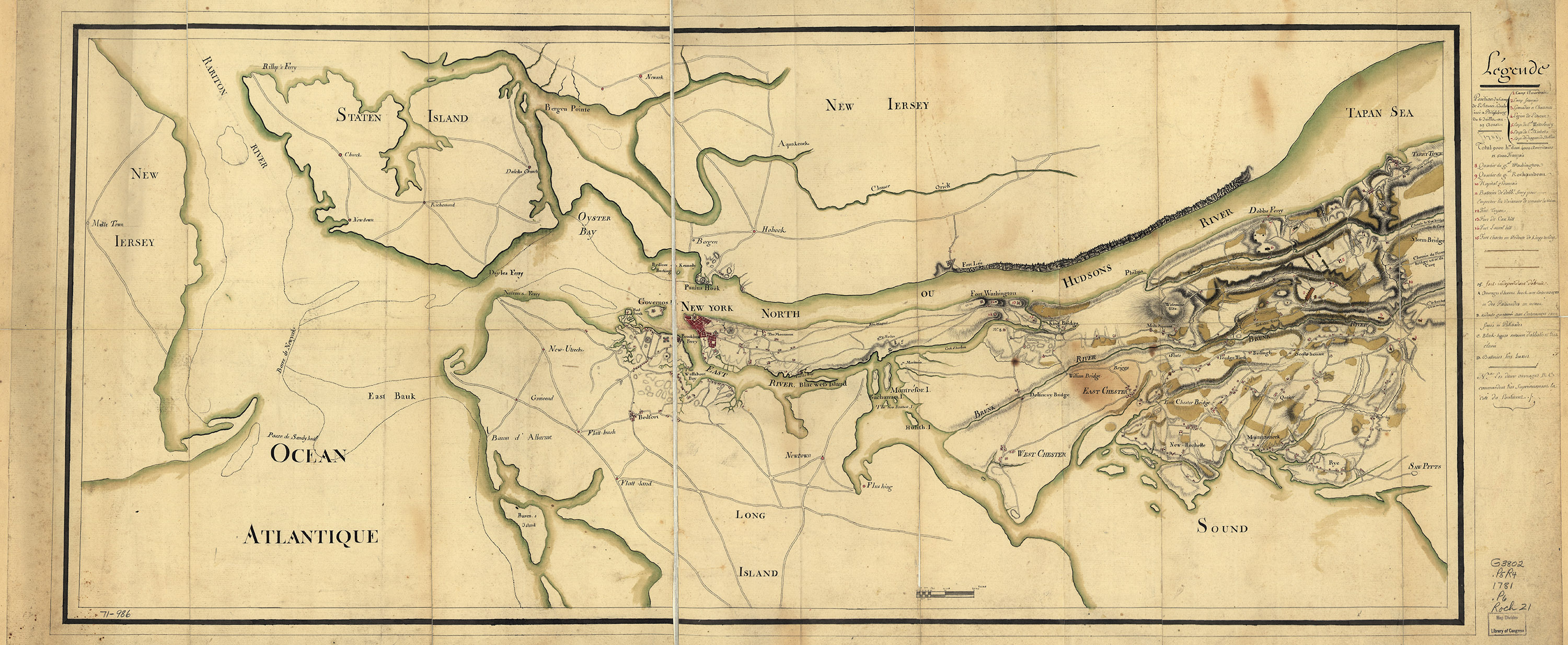
The French maps, many of which are now in the possession of the Library of Congress in Washington, D.C., show that attacking northern Manhattan would have been a nightmare for the Americans and their French allies.[39] However, without naval support, the northern end of the island was the only viable crossing point onto Manhattan. Any attempt made further south risked the direct opposition of the Royal Navy and encirclement by Crown ground forces landed in the rear of any advancing allied army. The August 14 news that Lieutenant Général des Armées Navales François-Joseph Paul, comte de Grasse’s fleet would arrive at the Chesapeake caused the final orders to move against Maj. Gen. Charles Cornwallis’ forces at Yorktown, Virginia.[40] However, the July 22-23 reconnaissance of northern Manhattan, and the realization of just how strong the Crown positions were, inspired Washington and Rochambeau to formalize their contingency plans and have their staff start to prepare for a movement to the south as early as August 1.[41] Overall the reconnaissance was an impressive piece of operational skill by two armies, and two commanders, that had never worked closely together. The success of the New York reconnaissance boded well for future Franco-American operations, and a welcome departure from the earlier fiascos at Savannah and Newport.
[1] Joseph Plumb Martin, Private Yankee Doodle: Being a Narrative of Some of the Adventures, Dangers and Sufferings of a Revolutionary Soldier, ed. George E. Scheer (Boston: Little Brown and Co., 1962), 213.
[2] Henry Dearborn, Revolutionary War Journals of Henry Dearborn, 1775-1783, eds. Lloyd A. Brown and Howard H. Peckham (Chicago: The Caxton Club: 1939), 212.
[3] George Washington, diary entry, July 3, 1781, Founders Online, National Archives, http://founders.archives.gov/documents/Washington/01-03-02-0007-0003-0002.
[4] Bob Ruppert, “His Excellency’s Guards,” The Journal of the American Revolution, https://allthingsliberty.com/2014/08/his-excellencys-guards/ (accessed May 18, 2017).
[5] Washington to Samuel Huntington, July 6, 1781, Founders Online, National Archives, http://founders.archives.gov/documents/Washington/99-01-02-06303.
[6] Washington to Jean-Baptiste Donatien de Vimeur, comte de Rochambeau, July 12, 1781,” Founders Online, National Archives, http://founders.archives.gov/documents/Washington/99-01-02-06380.
[7] Washington, diary entry, July 14, 1781, Founders Online, National Archives, http://founders.archives.gov/documents/Washington/01-03-02-0007-0003-0010; Washington’s Instructions, July 13, 1781, Founders Online, National Archives, http://founders.archives.gov/documents/Washington/99-01-02-06394.
[8] Washington, diary entry, July 18, 1781, Founders Online, National Archives, http://founders.archives.gov/documents/Washington/01-03-02-0007-0003-0014
[9] Ludwig von Closen, The Revolutionary Journal of Baron Ludwig von Closen, 1780-1783, trans. ed. by Evelyn M. Acomb (Chapel Hill: University of North Carolina Press, 1958), 97.
[10] Alexandre Berthier, in The American Campaigns of Rochambeau’s Army, 1780, 1781, 1782, 1783, trans. and ed. Howard C. Rice Jr. and Anne S. K. Brown, Vol. 1 (Princeton: Princeton University Press, 1996), 251.
[11] Washington’s Instructions, July 13, 1781, Founders Online, National Archives, last modified March 30, 2017, http://founders.archives.gov/documents/Washington/99-01-02-06394.
[12] Berthier, in The American Campaigns, 251.
[13] Washington to Elias Dayton, July 21, 1781, Founders Online, National Archives, http://founders.archives.gov/documents/Washington/99-01-02-06468; Washington to John Pray, July 21, 1781, Founders Online, National Archives, http://founders.archives.gov/documents/Washington/99-01-02-06474; Washington to David Waterbury, July 21, 1781, Founders Online, National Archives, http://founders.archives.gov/documents/Washington/99-01-02-06479.
[14] von Closen, Revolutionary Journal, 97.
[15] Jean-Francois-Louis, comte de Clermont-Crevecoeur, in The American Campaigns of Rochambeau’s Army, 1780, 1781, 1782, 1783. Trans. and ed. Howard C. Rice Jr. and Anne S. K. Brown, Vol. 1 (Princeton: Princeton University Press, 1996), 36.
[16] Berthier, in The American Campaigns, 251.
[17] Ibid., 252.
[18] Marie François Joseph Maxime Cromot du Bourg, “The Diary of a French Officer 1781”, The Magazine of American History with Notes and Queries, Volume IV (New York: A. S. Barnes & Company 1880),302.
[19] von Closen, Revolutionary Journal, 102.
[20] Clermont-Crevecoeur, in The American Campaigns, 36.
[21] Washington, diary entry, July 22, 1781, Founders Online, National Archives, http://founders.archives.gov/documents/Washington/01-03-02-0007-0003-0018.
[22] Washington to Alexander Scammell, July 14, 1781, Founders Online, National Archives, http://founders.archives.gov/documents/Washington/99-01-02-06407.
[23] My Campaigns in America: A Journal Kept by Count William de Deux-Ponts, 1780-1781, trans. ed. by Samuel Abbott Green (Boston: J.K. Wiggin and W.M. Parsons Lunt, 1868), 120; von Closen, Revolutionary Journal, 98-99.
[24] Berthier, in The American Campaigns, 252.
[25] von Closen, Revolutionary Journal, 98; du Bourg, “The Diary of a French Officer 1781”, 302.
[26] von Closen, Revolutionary Journal, 98.
[27] Clermont-Crevecoeur, in The American Campaigns, 37.
[28] Washington, diary entry, July 22, 1781, Founders Online, National Archives, http://founders.archives.gov/documents/Washington/01-03-02-0007-0003-0018.
[29] von Closen, Revolutionary Journal, 99.
[30] Washington, diary entry, July 22, 1781, Founders Online, National Archives, http://founders.archives.gov/documents/Washington/01-03-02-0007-0003-0018.
[31] Berthier, in The American Campaigns, 252.
[32] von Closen, Revolutionary Journal, 99-100.
[33] Berthier, in The American Campaigns, 252-253.
[34] von Closen, Revolutionary Journal, 100; Berthier, in The American Campaigns, 253, n.78; Howard C. Rice Jr. and Anne S. K. Brown, The American Campaigns of Rochambeau’s Army, 1780, 1781, 1782, 1783. Vol. 2 (Princeton: Princeton University Press, 1996), 139-141.
[35] von Closen, Revolutionary Journal, 100.
[36] Jean-Baptiste Donatien de Vimeur, comte de Rochambeau, Mémoires militaires, historiques et politiques de Rochambeau, ancien maréchal de France, et grand officier de la Légion d’honneur. Luce de Lancival Ed. (Paris: Chez Fain, 1809), 284-284.
[37] von Closen, Revolutionary Journal, 101.
[38] Clermont-Crevecoeur, in The American Campaigns, 38.
[39] Reconnoissance, Juillet 1781. [1781] Map. Retrieved from the Library of Congress, https://www.loc.gov/item/gm71000994/; Reconnoissance des ouvrages du nord de l’Isle de Newyork dont on a déterminé géometriquement les principaux points le 22 et le 23 juillet. 1781. Map. Retrieved from the Library of Congress, https://www.loc.gov/item/gm71000997/; Reconnoissance de King’s bridge. I. [?, 1781] Map. Retrieved from the Library of Congress, https://www.loc.gov/item/gm71002332/; Position du camp de l’armée combinée a Philipsburg du 6 juillet au 19 aoust. [1781] Map. Retrieved from the Library of Congress, https://www.loc.gov/item/gm71000986/
[40] Paul-François-Jean-Nicolas, comte de Barras to Washington, August 14, 1781, Founders Online, National Archives, http://founders.archives.gov/documents/Washington/99-01-02-06680; Washington, diary entry, August 14, 1781, Founders Online, National Archives, http://founders.archives.gov/documents/Washington/01-03-02-0007-0004-0010.
[41] Washington, diary entry, August 1, 1781, Founders Online, National Archives, http://founders.archives.gov/documents/Washington/01-03-02-0007-0004-0001.


7 Comments
Great article on a little mentioned reconnaissance. I had certainly never heard about the close call at Throg’s Neck!
Thanks for your feedback Michael!
Yes, it comes off as quite the buddy adventure movie scene in most of the primary source retelling. What a near miss!
I’m looking for a good book on the early interactions, like the reconnaissance you’ve described here, of the French and American armies in New York and southern New England prior to their combined march to Virginia and Yorktown.
I don’t think you’ll find a book that goes into detail on this topic; it sure would be nice to have one. You’ll find a number of first-hand accounts in Howard C. Rice, Jr., and Anne S. K. Brown, The American Campaigns of Rochambeau’s Army 1780, 1781, 1782, 1783 (Princeton, N.J.: Princeton University Press, 1972), 2 volumes
Bob –
go here: https://w3r-us.org/
and then on History and History by State on the drop-down menu.
Bob
Thank you for this interesting and informative article. I hope somebody will devote a book, complete with detailed maps and orders of battle, to the campaign around New York City in 1781. It would a great addition to the literature of the American Revolutionary War.
Thank you for this comprehensive article!