


Almost anyone that develops a passion for history can point to an event deep within themselves that spawned an imaginative interpretation of events, and out of that, perhaps a lifelong passion for a certain historical period. The battlefield at Yorktown, Virginia covering the 1781 siege, certainly excites the imagination as one treks through the British defense lines and the various allied siege lines that drew ever closer to the capture and capitulation of the town and British garrison. Aside from the scars upon the land that provide the visual guide for our imaginations to drift to scenes of troops rushing up the slope and into a redoubt, there is another part of the visitor’s tour that is less visual, and because of that, seems to lack significance. The Encampment Tour is often overlooked and reserved as one of those places that only the well-studied visitor spends time partaking in. The parks audio CD (available at the Visitors Center) does not cover the events surrounding the allied encampments.
The Encampment Tour, an extension of a visitor’s battlefield tour, reflects various markers denoting where the armies of America and France spent the majority of their time during the siege. The tour itself leaves much to the imagination. The changed landscape from 1781 to the present further complicates the average visitor’s time spent viewing the wayside markers. The Encampment Tour brings a visitor to key positions at the opening of the siege (such as The Untouched Redoubt, Fusiliers Redoubt, and the Pigeon Hill Redoubt); it also takes you to ground occupied by many of the major stars on the allied side (such as the sites of American and French hospital locations, artillery parks, and the headquarters lots). The tour begins off to the side of the Surrender Field (Stop F), which is largely mistaken by many visitors as “the end” of the tour and the wayside markers along this route are quite far from each other, especially as you proceed to the French sites.
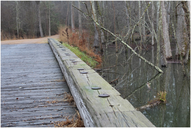
As you pass Stop F and proceed along the Encampment Tour road, it becomes time to excite your imagination. As you arrive at The American Artillery Park (Stop G) on your park map, you will eventually come upon a small bridge over the Beaver Dam Creek, also known as Great Run. There is a small sign nearby detailing the creek’s importance as a dividing line between the American and French forces about to encamp and organize the system that would soon feed the lines of the siege. The sign also serves as a reminder that George Washington maintained overall command and as a momentary pause to consider the language, military customs and cultural differences of the allied army. This spot is an excellent wayside to envision the incredible weight on Washington to deploy and utilize all the resources at his disposal, all while maintaining military order and direction over troops who were now taking orders from the former allies of the British.

Because the bridge is crudely constructed, it helps with imagining Washington’s men approaching, the British pickets in retreat, passing over and splashing through the swampy marsh at points. Peering around the marsh and trees, one can visualize a bridge set ablaze by the British to slow the allied column. We can only wonder what Washington’s advanced soldiers thought as they paused and set their eyes upon Banastre Tarleton’s green clad men on horseback sent out to reconnoiter the allied approach.[1]
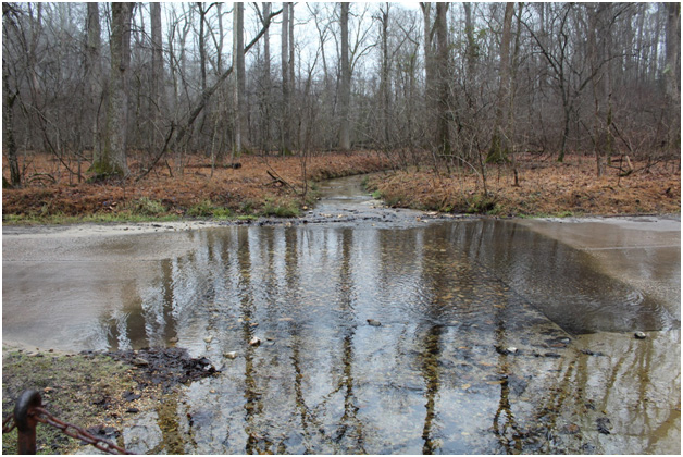
Passing a few more waysides, we move on to General Washington’s Headquarters (Stop H) but not before enjoying one of the National Park Service’s most brilliant designs. As you approach the tour stop, you will be given the chance to ford the small stream just as the troops in 1781 did regularly (except you enjoy the comfort of your own vehicle). This leads up the slope to the spot where Washington’s Headquarters tents (which are available for viewing at Visitors Center) would be established, a truly special place on the battlefield. Far from the excitement of the siege lines, this is the place where Washington and his many officers would formulate the strategy and planning that would lead to a ‘world turned upside down.’ Once you arrive, turn around to imagine Washington riding back and forth to the first and second siege lines for observation. Consider the busy environment as Washington personally reconnoitered the grounds and awaited the arrival of the main artillery. Visualize the dozens of couriers moving messages and orders back and forth. Stop H was the heartbeat of the 1781 siege and is quite a stop to any history buff looking to learn more about terrain and river fording.


Setting off from Washington’s Headquarters site, we proceed past the very solemn French Cemetery (Stop I). While there is some debate about whether the site is the actual burial ground, it is more important to pause here as a reminder of these brave soldiers who fought alongside the dwindling 1781 American army and employed their tactical, engineering, and military genius to help deliver American Independence.
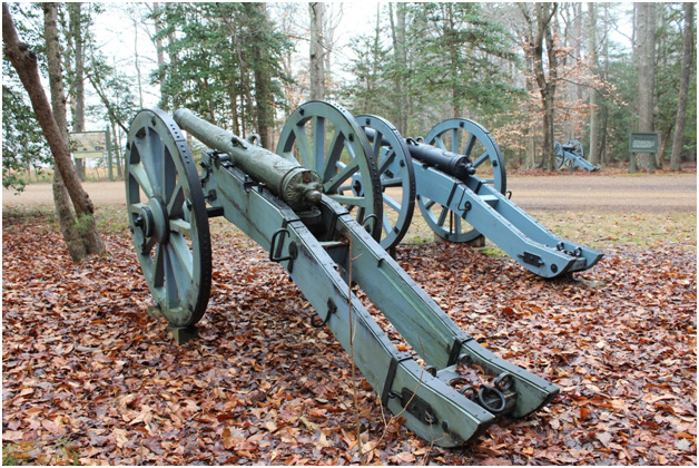
Finally, we make our way to The French Artillery Park (Stop J). The park service has done an excellent job at this stop; the grounds are beautiful with cannons and waysides. French artillery deployment was to play a pivotal role in making life miserable for those in the British inner defense lines, but here in a field that was 700 feet long and 300 feet on its sides, would be the storage and maintenance garrison for the pieces. The entire property containing the artillery park resided on land that was owned by Brig. Gen. Thomas Nelson, Jr., the commander of the Virginia Militia (about one third of the American troops at the battle) who was a resident of Yorktown and directed artillery fire into his own home.[2] Looking out over the ground here calls for a wide-open imagination, as you visualize skilled craftsmen working, hammering and directing the guns ready for movement to the siege lines, the presence of powder carts, wagons of all sorts and sentries controlling access. The distant sounds of the guns that fired from the allied siege lines could be heard from here, and this busy ground played a vital role in bringing the British to The Surrender Field (Stop F) as the guns were kept in service by the men and women that labored here.

While The Surrender Field (Stop F) comes before the Encampment Tour on your park map, a more complete visit to this great battlefield properly ends at this stop. The Encampment Tour represents the engine that fueled the siege lines and ultimately brought the British to this preserved road lined with the French and American army, the latter of which was just a few months previously Washington described as “at the end of our tether.”[3]
The battlefield at Yorktown today is extremely unique. A visiting Revolutionary War buff essentially gets a Valley Forge and a battlefield to tour all in one, minus the snow and hot airborne projectiles of course. I ask that you take the time to visit the Encampment Tour, use your imagination at the stops, and help preserve this important land outside of the siege lines. Many of the men and women who served at these stops such as the hospitals, the artillery parks, the cemetery details, and the staffs of many levels of command are forgotten to history. We will not find many of them in the Notes sections of our studies and only catch glimpses of some in the diaries left behind. For us, today we walk the grounds and imagine who they were. For them, they lived it and fulfilled the duties that brought about a “Cessation of Hostilities.”[4]
[1] Jerome A. Greene, The Guns of Independence: The Siege of Yorktown, 1781 (New York: Savas Beatie LLC, 2005), 94.
[2] https://www.nps.gov/york/learn/historyculture/nelsonjrbio.htm; retrieved March 9, 2017.
[3] Library of Congress; Washington to John Laurens, April 9, 1781; [LINK]; retrieved March 9, 2017.
[4] Charles Cornwallis To George Washington, October 17, 1781; https://founders.archives.gov/documents/Washington/99-01-02-07182; retrieved March 9, 2017.


2 Comments
I really enjoyed this article. I am adding this to my list of places to visit.
A very well-written story and beautiful pictures. Makes you feel like you’re there!