Lying between Vermont and New York, astride the border between the United States and Canada, accessible via canals from the St. Lawrence and Hudson Rivers, and 125 miles long, Lake Champlain is a major boating attraction. On any summer’s day, hundreds of watercraft displaying registrations from numerous states and Canadian provinces will pause for a time at one of the scores of islands and bays spread over the lake. Few people on the boats anchored around Valcour Island or in Arnold Bay, however, have any idea that a major naval battle took place on those same waters in 1776. Even fewer have any knowledge of what lies beneath them.
Following the disastrous Canadian campaign of 1775-6, the northern army of the insurgent American colonies only had one thing to be positive about—they retained control of Lake Champlain. Having armed ships on the lake prevented the British from moving up the valley to finish off the depleted, sick, and exhausted body of men huddled together at Mount Independence and Ticonderoga.[1] Over the course of the summer of 1776, the two belligerents built several ships to contest control of the water highway. Finally, on 11 October, the fleets met in the strait between Valcour Island and the New York shore. After several hours of battle that ceased only with the coming of darkness, both sides had suffered considerable damage and lost around 60 men each. One American ship, the Royal Savage, had run aground and burned and one gunboat, the Philadelphia, had sunk. One of the British gunboats had blown up.

With superior ships, crews, and firepower, the British planned to finish destroying the American fleet the next morning but the Americans, commanded by Benedict Arnold, slipped away by silently rowing south along the New York shore. Over the next two days, the Americans scuttled two of the gunboats, the crew of the cutter Lee ran her aground and escaped through the woods, and the British captured the galley Washington. On the third day, to close a two and a half hour running battle along the east side of the lake south of Split Rock, Arnold took four gunboats and the galley Congress into Ferris Bay (now called Arnold Bay) and set them ablaze. Only four of the fleet of fifteen American ships escaped and, with that, the British gained control of Lake Champlain and held it until the end of the war.
Those three days of action left behind a considerable amount of debris ranging from ships to weaponry to personal equipment. In the months following the battle, the British refitted three of the abandoned and captured American ships and salvaged from the bottom of the lake many of the useful items like cannons, tools, and ironware. Seventy-five years would pass before people again became interested in the remains of the battle.
The ships resting in the shallow water of Arnold Bay attracted the earliest serious attention. In the late 1850s, curious people raised the remnants of three of the gunboats lost there and, in 1891, recovered the stern portion of the galley Congress. Lorenzo Hagglund and a salvage crew raised the last gunboat in 1952. People took many of the smaller artifacts home with them and, lacking the knowledge and skills to conserve the remnants of the ships, the salvaged hulls have long since decayed away. No more than fragments of the salvaged ships remain today and the only large part that remains resting on the bottom of the bay is the bow section of the Congress.[2]
Each subsequent investigation of Arnold Bay has been conducted using improved archaeological techniques. The use of SCUBA equipment rather than hard-hat diving gear has made investigation much easier and more productive. In 1960 and 1961, a team partially excavated the Congress and recovered some artifacts. In the mid-1980s, the Champlain Maritime Society conducted a visual survey of the bay locating the Congress buried in the silt, as well as numerous planks, a gun carriage, and other items likely from the American ships. They dredged the mud from some of the hull and examined the construction of the ship producing detailed drawings for later examination.
In 2001, the Lake Champlain Maritime Museum (LCMM) conducted the most recent survey of the Congress in an effort to determine the extent of damage by zebra mussels and anchors from modern boats. The dive team found the remains still largely buried in sediment with some timbers partially exposed and estimated the overall length to be 30-35 feet. It appeared that more of the hull had become exposed in the years since the last survey thereby subjecting the timbers to more damage. In addition, zebra mussels had colonized around 50% of the exposed timber surface area.[3] No efforts at examination, recovery, or conservation of the remains in Arnold Bay have since been seriously considered.
The exploration of the site of the first day’s fighting has been a different story. Unlike Arnold Bay that had several wrecks concentrated in a small area, the Valcour site covers hundreds of acres where only two large vessels had sunk. Also, those waters are deeper, wider, and more exposed to the weather of the broad lake than the sheltered bay making diving and recovery much more of a challenge. While stories of the battle had come down through generations of local residents, no serious examination of the site had taken place. Until the 1930s, that is, when Lorenzo Hagglund, an ex-army officer and salvage expert decided to recover the remnants of the Royal Savage.
Fascinated by accounts of the battle, Hagglund located the wreck in 1932 and tried to interest the Smithsonian and Navy in raising it. Failing at that, he found a partner in J. Ruppert Schalk and the pair returned to the lake in 1934 with a salvage team. The ship rested in twenty feet of water about 50 yards off the southwest corner of the island and the team set to work clearing away the silt covering most of the remains. In a search for artifacts, they carefully washed each bucket of silt taken from the wreck and from the area surrounding the ship. The team raised the remaining portion of the hull in one piece and drew it up on shore for more study. Hagglund had the planks and timbers mapped and numbered before taking them apart with the plan to reassemble them for display.[4] Interestingly, a scrapbook of pictures and drawings produced during the project has survived and is in the possession of Wes Small of the Horse Soldier in Gettysburg, Pennsylvania.

After recovering the Royal Savage, Hagglund and Schalk turned their attention to the other large vessel that sank during the battle, the gondola Philadelphia. They located the ship in 1935 by stringing a chain between two boats and slowly drawing it through the water. On 1 August, the chain caught on the mast of the gondola, the top of which reached to within ten feet of the surface. Divers quickly learned how the ship had sunk: they found three places near the waterline where the planking and ribs had been damaged—one spot still had a 24-pound cannonball lodged in the hole. The team first raised the three cannon that rested on the deck and recovered the visible artifacts. On 9 August, divers ran three cables under the hull and used a floating derrick to raise the ship from the bottom. The recovery had become quite a notable event and featured ceremonies to celebrate the recovery and to honor those who fought in the battle. When those ended, the team took the ship to shallow water near Valcour Island and proceeded to clear the mud out of the inside of the hull. As with the Royal Savage, Hagglund had all the mud sifted for artifacts but, unlike the Royal Savage effort, they did little searching of the silt around the wreck. Ultimately, the team found around 700 items.[5]
Both vessels remained in the possession of the Hagglund family for many years. Before he died in 1960, Lorenzo reassembled the Royal Savage and tried unsuccessfully to find a museum that would take it. Finally, in 1995, his son Hudson sold the remnants and artifacts to the city of Harrisburg, Pennsylvania, to be displayed in a museum there.[6] The Philadelphia toured Lake Champlain and the Hudson River and spent some time on display at the Hagglund’s home on Long Island before returning to Lake Champlain. It remained in storage until it went to the Smithsonian Institution in 1961 where it is still on display in the National Museum of American History.
As part of their examination of the Philadelphia, the Smithsonian created detailed plans of the ship’s construction. In the late 1980s, the Lake Champlain Maritime Museum in Ferrisburgh, Vermont (www.lcmm.org), used those plans to begin construction of a replica Philadelphia. Using 18th-century techniques and materials over the next two years, the Philadelphia II slowly came to life and, in 1991, began a career as a three-dimensional floating history book and laboratory. As well as being on display as part of the museum’s fleet, the ship has toured the lake and is regularly used in living history activities on the lake.
The story of the Philadelphia is well known and down through the decades, the location of fourteen of the fifteen ships Arnold had in his fleet at the battle could be accounted for—two sank during the battle in Valcour Bay, five burned in Ferris Bay, four escaped back to Fort Ticonderoga only to be captured or destroyed by the British in 1777, and the British recovered three which ended their days at St. John’s. But, the location of one of the gondolas remained unknown. History showed that she had been heavily damaged during the battle and scuttled during the retreat, but two questions remained: Where did she lie? And, since known records did not clearly single out the fate of each individual gondola by name, which one was she?
In 1997, LCMM’s Lake Survey team using side-scan sonar in very deep water (the lake is up to 400 feet deep) had an unusual object appear on their screen. Being the rather distinctive double-ended shape of a gondola, it immediately became known as the “missing gunboat.” Divers breathing special gasses necessary for deep water soon verified the object as a gondola. The discovery of the location prompted intensive research to try to identify the ship and, when the so-called “Townsend Document” came to light, it became clear it could only be the Spitfire.[7]
A number of ideas as to what to do with the ship have been proposed including leaving it alone, covering it with mud or some sort of protective bubble, and raising it. The depth at which she sits would make any project quite expensive so, with funding sources non-existent, she remains on the bottom occasionally visited by divers from LCMM’s Maritime Research Institute just to check on her condition.
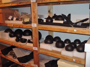
The development of SCUBA gear in the years following World War II has been both a blessing and a curse for the Valcour site. For many years, sport divers have recovered items found resting on the flat, silty bottom of the strait where the American line stood. Even though the lake’s cold and dark water aids in preserving artifacts submerged in it, enough time has passed so that organic items like cloth and leather have decayed away and iron items have rusted. Conversely, those items or parts of items that rest in the silt are much more protected from oxygen and will not have rotted or rusted nearly as much. Once they are brought out of that environment, however, they immediately begin to decay and rust so that, after some time, they are often nearly or completely gone. In addition to the loss of the artifacts, the context in which they sat is also lost when they are taken away by curiosity seekers. No longer can anyone try to determine an item’s role in the battle by its location. For those reasons, LCMM has for several years been active in educating the public, particularly sport divers, on the treatment of underwater sites.[8]
For the Valcour site, the education and professional exploration intensified in 1999 when Edwin Scollon, a diver for the New York State Police with an interest in the Valcour battle, discovered part of a cannon rising out of the silt during one of his recreational dives on the site. Shortly thereafter, the Lake Champlain Maritime Museum teamed up with a dedicated group of sport divers with an interest in underwater archaeology and the battle site to form the Valcour Bay Research Project (VBRP). The team set, among others, the towering goal of systematically mapping the battlefield.
Over the next six years, the project mapped nearly 200,000 square feet of the underwater site and located over 200 artifacts including several from the area where the Philadelphia had been raised in 1935.[9] The divers examining the area around the cannon located by Mr. Scollon discovered that he had actually found only a portion of the gun. Further exploration located another 22 pieces and subsequent research in primary documents uncovered the story of a cannon that had exploded on the gondola New York. By mapping the scatter of the artifacts related to the exploded cannon and incorporating it with the research information, LCMM has been able to develop a probable sequence of events and even the possible route of the gondola immediately before and following the explosion. The museum recovered and conserved many of those artifacts including all but the smallest fragments of the cannon. The major pieces of the gun and its story are now part of a display at the museum.[10]
During the first two years of the survey, divers brought significant items up to be measured and photographed before reburying them at the location where they had been found. More common items such as shot and unidentifiable fragments remained in place but did have measurements taken and locations plotted. In 2001, teams recovered a few items that then underwent study and conservation at LCMM’s Conservation Laboratory before being put on display at the museum.[11] Much to their surprise, divers found numerous fragments of exploded shells (hollow balls filled with gunpowder ignited by a fuse) as well as some unexploded examples. At the time, research had not given any evidence that the British ships had the mortars or howitzers that would fire such items. Subsequent investigation discovered that, indeed, some of the British gunboats engaged in the battle did have howitzers on them.[12] Another significant piece of information had been added to the story of the battle.
In the decade following those years of active exploration, funding for such things disappeared. Dive teams visited the site for a couple more seasons but could only conduct superficial surveys and do some mapping. Limited funding and permitting did not allow for close examination let alone recovery and conservation. There has been no organized exploration for the last few years and none is planned in the foreseeable future. So far, divers have surveyed about a third of the American line and none of the British position has been touched. There is still a lot to be learned from the underwater archaeology of the Valcour site.
Regrettably, with the science of underwater archaeology still decades in the future and interest in the artifacts solely for themselves rather than the story they could tell, Lorenzo Hagglund’s techniques wiped away some information. More information and artifacts disappeared through the lack of proper preservation and Hagglund’s gifting of artifacts to friends and influential people. One can only speculate as to what might have been added to the story of the Royal Savage, the Philadelphia, and the battle had more care been taken in the recovery operation. But, society has learned from the mistakes of the past and recent examination has added considerably to the story. One can hope that the examination will resume in the near future.
[Featured Image at Top: Detail of 1776 map showing the Battle of Valcour Island. Source: Boston Public Library]
[2] The Lake Champlain Maritime Museum has conserved and put on display two of the surviving ribs in their “Key to Liberty” exhibit.
[3] Discussion of the efforts directed at Ferris/Arnold Bay ships comes from Arthur Cohn, Lake Champlain Maritime Museum, Galley “Congress” Inspection Report (Washington, D.C.: Department of Defense, Naval Historical Center, 2001), 3-5.
[4] John Raymond Bratten, “The Continental Gondola Philadelphia” (Ph.D. diss., Texas A&M University, 1997), 121-2.
[6] Press-Republican (Plattsburgh, NY), 20 February 2001. http://blog.pressrepublican.com/archive/index.php?option=com_content&view=article&id=5380:royal_savage_not_up_for_grabs:_nobody%27s_asked_the_mayor&catid=34:news-articles (accessed 21 February 2014).
[7] The “Townsend Document,” created just days after the battle, is a return of information about the American ships including what happened to each of them. “Shipwrecks of Lake Champlain,” LCMM website, http://www.lcmm.org/shipwrecks_history/shipwrecks/spitfire.htm (accessed 15 February 2014). As of this writing, LCMM is in the process of co-publishing a genealogy of the Spitfire’s captain, Philip Ulmer.
[8] For example, see the museum’s discussion of underwater historic preserves at http://www.lcmm.org/shipwrecks_history/uhp/uhp.htm (accessed 3 March 2014).





6 Comments
Mike,
Great article on the work that Art Cohn, LCMM and its partners are doing to map out and research this important time in the lake’s history. Remember the flack that Sen. Leahy took several years ago when he equated Lake Champlain with the Great Lakes? He was right on as I can’t think of any body of water in the U.S.where there is so much vibrant history; I’m sure others will disagree, but as a fellow Vermonter, I think we can be excused for having a little bias! The Great Lakes may be bigger, but I submit that size does not always matter.
The Spitfire is also interesting for, as I understand it, its pristine condition. Specifically, the fact that it rests on the lake bottom with its mast still intact and pointing vertically upwards. Amazing! I haven’t yet, but have to get over to LCMM to see the artifacts you reference.
This will also be an important year for the lake as celebrations take place marking the bi-centennial of the end of the War of 1812 with the Sept. 11 (talk about a coincidence) Battle of Plattsburgh.
I well remember the Senator’s comments on Champlain being the sixth of the Great Lakes. Many may have taken the idea as a joke but the lake is probably THE greatest when it comes to colonial history. In any case, the discussion brought some attention to Champlain. By the way, Senator Leahy and his wife, Marcelle, are both divers and supporters of the Lake Champlain Maritime Museum.
I suspect you would enjoy a visit to LCMM. Be sure to talk to the folks in the conservation lab–one of very few labs world-wide where you can actually see work in process and talk with the technicians. You might also want to check out their website for special events and programs.
Thank you for this in-depth and fascinating discussion of the physical remains of those fateful days on Lake Champlain.
I grew up on the lake, and heard legends about Carleton’s pursuit of the Americans up the lake being delayed as his fleet stopped to bombard a rock (which, although marked on contemporary charts, bears a striking resemblance to a ship). Rust streaks still visible today and cannon balls said to have been recovered from the waters around it give credence to that legend.
That tiny island is known today as Carleton’s Prize, and my grandparents owned it for several years, before gifting it to the Lake Champlain Land Trust in 1978. The story of Carleton’s folly, and the strategic delay that it caused in his pursuit of the American forces formed the basis of my 2011 novel, The Prize, and it’s gratifying to see this little-known battle getting more attention and research.
Thanks again for the article!
Very much agreed with the importance of Lake Champlain and its rich history. I’d hazard that many Americans today outside of the New England/New York area are unaware as to just how complicated and integral the Champlain-Hudson corridor history has been to the country as a whole. Perhaps that too is even optimistic and falls particularly from my fingers because of my bias as a New Yorker. It has been explored on this site a few times just how vital the waterways of the state were in the Revolution, but even in the colonial era before that and in the fledgling Republic, New York’s waterways influenced the course of history.
So far as the excavation, it is great to have this information regarding the mapping of the lake, however it is always unfortunate to think of how much has been lost to scavengers and artifact hunters without recourse or understanding of technique. It also pains me that in bringing to the surface such evidence of history, often can destroy just that. What will be left for future generations?
David,
You bring up an important point regarding “artifact hunters.” As you probably know, there was a bridge connecting the land immediately below Ft. Ticonderoga and the Vermont shore on the other side at the base of Mt. Independence. It was over this that the retreating Americans fled when Burgoyne came south. It was apparently quite a structure and had large amounts of ballast around the pilings holding it in place and about fifteen years ago someone came and did some creative, and unauthorized, removal of whatever was down in the water. Not a good thing and we can only hope that the Spitfire and the other relics in the lake stay in one piece, as much as nature will allow them or that conservation efforts can provide.
The Spitfire should be quite secure from sport divers as it is in very deep waters requiring special gasses and equipment for divers to reach.
I probably shouldn’t say anything about the Mt. Independence-Ti bridge ’cause I would like to do an article about it sometime in the future but, what the hell. The remains of the Great Bridge have been and still are in danger of disappearing.
The lake is about a quarter-mile wide there and only a few fathoms deep making diving accessible to anybody. The one saving grace is that visibility at all times is only about four inches (Samuel de Champlain commented on the dirty water in 1609). In 1777, the Americans sank a series of caissons/piers that extended above the water and tied the floating bridge to them allowing easier communications between the two fortifications. With several thousand American, British, and German troops occupying the positions on both sides of the lake for two years, you can imagine how much stuff ended up on the bottom of the lake around there.
Commercial traffic in the 19th and 20th centuries tore out a couple of the piers but parts of most of them still exist on the bottom. Every once in a while, one of the logs works free and washes ashore. One is on display at the Lake Champlain Maritime Museum and a couple are in the museum on Mt. Independence.
For those really interested, one Scott McLaughlin wrote his master’s thesis about the underwater archaeology done on the bridge. You can access it by going to the Texas A&M website at http://nautarch.tamu.edu/pdf-files/, scroll down the list of documents until you come to McLaughlin-MA2000.pdf, and click on it. This summer, some more underwater archaeology will be conducted by divers from the Maritime Research Institute of LCMM. They will be checking the routing of an underwater cable to be laid down the middle of the lake so, regrettably, won’t be doing a whole lot but every little bit helps.