

In the months prior to the Revolutionary War’s culminating siege at Yorktown and Gloucester Point, Virginia in 1781, the embattled Old Dominion was the scene of an intense campaign of maneuvers and raids. These operations pitted the young Maj. Gen. the Marquis de Lafayette, commanding a small, hard-pressed but determined American force, against Lt. Gen. Charles, Lord Cornwallis, whose army of thousands of veteran Redcoats, Hessians, and Loyalists far outnumbered the lean American ranks in maneuvers that ranged from Virginia’s flat Tidewater region to the Blue Ridge Mountains, and from the Potomac to the Appomattox and James Rivers in May and June.
Lord Cornwallis led over 5,000 hard-marching troops across central Virginia, capturing and destroying Patriots arms, supplies, and tobacco to choke off logistical support going to the army of Maj. Gen. Nathanael Greene in the Carolinas. His hardy regiments had arrived in the beleaguered state in mid-May from coastal North Carolina and combined with British troops located at Petersburg. Earlier in 1781, Lafayette was ordered to Virginia by Gen. George Washington with about 1,000 Continental Army light infantrymen to provide the nucleus of a defensive force in Virginia to at least try to check the destructive British raids led by the traitor Benedict Arnold that began in early January. The marquis was also to be reinforced by local, often undependable, militia companies and a detachment of 1,000 Pennsylvania regulars led by Brig. Gen. Anthony Wayne, although the latter would not arrive in Lafayette’s camps from York, Pennsylvania, until June 10.
Lafayette saw in April, as soon as he crossed the tidal Potomac at Georgetown into Virginia, that his force was too paltry and poorly supplied to effectively counter Cornwallis’s army. At the time, Lafayette wrote, “was I to fight a battle I’ll be cut to pieces,” and if he were defeated, “the Country would think itself given up.” In short, he wrote, “I am not strong enough yet to get beaten.”[1] Consequently, he prudently retreated just out of reach of the advancing enemy, always putting his own understrength command behind a river to defend his small force from the British.
After a short rest at Petersburg, Cornwallis’s battalions crossed the James River to Westover Plantation on May 24-26, then quickly marched northward to burn and plunder at the small riverside villages of Newcastle and Hanovertown, and at plantations, farms, and warehouses along the way. The column finally stopped at Cook’s Ford along the banks of the North Anna River just northwest of the stately Hanover Courthouse on June 2. Lafayette managed to avoid being trapped by Cornwallis’s swift-moving battalions by constantly moving northward, hoping to soon combine forces with Wayne’s Pennsylvanian regiments then marching south from Northern Virginia. Realizing he would not catch up with the evasive Lafayette, the British commander decided to turn west instead, to destroy exposed rebel depots and military stores at Charlottesville, Point of Fork, Seven Islands, and Old Albemarle Court House. Cornwallis also wanted to disperse the Virginia Assembly then meeting at Charlottesville, and to capture Gov. Thomas Jefferson, then in residence at nearby Monticello.

During Lafayette’s harried movements to avoid the pursuing redcoats, in early June, the American force encamped at Wilderness Run Bridge in fields west of Fredericksburg (that would later become part of the 1864 Wilderness Battlefield), at the intersection of modern State Routes 3 and 20. There, on the latter highway at its junction with County Route 720, stands a Virginia Historical Highway Marker (OC-22) in Orange County that states in part:
In the campaign of 1781, the Marquis de Lafayette marched through the Wilderness to rendezvous with Brig. Gen. “Mad Anthony” Wayne. On 3 June 1781, Lafayette’s army camped south of the Wilderness Bridge across Wilderness Run from Ellwood. The next day, Lafayette reconnoitered Ely’s Ford while the army crossed Germanna Ford to reach Culpeper Church.
This marker was erected in 2009, with text based upon research conducted and submitted to the Virginia Department of Historic Resources by outside researchers (and not by DHR employees).
This standard silver and black painted marker’s accuracy and the research behind it are problematic due to its message that states, “Lafayette reconnoitered Ely’s Ford while the army crossed Germanna Ford to reach Culpeper Church.” First, some simple geography. From the American army’s camps along Wilderness Run, Lafayette wisely decided to move north across the Rapidan River on June 4 to avoid the nearby enemy. There were two options for a river crossing: Germanna Ford (on today’s Route 3) to the northwest of Lafayette’s position, and Ely’s Ford to the north (on modern Ely’s Ford Road, Rt. 610). Marker OC 22 implies that while the Marquis (and presumably his staff) considered using Ely’s Ford three and a quarter miles away as the crow flies, the army in fact crossed the Rapidan at Germanna Ford, about five miles distant on the road to Culpeper.
The claim in favor of Germanna Ford as the Rapidan Crossing site is for the most part based on a map of Virginia titled Campagne en Virginie du Major Général M’is de LaFayette (The Virginia Campaign of Major General the Marquis de LaFayette), drawn by Lafayette’s long-serving aide-de-camp Michel Capitaine du Chesnoy, showing the routes of the forces of the marquis and Cornwallis during these 1781 operations. This large map was created in 1781; it was never published. It shows Lafayette’s troop movement across the Rapidan at Germanna Ford, thus the marker researchers concluded that the map could be used conclusively to make their claim in the sign’s text.[2]
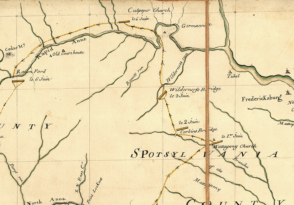
In the Virginia Department of Historic Resources files supporting the highway marker’s language, the researchers correctly state that almost all publications going back to the nineteenth century state—and show on maps—that Lafayette’s army used Ely’s Ford to move across the Rapidan. This assertion by previous scholars was based on available documents (discussed below) that supported an Ely’s Ford location, not Germanna Ford. The marker researchers claim that this is because, prior to the acquisition of the Chesnoy map by the Library of Congress in 2000, it was “not available to scholars.” This assertion, however, assumes without comment that there were no other copies of the map produced at any time since its creation, and that the map’s previous owner(s) did not make it available to researchers in the past. In fact, “in 1956 Yale University purchased Lafayette’s personal copy. . . . This version was enhanced with decorative elements that are lacking on the two other examples.” Facsimiles were produced soon thereafter and were available to researchers. Moreover, Colonial Williamsburg acquired a copy of the map in 1930.[3] Thus the claim that the map was unavailable to researchers until 2000 is demonstrably incorrect.
The OC 22 marker researchers also claim that “the conflict” between the Chesnoy map and contemporary documents “can easily be explained by the fact that the army marched on foot while Lafayette as a Major General and commander of the army road on horseback.” The army, they posit, marched on foot twelve miles to their next camps at Culpeper Church via Germanna Ford, whereas the mounted marquis rode twenty-four miles on horseback via Ely’s Ford to reach the same church. They also write extensively on how far troops typically marched in the Revolutionary War, and rely upon “Ellwood [House] Myths,” modern Marine Corps publications, and other tangential sources to support their conclusions. However, they leave out several key pieces of evidence that undermine their claims and ignore other sources.
The marker’s research files do not rely on much direct evidence, and beg a number of questions, the primary example being the notion that Lafayette ordered his weary soldiers to march along the shortest route to Culpeper Church, but that he rode twice as far to reconnoiter Ely’s Ford. If he had already sent his troops west to cross at Germanna, why would he then need to reconnoiter Ely’s Ford? A military reconnaissance is conducted before a movement, so that a commander can make a sound judgement about a planned operation. A commander simultaneously making a reconnaissance in the opposite direction of his troops when they are already on the march makes no military sense. Would Lafayette have abandoned his marching column to look over a ford his troops would not use? Of course not; the marker’s text indicates an unfamiliarity on the researchers’ part with how eighteenth-century armies operated in the field. Moreover, it can be reasonably argued that with so many local Virginia militiamen with and around the army, it would have been unnecessary for the Frenchman to personally reconnoiter either of the fords. Thus, the notion that “Lafayette reconnoitered Ely’s Ford” while his foot soldiers used a different crossing is illogical.
And the researchers apparently did not recognize that Lafayette’s strategy had consistently been to keep a river obstacle between his own troops and the British since the latter crossed the James River in late May. Each time the British drew closer to his camps Lafayette retired to higher ground across rivers: the South Anna, the North Anna, the Po, and then the Rapidan. “Lafayette continued to retreat from river to river,” as his early twentieth century biographer described it. So why would it make sense for Lafayette to use Ely’s Ford for the entire army? From his soldiers’ camps at Wilderness Run, it was a march of less than five miles to the Rapidan at Ely’s Ford. A crossing there would have placed the American army at a location not only to meet Wayne’s oncoming reinforcements but also to defend Fredericksburg, where Patriot stores and a forge were located.[4]
In short, the main contemporary evidence that points to a Germanna Ford crossing site is the Chesnoy map. It is the only document cited in the marker research files to support this claim. Only one other document has been found by this author supporting a Germanna Crossing, a pension application made in 1833 by a Viriginia militiaman serving in the 1781 campaign. However, the surviving correspondence of Lafayette and Cornwallis make no mention at all of the use of Germanna Ford to cross the Rapidan at this or any other time.[5]
Let us again consider the Chesnoy map which points to a Germanna Ford crossing location. Is it reliable? This map shows no American troops crossing at Ely’s Ford, but this cartographic representation is false—we do in fact know that American troops crossed at Elys Ford by extant records described below. Thus, the reliability of the map must be called into question at least to a degree in connection with the question about the Rapidan crossing site. Put simply, since the map is inaccurate regarding Ely’s Ford, it could just as easily be inaccurate as to Germanna Ford. Perhaps a handful of officers crossed at Germanna Ford, including Lafayette’s cartographer, which could explain the anomaly of the 1781 campaign map.
Evidence to support the conclusion that Lafayette’s troops waded across the Rapidan at Ely’s Ford is not hard to find. For establishing the marker text, the researchers seem not to have used several key documents, all of which refute the assertion that the main Patriot force in the Piedmont marched to Germanna Ford to pass over the Rapidan River. A review of these key sources follows below.
Enoch Breeden, a drafted King William County militiaman, stated in a pension application that in the spring of 1781, his “regiment joined General [Edward] Stevens command, at four mile Creek in Henrico County and from there the troops retreated from the British, through Hanover, and Spotsylvania Counties into Culpepper County, crossing the Rappahannock [by which he meant the Rapidan; the two rivers join several miles downstream] at Elys ford.” He added “the whole under the Command of General Lafayette.” The last statement likely means that all of the marquis’s troops used Ely’s Ford to cross into Culpeper County.[6] Similarly militiaman William Leckie of Caroline County, Virginia, who served as a substitute on a three-month tour, clearly recalled that the American army at this time “retreated to Ely’s Ford upon the Rappahannock [Rapidan], the British pursuing, we marched through the wilderness into Culpeper County.”[7]
A particularly important source is a brief letter sent from William Constable, a Continental officer in the 9th Virginia Regiment and an aide-de-camp to Lafayette, to Capt. Thomas Drew, a long-serving Virginian from Caroline County. The June 4 letter was written from the army’s hasty camps along Wilderness Run. Because the message was intercepted by roving British dragoons, which “so outflank us . . . we can do nothing,” it was kept in British post-war archives with other papers related to the campaign. Notably, Constable wrote, “we will cross at Ely’s Ford today [emphasis added] to join Wayne,” whom they expected to join them with his Pennsylvanians any day.[8] This captured letter clearly states the army’s intention to move north to cross the Rapidan River at Ely’s Ford.
The most decisive evidence that Lafayette’s army crossed the Rapidan at Ely’s Ford comes from a Viriginia militiaman’s enlightening pension application. Forty-year-old Edward Elley was born in Culpeper County in 1751, and eventually settled near Ely’s Ford, in the same county. He was no doubt related to the farming family for whom the ford was named. He served actively during several tours of militia duty during the war, including the autumn Yorktown campaign. He recalled that in 1781 in “the third term I was drafted for the service[,] I hired a substitute who filled my place and [who] was in General Lafayette’s Army when he passed [i.e., crossed] on by Elleys ford in Culpepper County Va by circuitous rout[e] through Spotsylvania County and into Culpepper in order to strengthen his Army.”[9] Note that Elley’s recollection specifically states the American force made a circuitous route into Culpeper County by crossing at Elys Ford, which undermines the historical marker researchers’ conclusion that the troops went directly to Germanna and that only Lafayette made the longer reconnaissance to Elys Ford. Perhaps most definitively, Elley states that the army marched through Spotsylvania County to arrive at the ford; if the troops had crossed at Germanna they would have been marching in Orange County.
Elley also wrote that “whilst passing Elleys ford some fifty or sixty of Lafayettes officers and soldiers called at my house near said ford and [I] gave them dinner it being that time of day when the army passed.” To feed the hungry troops he “killed four or five lambs for the occasion & they were cooking and eating until night from common dinner time[.] they then left in pursuit of the army.” Note that Elley says these troops left the ford after their roasted supper to follow the army, clearly revealing that the rest of Lafayette’s troops had already crossed at Elys Ford into Culpeper. He also wrote that he saw “officers and soldiers,” which shows this was not just a staff reconnaissance.[10]
As detailed above, existing documents demonstrates with a preponderance of evidence that Lafayette’s army crossed into Culpeper at Elys Ford to avoid Cornwallis’s onrushing troops. Using Chesnoy’s map, several letters, militia pension applications, and a critical review of the information used to create historical marker’s content, it becomes clear that the 2009 highway marker on Route 20 regarding the June 1781 crossing of the Rapidan River is incorrect.
[1] Lafayette to George Washington, May 24, 1781, in Stanley J. Idzerda, Lafayette in the Age of the American Revolution—Selected Letters and Papers, 5 vol. (Ithaca, NY: Cornell University Press, 1981), 4:131.
[2] The map can be seen at www.loc.gov/item/00558784/.
[3] Campagne en Virginie du Major Général Misr de La Fayette was drawn by the French topographical engineer Michel Capitaine du Chesnoy, Colonial Williamsburg, emuseum.history.org/objects/10017/campagne-en-virginie-du-major-general-misr-de-la-fayette?ctx=685fcd216fd3b2ceb2a5757be93caf0d7529f070&idx=2.
[4] Louis Gottschalk, Lafayette and the Close of the American Revolution (Chicago: University of Chicago Press, 1942), 241.
[5] Pension Application of James Brown Rice R8746, revwarapps.org/r8746.pdf.
[6] Pension Application of Enoch Breeden, S1747, revwarapps.org/s1747.pdf
[7] Pension application of William Leckie W25, revwarapps.org/W25.pdf.
[8] Ian Saberton, ed., The Cornwallis Papers: The Campaigns of 1780 and 1781 in the Southern Theatre of the American Revolutionary War, 6 vols. (East Sussex, UK: Naval and Military Press, 2010), 5:264.
[9] Pension application of Edward Elley S8403, revwarapps.org/s8403.pdf.
[10] Ibid.


One thought on ““We Will Cross at Ely’s Ford Today”: Is the Yorktown Campaign Historical Marker at the Right Location?”
Persuasively argued and supported!