


Everybody has heard of Fort Ticonderoga on Lake Champlain. On the other hand, mention Mount Independence and one usually encounters the puzzled lowering of eyebrows and cocking of the head to the side. Most will be quite surprised to learn how that rocky thumb of land on the Vermont shore opposite Ticonderoga actually played a role in the Revolution arguably far more significant than that of the well-known fort.
Geography
In the days before the automobile, the Hudson River, Lakes George and Champlain, and the Richelieu River formed a water highway between New York City and the St. Lawrence River near Montreal. People could travel by water all but about twenty-five miles of that 350-mile-long route. In addition to providing a convenient corridor for movement, it opened an enormous area of land to human exploration, development, and centuries of conflict. [1]
Much of the struggle centered on the junction of the two lakes. Lake George lies to the south of Lake Champlain and drains through the three-mile-long LaChute River into South Bay, the southward extension of Champlain.[2] The peninsula on the northwest corner of this confluence is a bluff that stands nearly 100 feet above the waters. On the eastern shore directly opposite the mouth of the LaChute is a larger and higher peninsula formed by the junction of East Creek with South Bay. Between these two peninsulas, South Bay is only a quarter-mile wide forming a very tight choke point in the lengthy water highway.

Native American Use
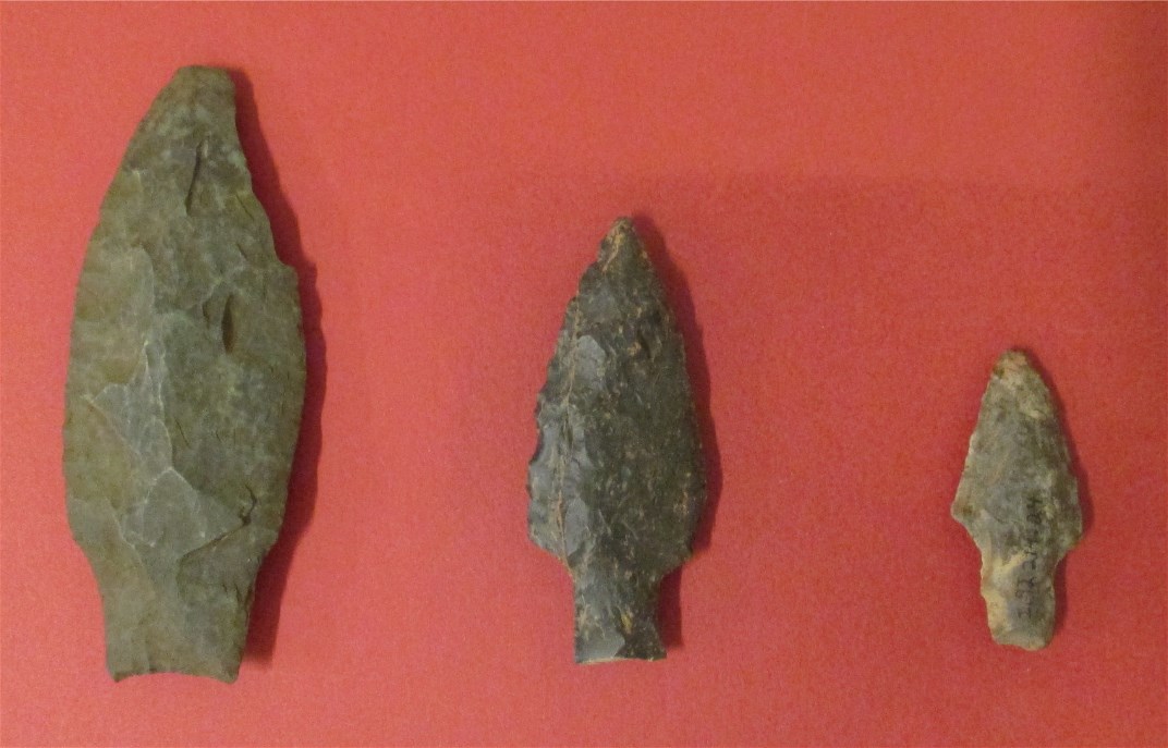
Nobody knows when the first humans entered the Champlain valley but, by the time of the first contact with Europeans, the area had been home to various tribes of native peoples for at least nine thousand years. On the eastern peninsula, they discovered a vein of chert that provided them with tools and weapons for their own use and for trade. Items made from that chert have been found at sites across Vermont, New Hampshire, Massachusetts, and Quebec. Native Americans continued to utilize both peninsulas well into the eighteenth century when the arrival of European settlers drove them out of the valley.
Europeans
In 1609, Native American guides brought Samuel de Champlain south from Canada to explore the lake. Over the next 150 years, French settlers slowly moved into the northern half of the valley. Eventually, the old European animosities between France and England carried over to the Americas and both sides began to fight over control of the water highway.
Little changed in the valley until the French and Indian War. In 1755, the French built a fortress named Carillon on the western peninsula which allowed them to control the highway until the English captured the fortress in 1759 and renamed it Ticonderoga. With the arrival of peace in 1763 putting an end to French control of Canada, the English had little need for Ticonderoga but did maintain a small garrison there.
The Revolution
Just three weeks after Lexington and Concord, Lake Champlain became an active front in the war. On May 10, 1775, Ethan Allen with the Green Mountain Boys and Benedict Arnold captured the sleeping garrison at Ticonderoga. The rebelling Americans now controlled the water highway. More men arrived and, in August, a small army invaded Canada. British reinforcements arrived in the spring of 1776 forcing the depleted invading army to abandon their efforts. The Americans slowly retreated out of Canada and reached Ticonderoga in early July.
Ticonderoga had gained quite a reputation during the French and Indian War. It began in 1758 when a British force suffered two thousand casualties during a failed attack against a much smaller French garrison. The lore continued to grow and the next year a British and American force prepared for a very difficult siege. However, the fort fell without a shot because the small French garrison abandoned it. In spite of withstanding only one attack, Ticonderoga’s legend had been born.
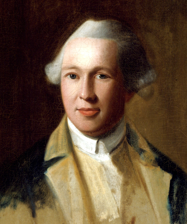
For the Americans in 1776, however, Ticonderoga had a serious problem. The French had built Carillon to protect against an attack from the south but the threat now sat to the north. In early July, Jeduthan Baldwin, an engineer, and a staff officer named John Trumbull crossed South Bay to visit the north-facing forest-covered peninsula on the Vermont side of the lake.[3] With a clear view down the lake, that rocky ground offered a much better counter to a British move up the lake from Canada.[4] It had water on three sides, cliffs or steep rising ground almost all the way around, and its higher elevation commanded the works at Ticonderoga. It looked to be an easily defensible position so Baldwin’s men began clearing a road and digging a well.[5] Work on the nearly 400 acres would continue for the next sixteen months.
By the end of July, hundreds of men had made camp on the peninsula. On July 23, a copy of the Declaration of Independence reached Lake Champlain and on the following Sunday Colonel Arthur St. Clair read it to the troops. From that day on, the place called Cap du Diamont by the French and the far less flamboyant Rattlesnake Hill or East Point by the English and Americans became known as Mount Independence.
Over the next few weeks, a steady flow of reinforcements arrived. By October, the garrison for Mount Independence and Ticonderoga had grown to over 12,000 men making the complex the fourth largest population center in America behind Philadelphia (34,000), New York (22,000), and Boston (15,000). With soldiers from New England, New York, New Jersey, and Pennsylvania, regional conflicts could not be avoided so, with some exceptions necessitated by the demands of military efficacy, units from New England lived on the Mount. Housing consisted of windowless log huts, shelters made of bark and slab wood from the sawmill on the LaChute, or tents. Senior officers often built small post and beam houses with windows. On the high ground, Baldwin’s crews built a square of two-story post and beam barracks sufficient for eight hundred soldiers.[6]
The men began building fortifications as well. A breastwork with embrasures for cannons curved some 300 yards around the shore of the northern end of the Mount. Two hundred yards back and eighty feet higher up sat the Grand Battery (today called the Horseshoe Battery because of its shape). Overlooking East Creek, the Americans constructed lines of felled trees and logs studded with dozens of emplacements for men and cannons. Wanting a central strong point, Baldwin had his men erect a picket wall around the barracks, a few smaller buildings, and a well on the high ground. Encompassing over four acres, the wall had the shape of an eight-pointed star and thus became known as the Star Fort. With the addition of scores of other defensive works, store houses, artificer workshops, magazines, sutler shops, hospitals, etc., the Mount must truly have looked like a crude city growing out of the shallow soil.

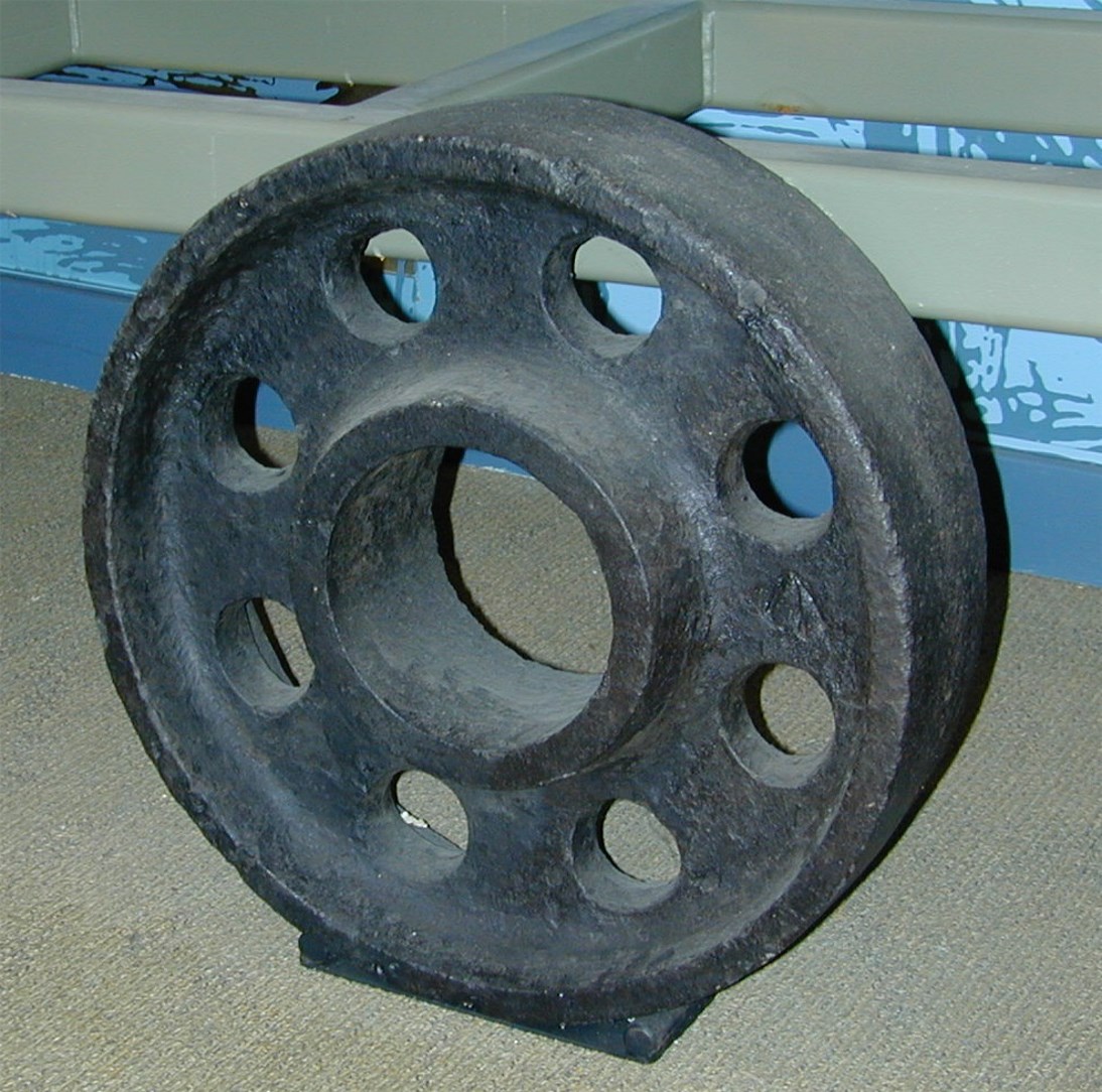
During all of this activity, the men made two valuable discoveries. Just as the Native Americans had done thousands of years earlier, the Americans found the chert but, instead of projectile points and tools, they began producing gunflints. In addition, they discovered several outcroppings of sulfur which could be used for both medicine and making gunpowder.
While the Americans worked on their camps and fortifications, the British worked on a fleet at St. John, a major position at the outlet of Champlain in Canada. An arms race developed with the American army building ships at Skenesborough (now Whitehall, New York), fitting them out with cannon, crew, and supplies at Mount Independence and Ticonderoga, and sending them down the lake under the command of Benedict Arnold. The two fleets met on October 11 at Valcour Island. Arnold’s out-gunned and out-classed fleet tried their best but lost two-thirds of their ships and the British came away with control of Lake Champlain. They would not relinquish that control for the duration of the war.
The victors moved on to face the American army at Mount Independence and Ticonderoga. They scouted the area, noting the thousands of men and scores of cannons behind defensive positions with flags flying. Communication and movement between the Mount and Ticonderoga had been improved by the construction of a floating foot bridge allowing men and equipment to quickly move from one post to the other. Finding the enemy strongly entrenched and winter fast approaching, the British returned to Canada in early November having accomplished their goal of gaining control of the lake.
With the threat of attack now gone, most of the American garrison, including engineer Baldwin, either went home or left to join Washington’s army in New Jersey. Soon, only one-fifth of the thousands of men remained under Col. Anthony Wayne. Less than 700 manned the extensive works on Mount Independence. The numbers continued to diminish as some died from disease and others left when their enlistments expired. By February, only 1200 men, including the sick, remained to garrison both the Mount and Ticonderoga.[7]
To everyone’s delight, reinforcements began to arrive towards the end of February. Baldwin also returned with orders to build a larger bridge, a main hospital, a new fort, and several smaller facilities on the Mount.[8] He immediately set to work on the bridge constructing twenty-two piers that rested on the bottom of the lake.[9] He planned for the bridge to sit atop the piers but, for the time being, put together a fourteen-foot-wide floating bridge and attached it to the sides of the piers to also serve as a boom to keep enemy shipping from passing through the narrows.
He did not ignore the other planned construction. On the southwest corner of the high ground, he began construction on a two-story hospital two-hundred-fifty feet long by twenty-five feet wide. Below the western cliffs, the men created a huge garden and, on top, built a crane to lift supplies up the one-hundred-twenty foot cliff face.
Administrative help arrived as well. Gen. Enoch Poor took over command and Tadeusz Kosciuszko, a Polish engineer, arrived to help Baldwin. These new arrivals found everything in short supply, particularly manpower. With a defensive perimeter of at least five miles the complex needed a garrison of several thousand men. Congress, however, viewed Washington’s situation around Philadelphia and New York more important and did not believe the British would move out of Canada, so the Champlain posts saw little support. By late May, the garrison for both Mount Independence and Ticonderoga consisted of only 2900 officers and men, 10,000 less than in 1776. It would increase by only 300 in the coming weeks.
Yet another commander, Arthur St. Clair, arrived on June 12 and found a discouraging situation. The bridge, hospital, and many of the defensive works lay incomplete. St. Clair felt that Congress, the public, and many of the troops on Lake Champlain had put far too much faith in Ticonderoga’s reputation and had been “fooling away time” working on that side. The more valuable Mount Independence positions had been neglected.[10] To add to the sorry circumstances one of the regiments went home, depleting the already small garrison to around 2500. St. Clair must have been rather depressed when he wrote, “every thing is so much out of order.”[11]
The general officers gathered in a council and agreed to concentrate their efforts on Mount Independence. Seeing the southern end of the Mount as a weak point, men repaired the existing breastworks and built three artillery batteries overlooking the approach. The army also moved equipment and supplies not necessary for Ticonderoga’s defense over to the Mount. All this activity began to create a positive atmosphere at the posts, but that would soon change.
Around the same time as St. Clair’s arrival, British Gen. John Burgoyne began moving up Lake Champlain with 8,000 men. Lacking sufficient manpower to hold the outlying positions, St. Clair withdrew into the main works. In the first days of July, Burgoyne cut off the American retreat route via Lake George while a large force of Germans began the move to cut off the route through Vermont.
St. Clair considered his options: Should they try to hold as much ground as possible? Should they abandon Ticonderoga and try to maintain Mount Independence? Should they retreat? The British added to St. Clair’s quandary on a day that should have been one of celebration for the Americans, July 4. Cutting their way through the forest on the west side of steep and rocky Sugarloaf Hill, the 800-foot-high ridge separating Lake George from South Bay, a British party had begun to build an artillery battery overlooking all of the American positions.
In 1776, there had been some question as to whether or not shot from artillery on Sugarloaf Hill could actually reach the American positions. Trumbull conducted an experiment designed to answer the question. From the tip of Mount Independence and the glacis of Fort Ticonderoga, Trumbull fired cannons at the summit of the hill. Shot from both cannons came close enough to prove that the American positions could be hit.[12] In 1777, however, with far fewer men than the year before, the Americans did not have the troops to man a position on the hill. Soon the British would be able to bombard the Americans at their leisure. Worse yet, they could see every move the Americans made.
On July 5, after debating the options, a council of officers agreed to retreat and in the first hours of the morning of July 6 the American army abandoned Mount Independence and Ticonderoga, leaving the majority of the artillery and supplies. The German Prinz Friedrich and British 62nd regiments occupied the posts while the rest of Burgoyne’s army pushed on in pursuit of the fleeing American forces. In mid-August, the ailing British 53rd Regiment replaced the 62nd which joined Burgoyne.
The new occupiers of the Mount continued the work of fortifying the position and felt rather secure with Burgoyne’s army to the south, control of the lake, and friendly territory behind them.
The Americans threatened that security in September, however. A two-pronged attack under Col. John Brown captured all of the outworks around Ticonderoga and made prisoners of over 200 British soldiers. At the same time, they freed over 100 men held by the British. In a bit of irony, the Americans who captured the battery on Sugarloaf Hill used the cannons installed there to bombard Ticonderoga. On the Mount Independence side, an attack on the southern end did not make much headway so the Americans broke off the action. Brown demanded the British surrender but without success and, lacking adequate artillery for a prolonged siege, the Americans left after a few days.
The British and German occupation would not last much longer, however. Shortly after Brown’s little army attacked Mount Independence and Ticonderoga, Burgoyne surrendered his army. Three weeks later, the Crown forces at Mount Independence and Ticonderoga destroyed what they could and moved back to Canada.
Over the remaining years of the Revolution, parties from both sides spent short periods at the Mount but neither side tried to establish a permanent occupation. The tumultuous time for Mount Independence had ended.
Post-Revolution
With the armies gone, the Mount returned to its natural state. Farmers tried to work the shallow rocky soil but abandoned most of their efforts, leaving maple sugaring and occasional logging as the only agricultural activities. Hiking and picnicking became common and as people found more leisure time in their twentieth-century lives, camps and a marina popped up along the shore. Few of these people knew much of the Mount’s story.
But some did not forget the history. In 1911, the Pell family, in conjunction with their efforts at restoring Ticonderoga, purchased 113 acres encompassing the northern section of the Mount and the state of Vermont began the process of purchasing the remaining land in 1961. Mount Independence is now a Vermont State Historic Site covering over 300 acres and is jointly managed by the Vermont Division for Historic Preservation and the Fort Ticonderoga Association.
The first steps in sharing the location’s story began in 1966 with the beginning of a trail system. Since then, the trails have expanded and now wind for over six miles—about a quarter of it handicap-accessible—taking visitors through woods and meadows past the remains of hut sites, building foundations including the hospital and blockhouses, artillery batteries, the Star Fort, and grand views of Lake Champlain and Fort Ticonderoga. A museum finally opened in 1996 to give visitors a more detailed look at the history.
Archaeology
The intense endeavors of thousands of people for a year and a half left a treasure trove of indicators of their presence. Vermont sold off the large pieces of iron and steel in the nineteenth century and pot-hunters have a taken their toll but, because of minimal human activity over the centuries since the Revolution, much still remains. As a result, Mount Independence has been called “the most intact Revolutionary War site in America.”[13]
Shortly after Vermont began buying the land, an organization called the Mount Independence Associates sponsored a survey of the Mount. Three Middlebury College students prepared a detailed surface map and plotted nearly 150 potential archaeological features but they did not conduct any excavations. The first authorized archaeological digging took place over a two week span in 1975 when a small crew explored a potential site for a visitor center.
Extensive archaeological work took place during the summers of 1989, 1990, and 1992. A team of professional archaeologists, students, and volunteers led by Dr. David Starbuck dug test pits in nearly thirty huts and houses, barracks sites, a storehouse, two dumps, one of the blockhouses, a battery, and five lookouts. Over two centuries of Nature’s and farmer’s work as well as curious hands had scattered much of the vestiges of these once busy locations leaving only low mounds of stone hidden to all but the practiced eye. Once uncovered, however, they offered up some fantastic clues to the lives of the inhabitants.
While the crews investigated a few features spread around the site, most work concentrated on the second brigade encampment on the southwest corner of the Mount. Diggers uncovered sherds of all sorts of pottery, large numbers of nails, animal and fish bones, flints, shot of all sizes, gun parts, buckles, cuff links, pieces of wine glasses and window glass (the last two hinting at possible officers’ quarters), military and civilian buttons including ones from the American 5th, 12th, 22nd, and 25th Regiments and one from the British 47th Regiment that served with Burgoyne—the list goes on. The most ubiquitous item turned out to be bottle glass—diggers found it everywhere.
A few other sites also attracted attention. A blockhouse on the southern end provided little in the way of artifacts which may support documentary indications that construction had not been completed. It did, however, feature a large fireplace in the center that opened on two sides hinting that it might have been intended as a residence. The ground surrounding a possible storehouse yielded thousands of beef, pork, and fish bone fragments, the analysis of which gave some indication of butchering practices.

Crews also worked on five hut sites and a dump in the area of an artillery battery on the south end of the Mount. One hut site had a brick fireplace and contained several artifacts including lead net sinkers, musket balls, and sprue, the latter probably from casting shot. Diggers found two-dozen pieces of two kidney-shaped canteens, an iron pot hook, buttons, nails, pieces of wine bottles (of course), cow, pig, and sheep bone fragments, nut shells, dozens of sherds of a mug, and a piece of delft ceramic.
Everyone wanted to see what would be found in one other major feature—the main hospital. At two-hundred-fifty feet long, twenty-five feet wide, and two stories high, it exceeded all other structures in size. Crews dug nearly seventy pits inside the foundation but came up with very limited artifacts of a medical nature. This scarcity verified research that indicated both the Americans and British took all their medical supplies with them when they left. Other artifacts and what appeared to have been four large fireplaces suggested that at least part of the building had been completed but a lack of glass hinted that windows had not been installed. Melted bottle glass supported documentation that the building had been burned by the British.
Overall, most of the finds came as no surprise but crews did uncover some quite unusual items. For example, one crew found a button from the British 40th regiment which is unusual since that regiment did not serve in the Champlain valley.[14] The dump site yielded a fragment of a bottle that fit together with another fragment found in a hut site over five hundred feet away. The dump also produced a one-half real coin of Spanish origin. A hut site featured nearly all the pieces of a plate strewn out over a few feet as though someone had thrown it out the door like a Frisbee. The team working in the storehouse found four prehistoric projectile points inside the structure, possibly collected by one of the soldiers. While working on a hut site north of the hospital, the crew noticed a depression adjacent to the foundation. When they dug test pits, they discovered hundreds of bones, almost all of them leg bones from cows. One bone showed saw marks under a microscope, the only example found on the Mount of a saw being used in butchering.
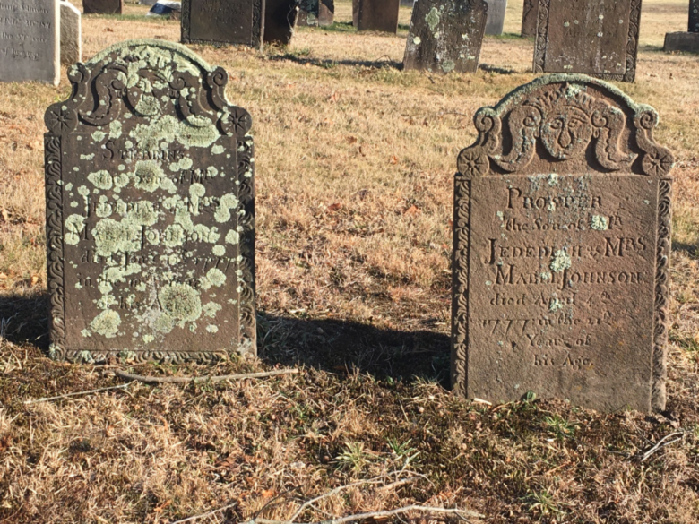
Each item, whether common or unusual, gave a clue about the lives of the people who lived on Mount Independence. Examination of the artifacts in the lab and subsequent research has added significantly to our knowledge of the Mount. No item connected us with an individual, however, except for one. While working on a hut near the battery, the crew unearthed a wine bottle inscribed with “James Hill 1777.” Research into men with that name who served on the Mount has indicated this James Hill probably came from Charlotte, Vermont. By connecting that bottle with an individual, it might well be the most powerful of all those collected.
Since 1992, very limited archaeological digging has been conducted. Each spring for the past few years, a team of professional archaeologists, staff, and volunteers led by Elsa Gilbertson, the regional administrator for the Division for Historic Preservation, has conducted a “walk-over” of a limited area of the Mount. As small groups explore their assigned areas, they use GPS to note any possible features which are then plotted onto a base map. The feature is not disturbed but, should the decision be made in the future to conduct archaeological exploration, these notations will provide some direction as to where to dig.
The people working on the archaeology of the Mount had another significant impact on the site over and above the artifacts. Under the direction of one of the amateur archaeologists, Bernie Noble, several people formed the Mount Independence Coalition (MIC), a 501c3 organization created to help the site raise private and public funds and to conduct activities. MIC is now an integral part of the site’s operations. Membership is open to anyone interested.
Conclusion
Mount Independence is a National Historic Landmark and 2016 marks the 240th anniversary of the site’s development by the American army, the 50th anniversary of the creation of the site’s trail system, and the 25th anniversary of the opening of the museum. It experienced a period of intense activity but, even though of critical importance for those months, it then became almost forgotten for over two centuries. It remains a treasure largely unknown to many historians. Those who take the time to unhurriedly tour the site and look for the subtle signs of human activity will be well rewarded. The imagination soon turns the wilderness into a setting bustling with activity. Visitors can almost hear the stirrings of the American Revolution around them.
[1] In addition to its human history, Mount Independence also has some noteworthy natural history features that are beyond the scope of this article. Worthy of note, however, are the several distinct micro-climates each with its own variety of plant life including a number of endangered species. The Mount also is a great place to go bird-watching, particularly in the spring when birds are migrating along the Champlain flyway.
[2] Technically, the south end of Lake Champlain is twelve miles north at Bulwagga Bay by Crown Point. In the eighteenth century, people often referred to South Bay as “the river.”
[3] John Trumbull would go on to become one of the most famous artists of the period. His best known works include “Death of Montgomery in the Attack on Quebec” (painted 1798), “The Declaration of Independence” (painted 1819 and used on the back of the modern two-dollar bill), “Surrender of General Burgoyne” (1821), and “Surrender of Lord Cornwallis” (1820)
[4] Lake Champlain flows north so moving south is going up the lake.
[5] With South Bay being slow-moving and continually cloudy, people considered the water to be unhealthy. As a result, the army opened a number of wells on the Mount.
[6] For more details on living conditions, refer to the article “Winter Soldiering in the Lake Champlain Valley.”
[7] Ebenezer Wild, “Journal of Ebenezer Wild,” Massachusetts Historical Society Proceedings 6 (1890-1891), 86;
Anthony Wayne, Orderly Book of the Northern Army, at Ticonderoga and Mt. Independence (Albany, NY: J. Munsell, 1859) 172-3; Ebenezer Elmer, “Journal Kept during an Expedition to Canada in 1776,” Proceedings of the New Jersey Historical Society 3 (1848), 46; Charles H. Lesser, ed., The Sinews of Independence (Chicago, IL: University of Chicago Press, 1976), 41.
[8] Jeduthan Baldwin, The Revolutionary Journal of Col. Jeduthan Baldwin 1775-1778 , ed. Thomas Williams Baldwin (Bangor, ME: The DeBurians, 1906), 97.
[9] The piers had a pyramid shape with platforms inside that workmen filled with rocks. The men built many of the piers on the frozen lake and then cut the ice away to allow the structure to sink.
[10] Arthur St. Clair, letter to Horatio Gates, 27 June 1777, Reel #4, Gates Papers, New-York Historical Society, New York, NY.
[11] Arthur St. Clair, Proceedings of a General Court Martial, … for the Trial of Major General St. Clair (Philadelphia: n.p., 1778), 16-17.
[12] John Trumbull, Sketch of the Life of John Trumbull, Written by Himself, 1835 (New Haven: B.L. Hamlin, 1841), 29-32.
[13] David Starbuck, The Great Warpath: British Military Sites from Albany to Crown Point (Hanover, NH: University Press of New England, 1999), 124.
[14] A shipment of uniforms for the 22nd and 40th Regiments was captured in August, 1775. The Pennsylvania Committee of Safety had control of them so some might well have ended up on the backs of Pennsylvania soldiers serving at Mount Independence or Ticonderoga. E-mail exchange with Roy Najecki, an independent researcher who recreates the 40th Regiment, March 7, 2016.


12 Comments
I greatly enjoyed this article, Michael, and also recommend that a visit to Mount Independence is a great experience. Anyone visiting the much better known Fort Ticonderoga should make sure to include the Mount in their visit. From some research here in New Jersey I have been interested in the New Jersey troops involved in the 1776 northern campaign. I have also had a long interest in Valcour Island and other Lake Champlain topics, frequently visit the Maritime Museum on trips to Vermont, and have appreciated and learned a great deal from your work. Thanks.
Very informative article, Mike! I will take the opportunity here to let readers know that the Mount Independence Coalition is currently producing a book about the Mount which is scheduled for publication in 2017. The book will include numerous maps and illustrations, including original works by the well-known historical artist Gary Zaboly, along with many interesting details about the history of the Mount. As Mike points out, the site is virtually unspoiled and offers a very rewarding experience for a visitor, including a state of the art visitor center. There are over 6 miles of walking and hiking trails winding past Revolutionary era batteries, blockhouses, the general hospital, barracks and soldier’s huts, with spectacular vistas of Lake Champlain and the surrounding countryside. The place is indeed a gem.
Very much liked this Article. I was researching my ancestor who was there in 1776 and 1777 as an officer in the 3rd NH regiment (2d Continental). They were part of the Second Brigade in 1776.
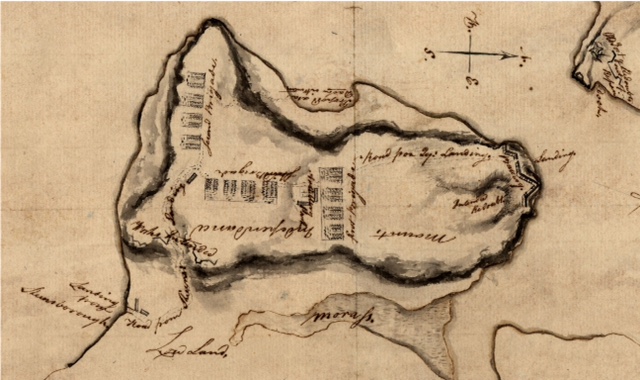
I recently found a detailed map in David Rumsey’s online collection. It was done by the British shortly after taking over in 1777.
http://jcb.lunaimaging.com/luna/servlet/detail/JCBMAPS~1~1~2703~101233:Plan-of-Ticonderoga-and-Mount-Indep
Glad you folks liked the article and hope you learned something. If anyone wants a tour of the place, I’d be happy to take you around.
Charles, I just walked over 2d brigade’s camp area today (Sat.) as part of a tour of the southern line of defenses and the Star Fort. If you look at the map you found on the Rumsey site (known as the Wintersmith map), that area ran from about the “NCE” in “Independance” along the high ground to the west. Might your ancestor be Ebenezer Frye?
A minor correction in the article is needed: It is the 20th anniversary of the museum–not the 25th as I originally wrote.
Great article. Though I’ve explored the fort a few times, I couldn’t even count the number of times I’ve driven past M.I. each year without exploring. That will have to change!
Kevin: The historic landscapes of both Mount Independence and the Ticonderoga peninsula are amazing. There is a virtually endless amount of exploring that can be done. Unfortunately, access to anything much beyond the Fort and the King’s Garden on the Ti side is restricted unless you are on a guided tour, although I know there are plans to change that by putting in a self-guided trail system in the future. If all you have seen is the restored fort itself, you are missing much of the best that these sites have to offer. Come see us!
Check out the calendar for the Mount at http://historicsites.vermont.gov/taxonomy/term/651. There are programs all season long that deal with both the human and natural history of the site–the latter is missed by most folks.
A bit of a correction for Ron’s comment on Ti: A couple years ago they opened self-guided trails that wander over much of the ground that they used to discourage visitors from visiting.
To expand on Ron’s closing comment: You should visit both sites and, when doing so, try to imagine the two sites as one like in 1775-7.
Putting the floating bridge back in would be helpful to visitors trying to visualize the sites as one fortification complex. 🙂
The bases of all but one of the caissons that anchored the bridge are still sitting on the bottom of the lake. We could put in a toll for opening a section of the bridge to allow boats to pass and share the receipts between the Mount and Ti.
Just discovered the JAR site. Fascinating reading.
Mr. Barbieri’s ‘Mount Independence’ article is very well-written.
One question: Were there any burial sites found for American or British soldiers?
Thanks to all who contribute to JAR. I have shared on our FB because a lot of my husband’s friends are members of the Sons of the American Revolution.
JAR will be my morning read from now on. Linda Alcott Maples
Welcome to the “Journal,” Linda. I hope you, your husband, and friends find it fascinating.
Thanks for the compliment on my article. I try to do my best.
Indeed, a number of graves have been found on the Mount–both European and Native Peoples. Only one is marked and that one is questionable–it pre-dates the Revolution and tracing the individual identified has been a challenge. As far as I know, none of the others have been opened except for one. What we thought was a well turned out to be a pre-European grave. Once we realized its nature, we talked with modern Native Peoples and, following their wishes, covered the grave.